To promote and facilitate the development of sustainable communities in the County by monitoring and managing the level of growth in each settlement to ensure future growth is in accordance with the Core Strategy and County Settlement Hierarchy in order to deliver compact urban areas and sustainable rural communities.
02. Core Strategy
Closed6 Jun, 2024, 16:30 - 6 Jun, 2024, 16:31
2.1 Introduction
Consequent upon the Order of the High Court made on the 3rd May 2023 in proceedings 2021 No. 958 JR the following changes have been made to the Meath County Development Plan 2021-2027:
The aforementioned Land Use Zoning Maps and Chapter 2 Core Strategy of the Meath County Development Plan 2021-2027 have been amended to reflect this judgement. The rezoning of these lands and removal of this text from the Meath County Development Plan 2021-2027 shall not affect any existing development consents granted in these areas. |
The purpose of the Core Strategy1 is to set out an evidence-based strategy for the future spatial development of the Plan area. The Core Strategy is required to demonstrate that the Plan is in accordance with National and Regional planning policy outlined in the National Planning Framework (NPF) and the Regional Spatial and Economic Strategy (RSES) for the Eastern and Midland Region.
The strategy includes details of the settlement hierarchy and where future growth is to be distributed in the County together with details of population and household projections and the quantum of lands to be zoned for residential and mixed-uses. An overview of the quantum of lands zoned for employment uses is also provided.
2.2 Core Strategy Vision
The Core Strategy Vision of the Meath County Development Plan is:
“To continue to support the creation of socio-economically progressive vibrant, dynamic, and healthy communities throughout the County and ensure that future growth is based on the principles of sustainable development that delivers a high-quality living and working environment that meets the needs of all residents, in accordance with National and Regional Guidance."
2.3 National and Regional Planning Policy
2.3.1 Project Ireland 2040
2.3.1.1 National Planning Framework (2018) and National Planning Framework – First Revision (2025)
The National Planning Framework (NPF) is the successor to the National Spatial Strategy (NSS). It was published in 2018 and is a 20 year strategy setting out the growth strategy for the country up to 2040. The NPF was given a statutory footing under the Planning and Development Amendment Act 2018.2 The objectives of the NPF as set out in the Act are as follows:
- To establish a broad national plan in relation to the strategic planning and sustainable development of urban and rural areas.
- To secure balanced regional development by maximising the potential of the regions.
- To secure the co-ordination of regional spatial and economic strategies and city and county development plans.
The National Planning Framework (NPF) First Revision was published in April 2025 reflecting the significant demographic, environmental, infrastructural and housing changes that have taken place since the original publication of the NPF in 2018. The overarching objective remains to guide and shape the future growth of the country having regard to revised population projections and updated housing targets needed to accommodate this additional growth.
The vision/goals of the NPF First Revision continue to be expressed as ‘National Strategic Outcomes’ built around the themes of wellbeing, equality, and opportunity.
The strategy set out in the NPF focuses on building ‘centres of scale’ and addressing peripherality. At a national level Dublin (the National Gateway) will remain the principal economic driver of the country and will continue to develop as an international city of scale. As part of the strategy of promoting regional growth and building ‘centres of scale’ outside of Dublin, ambitious growth targets have been allocated to the cities of Cork, Galway, Limerick, and Waterford. Below these 5 cities the regional roles of Athlone in the Midlands, Sligo and Letterkenny in the North-West and the Letterkenny-Derry and Drogheda-Dundalk-Newry cross border networks are also identified. The importance of the Dublin-Belfast economic corridor in harnessing future economic growth, supporting regional development, and strengthening the urban structure in the northern and eastern parts of the country is also acknowledged.
The regional growth strategy set out in the NPF represents a significant change to current trends and growth patterns, referred to in the document as ‘business as usual’. In order to implement this strategy population growth in the Eastern and Midland Region will be curtailed by implementing a policy of ‘regional parity’ whereby the projected growth of the Eastern and Midland Region must be at least matched by the combined growth of the Northern and Western and Southern Regions.3 The population target for the Eastern and Midland Region is for approximately 470,000 additional people between 2022 and 2040 (c. 690,000 additional people over 2016-2040) i.e. a population of almost 3 million.
The NPF strategy is required to be ambitious and to succeed it will require a significant up-scaling of growth in the other regions. Based on their current growth levels, it is clear that the challenges presented by this task should not be underestimated.
| Growing Our Region | Building Accessible Centres of Scale | Compact Smart Growth | |
|---|---|---|---|
| Eastern and Midland Region | 470,000-people between 2022-2040 | Dublin City and Suburbs – +295,000 people | 40% of new housing to be delivered on infill/brownfield lands |
| +320,000 jobs | Growth of other towns to be determined by Regional Spatial and Economic Strategies within overall National Framework |
Table 2.1: Targeted Pattern of growth in the Eastern and Midland Region to 2040
Securing compact and sustainable growth is an important element of the growth strategy. This will be achieved by concentrating on delivering growth within the existing built-up footprint of settlements by focusing on the re-use of previously developed ‘brownfield’ land, the development of infill sites, and the re-use and redevelopment of existing sites and buildings. It is an objective that at least 30% of all new homes in settlements outside the 5 cities and suburbs will be within the existing built-up footprint.4
2.3.2 NPF Implementation: Housing Growth Requirements
In response to the National Planning Framework – First Revision (2025), the ‘NPF Implementation: Housing Growth Requirements Guidelines for Planning Authorities’ were issued under Section 28 of the Planning and Development Act 2000 (as amended) in July 2025. These Guidelines replace the earlier Section 28 ‘Housing Supply Target Methodology for Development Planning’ Guidelines published in December 2020 and provide updated housing growth requirements to planning authorities in order to facilitate the revision and update of development plans in accordance with the provision of NPF (2025).
Local authorities are now required to update development plans to reflect on the national targets set out by the Department. The guidelines set the housing demand scenario up to 2040 for each local authority by translating NPF (2025) requirements into estimated average annual figures, drawing on the range of scenarios presented by the Economic and Social Research Institute (ESRI). The headline national target of 50,000 additional homes per annum to 2040 as set out in the revised NPF includes a provision for ‘unmet demand’ and it is an objective of the Guidelines that this ‘unmet demand’ will be addressed in the near term, up to the year 2034.
Appendix 1 of the Guidelines sets out the housing growth requirements for each Local Authority which must be reflected in the relevant City and County Development Plans. When applied to County Meath the Guidelines require the delivery of 2,942 units annually up to 2034. This figure reduces to 1,362 from 2035 to 2040 which will require the zoning of additional lands to achieve these targets. It should be noted that the Housing Supply Target for the Adopted Meath Development Plan as identified in Appendix 1 of the Guidelines contains an error. The annual average housing requirement as set out in Section 2.9.5 of this Plan is approximately 1,880 units for the county rather than the 2,826-figure listed in the Guidelines. The figure contained in the Guidelines is based on a six-year plan period rather than the seven-year period.
| Local Authority | Existing Annual 2020 Housing Requirement (Housing Supply Target) | Adopted Development Plan - Annual Housing Requirement (Housing Supply Target) | New Annual New Housing Growth Requirement to 2034 | New Annual New Housing Growth Requirement 2035 to 2040 |
|---|---|---|---|---|
| Meath | 1,090 | 2,826 | 2,942 | 1,362 |
Table 2.2: Housing Growth Targets for Meath as per Appendix 1 NPF Implementation: Housing Growth Requirements
An assessment was undertaken in October-November 2025 to determine the ability of the remaining residential zoned lands throughout the county to accommodate the revised housing targets as set out in the NPF Guidelines. The need for additional zoned lands over the remaining duration of the development plan was evaluated, focusing specifically on the identification of land suitable for residential development. The first phase of this assessment considered lands that have been built out, the planning history of zoned lands (August-September 2025) and activation sites, and whether or not the lands were serviced or serviceable. The table below provides a summary overview of the planning status, quantum and potential unit yield of residential zoned land across the county.
| Planning Status | Units | Hectares |
|---|---|---|
| Land Permitted (Not Complete) | 5,458 | 228.44 (Combined ha of all land permitted) |
| Land Remaining (Undeveloped land on Mixed Use, Town Centre and Residential) | 6020 | 221.67 |
| One-Off Rural Housing (predicted) | 600 | - |
| Live Applications (at time of assessment) | 1,263 | 39.31 |
| Total | 13,341 | 489.42 |
Table 2.3: Summary of Planning History Assessment
The second phase of the assessment was both quantitative and qualitative and considered the following elements in order to ensure the lands zoned are capable of delivering the annual target of 2,942 units:
- Whether the land parcels identified in Stage 1 of this assessment are fully serviced from a water, sewerage, transport and power perspective to be built out in their entirety;
- Whether the lands identified as part of the Stage 1 of this assessment included landowners with fully serviced zoned lands for extended periods of time that have not attempted to develop their lands for residential purposes and have not engaged with the Local Authority in the previous or current development plan period;
- Whether any landowners of the parcels identified in Phase 1 have expressed their desire to have their land re-zoned for other purposes as part of the RZLT consultation process, and therefore do not intend to develop their land;
- The percentage of existing planning permissions that are likely to translate to delivered units over the next two years;
- Housing delivery trends in settlements over the past 5 years.
The third phase of this assessment identified the quantum of additional lands required to be zoned as part of Variation 5 in order to increase the likelihood of delivering 2,942 units annually for the remainder of the plan period. The assessment was guided by the NPF Housing Growth Requirements to ensure that zoning for an additional provision of up to 50% was factored into the land zoning identification process.
2.3.2.1 Headroom
Policy and Objective 2 of the Guidelines requires that:
“additional provision of up to 50% over and above the housing growth requirement for each local authority set out in Appendix 1 is reflected within the relevant City or County Development Plan, subject to consistency with the policies and objectives of the National Planning Framework – First Revision (2025), relevant Ministerial Guidelines issued under Section 28 of the Planning and Development Act 2000 (as amended), relevant Government policy, and the undertaking of necessary environmental assessments.”
The Development Plan previously considered a headroom rate of 25% in accordance with the ‘Housing Supply Target Methodology for Development Planning Guidelines’ (2020). For the purposes of the ‘NPF Implementation: Housing Growth Requirements Guidelines’ (2025) it is recommended that Planning Authorities address scope for additional provision of up to 50% in excess of the baseline housing growth requirement set out in Appendix 1 of the Guidelines. When the headroom rate of 50% is applied to the housing growth for County Meath, zoning for a total of 4,413 units per annum is required up to 2034. Table 2.3 below sets out the housing requirements for the county up to the end of the Development Plan period including the calendar year 2025.
| Housing Target | New Housing Target (3-Years) | New Housing Target Plus 50% Provision |
|---|---|---|
| 2,942 units | 8,826 units | 13,239 units |
Table 2.4: Revised Housing Targets and the 50% Provision up to 2027 for County Meath
2.4 Regional Spatial and Economic Strategy
As part of the changes to Regional Government structures introduced under the Local Government Reform Act 2014 the 8 Regional Authorities in the country were dissolved and replaced with 3 Regional Assemblies. The Regional Assemblies were established in January 2015. Meath is located in the Eastern and Midland Region.
One of the principal functions of the Regional Assembly is to prepare and oversee the implementation of a Regional Spatial and Economic Strategy (RSES). The RSES provides the link between the NPF and the City/County Development Plans and the Local Economic and Community Plans.9 The RSES has replaced the Regional Planning Guidelines.
Within the Eastern and Midland Region there are 3 Strategic Planning Areas; Dublin, Eastern, and Midland Strategic Planning Areas.
The objective of the RSES as set out in the Planning and Development (Amendment) Act 2018 is to support the implementation of the NPF and the economic policies and objectives of the Government.10
2.4.1 Profile of the Eastern and Midland Region
The Eastern and Midland Region has a diverse and varied settlement structure consisting of densely populated urban areas around Dublin and a more rural, dispersed pattern of development in the Midlands.
The region had a population of over 2.3 million people in 2016, which equates to 49% of the population of the country. Population growth in the region is not evenly distributed, with over 2 million people or 87% of the total population living in the Dublin and Eastern Strategic Planning Areas.
The highest population growth in the region between 2006-16 was recorded in the Eastern Strategic Planning Area, where the population increased by 17.4% or 102,000 people.
The regional economy is continuing to perform strongly, with 830,000 jobs located in the region in 2016. Approximately 70% (578,000) of these jobs were located in Dublin, reflecting the dominance and strength of the capital for economic growth and investment.
The success of the Dublin economy can also be attributed to the interdependent relationship between the capital and surrounding counties, particularly in the Eastern SPA where a significant number of people working in Dublin reside, in part due to historic and ongoing residential availability and affordability issues. The combined population of these Strategic Planning Areas has assisted in creating a critical mass of population that is required to support the growth of the Dublin economy and wider region.
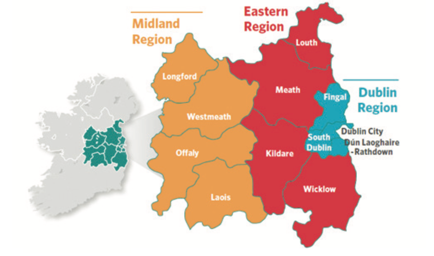
Fig 2.1: Strategic Planning Areas Eastern and Midland Region
2.4.2 Overview of the RSES for the Eastern and Midland Region
The RSES sets out the strategic framework for the economic and spatial development of the Eastern and Midland Region up to 2031.
The primary objective of the RSES is to support more sustainable settlement patterns that focus on compact growth, makes the most efficient use of land and infrastructure, and takes an integrated approach to development that provides employment opportunities and improvements to services alongside population and residential growth.
The Growth Strategy builds on the policy direction taken in the Regional Planning Guidelines of directing growth to a number of designated settlements across the region.
There are 3 policy zones identified in the strategy as follows:
- Dublin City and Metropolitan Area
- Core Region
- Gateway Region
2.4.2.1.Dublin City and Metropolitan Area
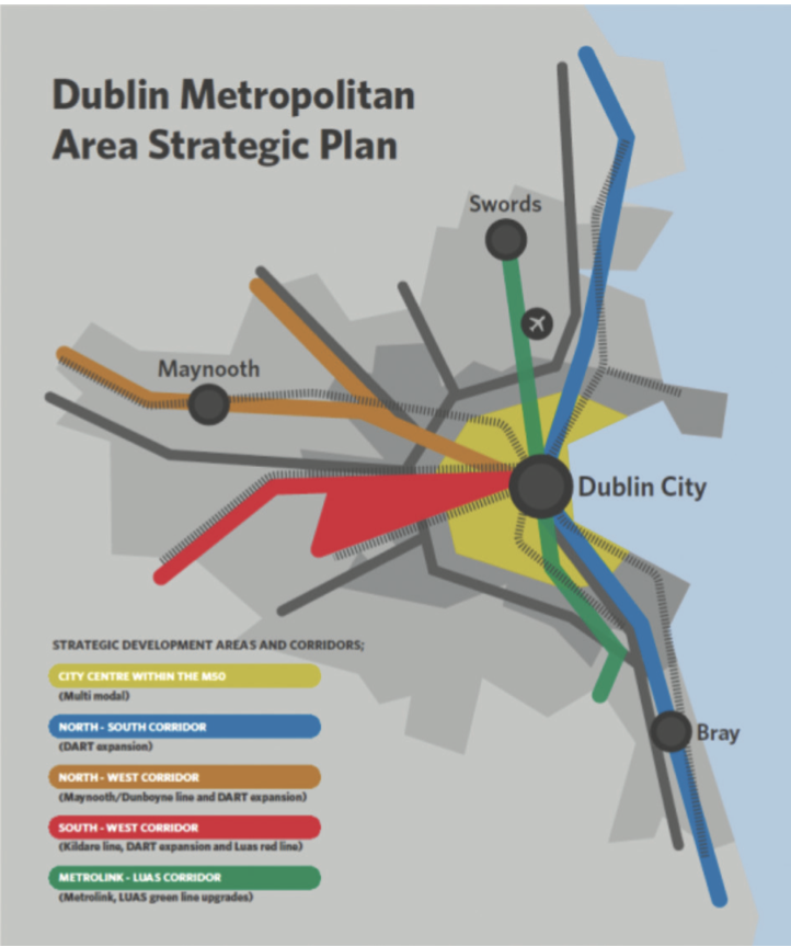
Map 2.1: Dublin Metropolitan Area Strategic Plan Area
Dublin City and Suburbs consists of the continuous built-up area of Dublin and transcends across all 4 Local Authority Areas in County Dublin. It includes settlements such as Blanchardstown, Ballymun, and Howth in Fingal, Clondalkin and Tallaght in South Dublin and Dundrum and Dun Laoghaire in Dun Laoghaire Rathdown County Council.
The NPF First Revision 2025 projects that there will be an additional 295,000 people living in Dublin City and Suburbs by 2040. This will be achieved by concentrating growth within the existing built-up footprint of the City and Suburbs area.11
The Metropolitan Area extends beyond the City and Suburbs to include major settlements that have strong connections and synergy with the city such as Swords, Dunboyne, Maynooth, Leixlip, Bray, and Greystones. 1.4 million people lived in the Metropolitan Area in 2016, which was 60% of the population in the Eastern and Midland Region.
As part of the strategy of concentrating development towards the city area, the NPF included provision for the preparation of a Metropolitan Area Strategic Plan (MASP) that sets out a high level and long-term strategic vision for the Metropolitan Area. This MASP was prepared as part of the RSES.
The Dublin MASP identifies strategic growth corridors based on their capacity to deliver compact, sustainable, and sequential growth and their proximity to existing and proposed public transport. There is a strong emphasis on aligning land use and transportation planning in order to co-ordinate policy making and investment and create more compact, sustainable communities. In addition, the requisite infrastructure requirements needed to release these lands for development have been identified.
2.4.2.2 Core Area
The Core Area consists of the peri-urban areas in the commuter catchment around Dublin, which extends into Louth, Meath, Westmeath, Kildare, and Wicklow. Key settlements include Drogheda, Balbriggan, Navan, Naas, Newbridge, and Wicklow Town.
Future growth in the Core Area is to be focused on consolidated, compact growth in key employment and service centres, with smaller settlements to grow at a more sustainable rate. There will also be a focus on improvements to services and amenities in settlements that have experienced significant population growth in order to improve the quality of the living and working environment.
2.4.2.3 Gateway Region
The Gateway Region comprises the remainder of the Eastern and Midland Region beyond the Metropolitan and Core Areas. Settlements in this part of the Region are more dispersed and rural. There is a focus on Athlone and Dundalk functioning as regional drivers for the economic growth of this part of the region. Other key settlements include Longford, Mullingar, Portlaoise, Carlow/Graiguecullen and Tullamore.
2.4.2.4 Economic Strategy
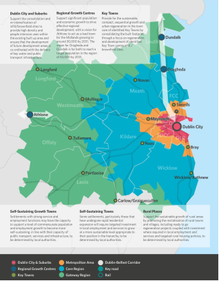
Map 2.2: Policy Areas in the Eastern and Midland Region
The Economic Strategy is positive in outlook and is focused on continuing to build on the progress made in the economy in recent years. Whilst Dublin is the primary driver of the national economy, the strategy also acknowledges the capacity of key settlements throughout the region to support and deliver economic growth. The importance of the Dublin-Belfast Economic Corridor in harnessing and driving economic growth is also recognised.
As part of the cross-cutting theme in the RSES of ‘place making’ and creating quality urban environments, there is an emphasis on improving the alignment between population and employment growth in order to create more sustainable settlements where people can enjoy a better quality of life. This will be delivered by integrating land use and transport planning and supporting high density, compact growth, particularly along high-quality public transport corridors where more sustainable travel patterns can be encouraged. The strategy also acknowledges the importance of improving connectivity and planning for and anticipating future infrastructure demands in order to maintain the competitiveness and attractiveness of the region as a place to invest, thereby stimulating economic growth and the continued delivery of targeted employment.
2.4.3 The influence of the RSES on shaping future growth in Meath
It is a mandatory requirement that there is consistency in the spatial planning hierarchy between national, regional, and local plans. This Development Plan will therefore, be consistent, in so far as is practicable, with the national and regional policy objectives set out in the NPF and RSES.
The key elements of the growth strategy of the RSES that will influence future growth and development in Meath are as follows:
- Metropolitan Growth – the MASP has identified strategic development areas in Dunboyne and Maynooth (along the north-western corridor of the Metropolitan Area) that have the capacity to deliver significant residential and employment growth. The build out of these lands will increase the critical mass of population in the Metropolitan Area, creating more compact and sustainable patterns of growth. Kilcock has been identified as a Self-Sustaining town by Kildare County Council. Given that Kildare is the lead Local Authority in relation to the town, it is necessary that the Meath CDP aligns with that of the Kildare CDP.
- Outside of the Metropolitan Area, future growth will be directed towards key designated settlements including the Regional Growth centre of Drogheda and the Key Town of Navan. The RSES recognises the level and range of services and amenities available in these settlements and their potential to continue their development as important residential, employment, and service centres in the County and wider region.
- Below the designated settlements there are a number of small-medium sized towns that play an important role in providing employment and services to the settlement and their wider catchment. There will be a greater focus on sustainable growth in these settlements including infill and brownfield development in addition to support for an improvement in the provision of amenities and services. The growth in employment provision is a key objective for these settlements in order to create “live work” communities.
- There will be a focus on investment in rural towns, villages and rural nodes to combat the decline of rural areas. The regeneration of vacant and under-utilised sites alongside the roll out of a ‘New Homes in Small Towns and Villages’ initiative between local authorities, infrastructure agencies, and local communities will provide opportunities to boost economic development and rejuvenate rural communities.12 In the open countryside a distinction is made between areas under urban influence i.e. within the commuter catchment of cities and large towns and centres of employment, and areas outside of these catchments.13 This is reflected in an updated Rural Development Pressure Map and updated rural housing policy.
The settlement hierarchy as set out in the RSES is as follows:
| Settlement Typology | Description | Location |
|---|---|---|
| RSES Settlement Typology | ||
| Dublin City and Metropolitan Area | International business core with a highly concentrated and diversified employment base and higher order retail, arts, culture and leisure offer. Acts as national transport hub with strong inter and intra-regional connections and an extensive commuter catchment. | Dublin City and suburbs Dunboyne/Dunboyne North/Clonee Maynooth Kilcock |
| Settlement Hierarchy for Meath | ||
| Regional Growth Centres | These are large towns with a high level of self-sustaining employment and services that act as regional economic drivers and play a significant role for a wide catchment area. | Drogheda |
| Key Towns | Large economically active service and/or county towns that provide employment for their surrounding areas and with high-quality transport links and the capacity to act as growth drivers to complement the Regional Growth Centres. | Navan, Maynooth |
| Self-Sustaining Growth Towns | Towns with a moderate level of jobs and services – includes sub-county market and commuter towns with good transport links and capacity for continued commensurate growth to become more self-sustaining. | Ashbourne, Dunshaughlin, Kells, Trim, Dunboyne/Dunboyne North |
| Self-Sustaining Towns | Towns with high levels of population growth and a weak employment base which are reliant with other areas for employment and/or services and which require targeted ‘catch-up’ investment to become more self-sustaining. | Laytown, Bettystown-Mornington-Donacarney, Ratoath, Enfield, Stamullen, Kilcock, Duleek. |
| Towns and Villages | Towns and villages with local service and employment functions | Towns – Athboy, Oldcastle, Ballivor, Longwood. |
| Rural | Rural villages less than 1,500 and the wider rural region | Baile Ghib, Carlanstown, Carnaross, Clonard, Clonee, Crossakiel, Donore, Drumconrath, Gormanstown, Julianstown, Kentstown, Kilbride, Kildalkey, Kilmainhamwood, Kilmessan, Moynalty, Nobber, Rathcairn, Rathmolyon, Slane, Summerhill |
Table 2.4A: Settlement hierarchy for Meath
2.5 Core Strategy Map
The Core Strategy Map (Map 2.3) set out overleaf provides a conceptual overview of the spatial planning strategy for the County. This map illustrates the designated growth centres and strategic transport corridors in the county, set within the context of the wider region.
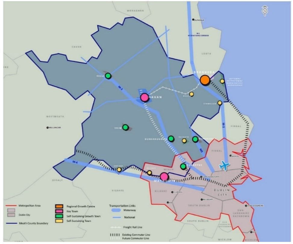
Map 2.3: Core Strategy Map
2.6 Short-Medium Term Outlook of the Plan
The preparation of this Plan comes at a time when growth has returned to the Irish economy. This has followed a prolonged period of stagnation and uncertainty during which the economy experienced volatility and change.
Associated with this economic growth is an increased demand for housing. Whilst the output of housing has increased, it remains substantially below that required in a normally functioning market. This has resulted in demand for housing continuing to outstrip supply, particularly in the Greater Dublin Area, and has led to rising house prices and rents and unprecedented levels of homelessness across the region and the State.
In recent years, inward migration has been a continuous trend in County Meath,14 placing further pressures on the demand for housing. It is, therefore, essential that there is an adequate supply of suitable housing of various types available to facilitate the growth in the economy and to ensure that the output of housing is maintained at a sustainable level that meets the needs of a growing population whilst also addressing the ‘pent up’ demand for housing following a prolonged period of inactivity.
Whilst this Development Plan is based on the assumption that there will be a continuation of positive economic growth consideration must also be given to the potential impact of Brexit on the Irish economy. It is widely accepted that whatever form of Brexit that is eventually agreed there will be considerable economic implications for the entire country. This impact will be particularly prevalent in the border counties. There are many Meath based companies that will also be exposed to these risks including agri-food, fisheries, haulage companies, the pharma-chemical industry, and retail businesses. The tourism sector is also exposed to additional risks.
Taking this into account it is proposed to include a reserve of residential lands that will not be available for development until after the Plan Period to allow flexibility that would facilitate businesses to respond to future challenges surrounding Brexit, as well as the Covid-19 pandemic and the uncertainties it would have on the local, national and international economy.
2.7 Objectives of the Core Strategy
As part of the approach of achieving consistency with the NPF and the RSES the objectives of the Core Strategy are as follows:
- To demonstrate how the Meath County Development Plan is consistent with national and regional planning strategies, guidelines and policies including national and regional population projections.
- To provide the policy framework for the settlement strategy and Local Area Plans, particularly in relation to land use zoning and population distribution.
- To ensure the co-ordination of infrastructural investment with settlements identified for future growth.
- To facilitate the population growth of Meath up to a projected population of 228,300 in the plan period and ensure the distribution of this population is targeted towards the growth centres identified in the RSES.
2.8 Layout/Content of the Core Strategy
The Core Strategy is required to address the following 3 areas:
- Population Targets
- Future Household targets and land requirements
- Settlement hierarchy/Population and household distribution
The legislative requirements in respect of the content of Core Strategies15 are clearly set out and require an evidence-based approach with regard to population and household allocation and distribution and land use requirements.
2.8.1 Guiding principles for Core Strategies
2.8.1.1 Eastern Regional & Economic Spatial Strategy
In its ‘Guiding Principles for Core Strategies’ the RSES requires Local Authorities to have regard to the settlement hierarchy in the preparation of the Core Strategy.16 There is also a recognition that the implementation of the Growth Strategy of the NPF at a regional and county level will result in inconsistencies with existing plans, particularly with regard to the quantum of land zoned for residential use.
The RSES provides the following options17 to address the issue of excess residential lands:
- Apply prioritisation measures which takes account of the sequential development of lands which are suitable for housing but may not be forthcoming in the plan period
- De-zone the land
There is also an acknowledgement that there are instances where there are settlements with long-term development potential that are not being brought forward for development.
Rather than being dependent on the release of these lands for residential development, the RSES indicates that Local Authorities should consider other suitable lands with better prospects for delivery in the short term whilst also pursuing the more strategic lands through an Active Land Management Strategy.
2.8.1.2 Development Plan Guidelines for Local Authorities (2022)
The publication of the Development Plan Guidelines for Local Authorities (2022) provides further clarity in respect to excess zoned residential lands stating that it is a policy and objective of these Guidelines that ‘zoned housing land in an existing development plan, that is serviced and can be developed for housing within the life of the new development plan under preparation, should not be subject to de-zoning’ but should instead take a phased approach. Alternative zoning uses and deletion of the zoning objective can also be considered when addressing excess.
The Guidelines advise that de-zoning should occur where the land zoned has remained undeveloped and unserviced through one or more development plan cycles, with no prospect of being serviced within the six-year life of the development plan.
The guidelines also acknowledge that in providing housing sites for development within settlements, it may be necessary to zone more serviced land and sites for residential (or a mixture of residential and other uses), than would equate to meeting precisely the projected housing demand for that settlement. The approach outlined in Section 4.4.2 of the Guidelines accepts that a degree of choice in development sites is desirable to avoid restricting the supply of new housing development through inactivity on a particular landholding or site.
The release of such lands can compensate for lands with live planning permissions that have no subsequent activity within the duration of their permission and will ensure site options are not curtailed at the advanced stages of the County Development Plan period and will ensure that a steady supply of land for housing in the right locations is built into the system.
In identifying the residential land requirement for this Plan and addressing the issue of excess lands, a significant quantum of residential lands was de-zoned to align the amount of lands zoned with the housing allocation for each settlement during the County Development Plan review. Having regard to the limited availability of remaining undeveloped residential zoned lands in some settlements, which was established following a detailed analysis at the Two-Year Review of the Plan, a comprehensive evaluation of all undeveloped residential lands in each settlement by way of a Settlement Capacity Audit (SCA) will inform future zoning and phasing of residential lands. The SCA will inform a future variation to the County Development Plan. The prioritisation/phasing of residential lands will only be utilised in the larger settlements where population growth is to be concentrated i.e. Regional Growth Centre, Key Town, or Self-Sustaining Growth Towns and only where there are fundamental reasons which support the requirement to phase such lands.
| Settlement | Reason for including a reserve of residential land |
|---|---|
| Dunboyne | To ensure there is a long-term strategy for the future development of this Metropolitan Town. |
| Navan | As the Key Town and the largest settlement in the County, it is important to have clarity and direction for the medium and long-term growth of the town. In addition, the delivery of a rail line to Navan is a cross-cutting theme of this Plan. It is therefore integral to have a development strategy that demonstrates the town has the capacity to support the population increase associated with a rail based settlement. |
| Dunshaughlin | To demonstrate the town has the capacity to accommodate a critical mass of population associated with a rail link delivered as part of Phase II of the Navan Rail Project. |
| Kilcock Environs | To provide clarity in regard to the long-term growth of this Metropolitan settlement. |
| Enfield | To provide clarity in regard to the long-term growth of this multi-modal settlement. |
Table 2.5: List of settlements where a ‘reserve’ of residential lands is to be retained
In accordance with the requirements of the NPF First Revision (2025) and associated Ministerial Guidelines, Meath County Council has identified alternative lands for rezoning to account for existing zoned lands that may not come forward during the lifetime of the current Development Plan. In identifying the location of such lands, consideration has been given to:
- The Settlement Hierarchy to ensure compliance with national and regional policy, by prioritising growth in Metropolitan areas, transport-oriented growth, provision within Regional Growth Centres and Keys Towns: Dunboyne, Kilcock, South Drogheda, and Navan.
- Post 2027 lands and White Lands that have been subject to Strategic Environmental Assessment and Appropriate Assessment in the existing County Development Plan and have been recognised for their strategic location; Dunboyne, Navan, Dunshaughlin, Enfield, Kilcock, and East Meath.
- All self-sustaining and self-sustaining growth towns with a high housing demand but limited number of units in the planning pipeline; This assessed remaining capacity in Ashbourne, Dunshaughlin, Kells, Trim, Ratoath, East Meath, Enfield, Stamullen, Duleek.
- Identification of Alternative Viable Lands in settlements with incorrect Land-Use Zonings: (Athboy).
- Lands that were zoned Post 2019 Residential Use in the Meath 2013-2019 CDP and subsequently de-zoned, have now been assessed and found to contain the necessary infrastructure to deliver housing (Athboy, Carlanstown, Donore, Duleek, Kilbride, Rathmoylan, Ballivor and Stamullen).
- Settlements with a strong track record of delivery of 100+ units annually (Navan, Dunshaughlin, South Drogheda).
As such, a number of suitable sites across 11 settlements are proposed to be rezoned to ensure an efficient quantum of land is zoned for the remainder of the Plan period and that the Core Strategy remains in accordance with the Development Plan Guidelines.
2.8.1.3 Joint Urban Area Plan for Drogheda
In recognition of the requirement for a co- ordinated strategy to maximise the growth potential of Drogheda, which is designated as a Regional Growth Centre in the NPF, Regional Policy Objective (RPO) 4.11 in the RSES sets out the requirement for the preparation of a Joint Urban Area Plan for the town between Meath and Louth County Council.
It is acknowledged that any amendments to the land use zoning strategy for the Southern Environs of Drogheda would be premature pending the preparation of this Joint Plan. However, the Council also recognises that Drogheda is one of the principle areas for population and economic growth in the Eastern and Midland Region outside Dublin.
Taking this into account it is important that land use availability is reflective of its position in the settlement hierarchy and its anticipated role in the future growth and development of the Region, which is to act as a regional driver of economic growth. The ‘Residential Phase II’ designation on the A2 ‘New Residential’ lands in the Southern Environs of Drogheda has, therefore, been removed with these A2 ‘New Residential’ land retained and being made available for development.
This will ensure there is sufficient land available to facilitate population growth and economic development based on its designation as a Regional Growth Centre. As part of the Joint Urban Area Plan process a more detailed examination of the quantum of residential and employment zoned lands, in addition to open space and community infrastructure, will be carried out. Pending the completion of this process the Council will closely monitor development activity in the area.
2.8.2 Population Projections (in effect at the time the Plan was made)
The RSES includes population projections for each Strategic Planning and Local Authority area in the region for 2026 and 2031. These projections were set out in the Implementation Roadmap for the NPF and were based on a demographic and econometric model developed by the Economic and Social Research Institute (ESRI) as part of the preparation of the NPF. A headroom factor of 25% of projected population was also incorporated into the 2026 projections to facilitate the transition towards the implementation of the growth strategy set out in the NPF.
| Census 2011 | Census 2016 | Projected population 2026 | Projected population 2031 | |
|---|---|---|---|---|
| Eastern Strategic Planning Area | 653,984 | 689,000 | 759,000-777,000 | 789,000-813,500 |
| Eastern and Midland Region | 2,209,463 | 2,328,517 | 2,566,500-2,619,000 | 2,668,000-2,740,500 |
| Meath | 184,135 | 195,044 | 216,000-221,000 | 225,500-231,500 |
Table 2.6: Regional and County population projections for 2026 and 2031
The Implementation Roadmap also recognises that there are parts of the country where projected population growth is at or above the national average. Meath is included in this list of counties. Provision is made for the allocation of an additional 25% headroom up to 2026 in these counties.
There is no allowance for this additional 25% headroom to be applied to the 2031 projection.
The population figures from Census 2016 indicate that population growth in Meath was broadly in line with that projected in the RPGs with the county experiencing a 5.9% increase in population over the five-year period 2011-2016. The population of Meath is growing at a slightly faster rate than both the region as a whole and the Eastern Strategic Planning Area where the increase was 5.4% and 5.3% during the same period.
Further analysis of the population figures for Census 2016 reveals that Meath and Fingal were the only Local Authority Areas that met the 2016 population targets set out in the RPGs.
Taking account of the recent pattern of population growth in Meath it would be prudent to utilise this additional headroom available in order to provide flexibility in a scenario where population growth would be higher than that projected. This is particularly relevant when consideration is given to the level of immigration presently being experienced in comparison to that projected in the research and projections that informed the National Planning Framework. This Research Paper projected an average net-immigration of 8,000 persons per year between 2017-2021 and 12,500 persons per year from 2021 to 2040. In comparison figures published by the CSO estimate a net immigration of 34,000 persons in 2018 and 33,700 persons in 2019. These figures indicate that the country’s population is increasing at a faster rate than anticipated in the NPF.18
Inclusive of this additional headroom, the population projection up to 2026 is as follows:
| Census 2011 | Census 2016 | Projected population 2026 | Projected population 203119 | |
|---|---|---|---|---|
| Meath | 184,135 | 195,044 | 221,250-227,500 | 225,500- 231,500 |
Table 2.7: Population projection for Meath to 2031 including headroom
The population projection for Meath is therefore 227,500 in 2026. The difference between the projected 2026 population for the county and the projected 2031 population is 4,000. When this growth is divided across the five-year period, it results in an annual increase of 800 people per year. This results in the population projection for Meath being 228,300 in 2027 (with population figures to be reviewed on the publication of the 2022 census). The consequent additional population for 2027 has been directed into Navan as this reflects the County Town and Key Town status of this settlement.
Taking account of the fact that the RSES is a 12 year strategy, the NPF Implementation Roadmap also included population projections for 2031. The RSES refers to the period 2026-2031 as the medium term and provides a population projection of between 225,500 and 231,500 for Meath by 2031. This figure does not, however take account of the additional 25% headroom allocated up to 2026.
2.8.2.1 Revised Population Projections (2025)
The National Planning Framework –First Revision (2025) provides revised national, regional and city level population projections to 2040 based on demographic and econometric modelling undertaken by the Economic and Social Research Institute (ESRI). The updated projection is that the population of Ireland will increase to approximately 5.7 million people by 2030 and to 6.1 million people by 2040. The baseline population projections for Meath are approximately 249,000 by 2032 and 267,900 by 2040.
2.8.3 Analysis of existing and projected growth rates
There was a rapid growth in population in Meath between 2006-11 when the population increased by 13%. During the following 5-year period (2011-16) a more moderate increase of 5.9% was recorded. This growth was reflective of the prevailing economic circumstances at the time whereby the national economy was performing strongly up to 2008, following which there was a curtailment of growth due to the global recession. Over the 10-year period between 2006-16 the total population increase was 20%. This equated to an annual average population increase of 3,221 persons.
| Population increase 2006-16 | Average annual increase 2006-16 | Projected increase 2016-27 | Projected annual average increase 2016-27 | |
|---|---|---|---|---|
| Meath | 32,206 | 3,221 | 33,256 | 3,023 |
Table 2.8: Population growth in Meath 2006-2027

Fig 2.2: Meath Population 2006-2026
Between 2016-2027 it is projected that the population of Meath will increase by 17.3%. This equates to an annual average population increase of 3,023 persons, which is equivalent to the annual average increase between 2006-16.
The graph above sets out the projected growth in the County up to 2027 and confirms that the pattern of growth will be along a similar trajectory as that experienced between 2006-16.
According to latest Census data, County Meath had a population of 220,826 persons in 2022 which represents an increase of 25,782 persons from 2016’s population of 195,044 persons. This significant growth rate of 13.2% is substantially more than the 5.9% growth experienced between the intercensal years of 2011 and 2016.
2.9 Housing
2.9.1 Introduction
The collapse of the property market in 2008 and the associated economic fallout resulted in the stagnation of household construction in the County and across the State. Housing figures published as part of census 2016 indicate that in the period 2011-16 just 952 residential units were constructed in Meath. This represented a 1.4% increase in the housing stock, with the total housing stock in the 2016 Census recorded at 70,649 units, rising from 69,697 in 2011. This slow-down in house building followed a sustained period of unprecedented growth in the housing stock in the County. The charts below highlight the contrasting trends in the housing market in Meath between 1991 to 2018. From 2014 when the economy began to recover house building slowly began to increase, albeit from a very low base.
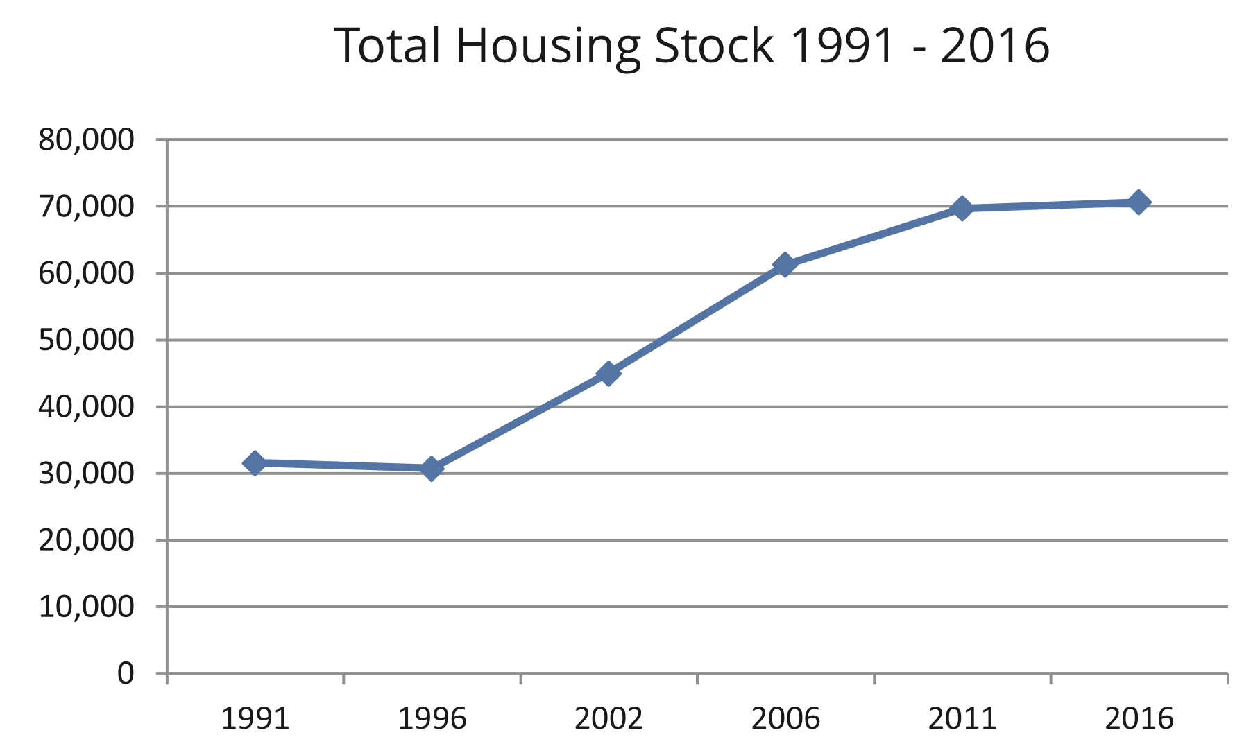
Fig 2.3: Total Housing Stock in Meath 1991-2016
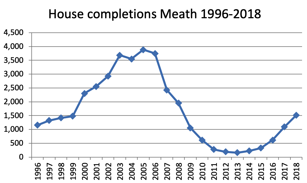
Fig 2.4: New dwelling completions Meath 1996-2018
The lack of any significant development between 2011 and 2021 when the Plan was made, resulted in residential construction lagging behind population growth. This has placed pressure on the existing housing stock, with increased rents, house prices, and homelessness evident within the County and across the region. As the economy continues to recover the demand for additional housing in the County and wider region will continue.
The Government has responded to this challenge by publishing a number of initiatives including the following:
- Rebuilding Ireland: An Action Plan for Housing and Homelessness, published in July 2016, committed to increasing housing supply to a baseline level of 25,000 units per annum by 2020.
- Housing has been identified as one of the priority areas for investment in the National Development Plan, with a capital investment of €4.2 billion available for social housing in the period 2018-2021. This funding will support the delivery of 40,000 new social housing units.20
- A €200 million Local Infrastructure Housing Activation Fund (LIHAF) was announced by the Department of Housing, Planning, Community, and Local Government in 2017. This funding will provide critical infrastructure that would facilitate an accelerated delivery of housing in key development sites where there is a high demand for housing.
- In locations with above average rental increases over a consistent period Rent Pressure Zones have been designated. Annual rent increases within Rent Pressure Zones are limited to 4%. At the time of writing the entire County was designated a rent pressure zone.
- The Land Development Agency was established in 2018. This Agency will have an initial capital budget of €1.25 billion and has an objective to deliver 150,000 homes over the next 20 years. The functions of the Agency are as follows:
- Co-ordinating appropriate State lands for regeneration and development and opening up key sites which are not being used effectively for the delivery of housing.
- Driving strategic land assembly, working with both public and private sector land owners to smooth out peaks and troughs of land supply, stabilising land values and delivering increased affordability.
40% of all housing delivered by the agency must be social/affordable with 10% to be social housing and 30% to be affordable.
The immediate focus of the agency is on managing the regeneration and delivery of housing on under-utilised State-owned lands. In the longer term the Agency will assemble strategic land banks from a mix of public and private lands and make them available for residential use in a controlled manner. This represents an exciting opportunity for dynamic partnerships with Local Authorities to address housing and regeneration issues. There are a number of land parcels in State-Ownership in Meath with potential to deliver housing. The Department of Education lands in Ashbourne, (where part of this landholding was acquired by Meath County Council for the development of social housing) is an example of such lands.
This section of the Core Strategy will focus on the projected housing demand in Meath up to 2026 and will be divided into the following sub-sections:
- The housing targets for 2016 and 2022 set out in the Regional Planning Guidelines.
- Current activity in residential construction.
- Projected housing demand for the County up to 2026.
2.9.2 Revised NPF Housing Growth Requirements (2025)
As set out in the Revised NPF, updated housing targets are needed to support a consistent and plan-led approach to successfully implement the objectives of the NPF at regional and local level through city and county development plans. The NPF Implementation: Housing Growth Requirements – Guidelines for Planning Authorities sets out the housing demand scenario up to the year 2040 by identifying average annual housing targets that are needed to be delivered to accommodate projected population growth for each local authority. The targets are informed by a range of scenarios presented by the ESRI and modelled on population growth, structural housing demand and assumptions relating to unmet demand. These revised annual housing requirements, including the requirement to consider up to 50% headroom, for the county are set out in Tables 2.2 and 2.3 above.
When the revised housing targets are applied to County Meath for the years 2025, 2026 and 2027 (up to the end of the current plan period) a housing target of 8,826 units is required to be delivered. This increases to 13,239 units when the 50% headroom rate is applied.
2.9.3 Monitoring of Population Growth and Housing Growth in the County
Section 10.3 of the Development Plan Guidelines for Planning Authorities 2022, and Section 4 of the NPF Implementation: Housing Growth Requirements Guidelines require monitoring of the Core Strategy for the county to effectively measure the delivery of housing against the housing targets. This monitoring must be carried out annually and include a breakdown of the following indicators:
| Indicator | |
|---|---|
| Residential | |
| 1. | New home completions (including through refurbishment/conversions) |
| 2. | New home completions per NPO 3 (see below) |
| 3. | Planning permissions granted for residential development with:
|
| 4. | Breakdown by relevant rural area type of rural housing:
|
To address this requirement, a Residential Tracking Monitoring System for County Meath was established as a key quantitative data source to analyse and report residential planning and construction activity. This internal dataset is informed by Central Statistic Office (CSO) data on population and employment figures, internal housing completions records and Building Control Management System data.
A review of internal planning permission data and 2022 census data indicates that market and infrastructural constraints has restricted the delivery of housing across the county. 2022 census data for the county shows that the total housing stock grew from 70,649 to 78,759 between 2016-2022. This indicates an average increase of 1,352 units annually since 2016. While internal monitoring reflects an increase in construction in more recent years, this data also indicates a shortfall of an average of 528 residential units annually on the previous target of 1,880 units per annum up to 2027 for County Meath.
In accordance with the NPF Implementation Housing Growth Requirements Guidelines it is now a target of the County Development Plan to deliver 2,942 units per annum for the remainder of the plan period. This target increases to 4,413 when the 50% headroom is factored into the calculations as required by Policy and Objective 2 of the Guidelines.
Consequently, careful monitoring must be carried out for both permissions granted, units delivered, infrastructural or other impediments to ensure the likelihood of housing delivery is considered in the context of the various obstacles. In accordance with the Development Plan Guidelines, the anticipated rate of housing delivery and the likelihood of expiring permissions commencing must also be factored into the various considerations that form part of the successful delivery of the Core Strategy. The proposed phasing of larger residential developments must also be considered.
Notwithstanding that the county has zoned a sufficient amount of land to accommodate the household allocation up to 2027, regard must be had to the historical trends for housing delivery and the significant complexities that exist in delivering housing including issues such as economic viability, site assembly and site ownership, funding, timescales for delivering the necessary physical infrastructure and the nature of speculative land management that may render certain lands unavailable within the lifetime of the plan. Accordingly, where lands cannot be bought forward for development within the Core Strategy period, a degree of flexibility in the distribution of the housing and population targets, in line with national and regional policy, is required to facilitate an adequate supply of housing to meet demand in the county. This may include allowing ‘additional provision’ of lands to provide some degree of competition and choice in the residential development land market.
Where such flexibility is awarded, an evidence-based assessment will be carried out that will consider active and expiring planning permissions, units delivered, the function of the settlement and the existing and planned infrastructural, employment and community services available to the settlement (the Asset-Based Approach). The focus and target must however be based on housing delivery as opposed to meeting targets.
In recognition of climate change mitigation and adaptation measures, self-sustaining settlements with existing or planned high quality transport services must also be recognised for their potential to contribute to national objectives to transition to a climate resilient and low carbon society. Recognition of high-quality transport settlements also accords with RPO 8.1 of the RSES which states “The integration of transport and land use planning in the region shall be consistent with the guiding principles expressed in the transport strategy of the RSES’.
Active Land Management measures undertaken by the Council such as the Residential Zoned Land Tax will also support the delivery of housing in the county and ensure compliance with National and Regional Planning Policy.
2.9.4 Household growth and the RSES
The RSES acknowledges the need to increase the delivery of housing across the country and projects that at least half of all new homes to be built nationally up to 2040 will be required in the Eastern and Midland Region.23
The RSES is a much broader strategy than the RPGs in that it is less specific at a County and settlement level with regard to household growth. No household allocation or projected occupancy rates have been provided at County/Local Authority level with the document focusing primarily on population growth.
The Strategy builds on the policy of delivering more compact and consolidated growth established in the RPGs by including an objective requiring that 30% of all new homes will be within the existing built-up area of settlements.24
The absence of any household projections or occupancy rates presents a challenge in preparing an evidence-based strategy. This is particularly pertinent given the ‘pent up’ demand for housing in the County following a prolonged period of undersupply. The RSES indicates that the updated Development Plan Guidelines to be published by the DHPLG will provide guidance with regard to future household provision. These Guidelines were not published at the time of writing and consequently the calculation/projection of future household requirements is based on the interpretation of existing available data in the absence of said national guidance.
In addition to the Development Plan Guidelines reference is also made to the preparation of Housing Need Demand Assessments (HNDA) in the RSES. The requirement to prepare a HNDA stems from National Policy Objective 37 in the NPF.25 A HNDA estimates the number of additional housing units required to meet existing and future demand. Its purpose is to provide an evidence-based rationale for housing policy and allow Local Authorities take a strategic approach to housing need and demand across all tenures. In the absence of the publication of any guidance documents and associated data and supporting material regarding the preparation of a HNDA it is not considered appropriate or practicable to prepare a HNDA at this time. In the interim period the Housing Strategy will continue to inform Housing Policy in the County.
2.9.5 Projecting Housing Demand up to 2027
As previously indicated, the NPF Implementation: Housing Growth Requirements Guidelines set revised annual housing targets for each local authority to be delivered in order to accommodate projected population growth. Appendix 2 of the Guidelines sets an annual housing target of 2,942 units for County Meath which increases to 4,413 units per annum when the 50% headroom rate is applied to the projections.
2.9.6 Securing Compact Growth
One of the underlying principles of the growth strategy in the NPF and RSES is securing more compact development. This is a continuation of the policy approach set out in the National Spatial Strategy and the Regional Planning Guidelines where there was a requirement for a sequential approach to be taken to the delivery of housing with priority given to the regeneration of infill/brownfield sites.
There is a target in the NPF and RSES to deliver at least 30% of all new homes in towns outside of the cities to be located ‘within and close to the existing built-up area’ of settlements.27
This Plan recognises the social and economic benefits of the redevelopment of brownfield lands, particularly in relation to urban regeneration, and will continue to support the delivery of compact growth and the regeneration of under-utilised sites in towns and villages throughout the County.
An analysis of the potential capacity of infill and brownfield lands zoned for residential, town centre, or mixed-use developments in all settlements indicates that approximately 6,272 units could be delivered on these lands. This equates to 31% of the household allocation for the County. The development of these lands will make an important contribution to the creation of more sustainable communities in the County and will support the implementation of the national and regional policy objectives of creating more compact settlements.
| Potential capacity of lands | |
|---|---|
| Brownfield/Infill28 | 6,272 |
| Greenfield | 14,309 |
Table 2.11: Brownfield and Infill development targets
2.10 Population and Household Distribution
The distribution of future population and household growth in this Plan is based on the key principles of the NPF and RSES of delivering more compact growth, improving the alignment of population and employment growth, and concentrating growth in the large urban centres that have a comprehensive range of services and public transport provision with the capacity to support growth.
Development therefore will be primarily concentrated in the Metropolitan Area (Dunboyne and Maynooth), the Regional Growth Centre of Drogheda and the Key Town of Navan, with more sustainable localised growth to take place in the remaining identified growth settlements.
The growth strategy of this Plan is also closely aligned with the Meath Economic Development Strategy 2014-2022, which supports the consolidation of development in the larger settlements in order to facilitate the economic growth of the County and broaden its employment base thereby reversing the continuing trend of outbound commuting to Dublin.
The distribution of future population and housing growth in the County has taken the following into account:
- Compliance with the RSES.
- The settlement hierarchy for the County as detailed in Table 2.3, which advocates an emphasis on:
- Dunboyne and Maynooth as centres within the Dublin Metropolitian area with capacity to deliver sustainable “live work” communities.
- Promoting sustainable growth in Drogheda as a designated Regional Growth Centre,
- Supporting employment and residential growth in Navan as the County’s designated Key Town.
- The need to address employment creation in existing urban areas which have experienced substantial levels of residential growth to address significant outbound commuting.
- Climate Change and sustainability, particularly the availability of public transport.
- In small towns and villages accommodating local growth at a scale appropriate to the settlement size and function.
- In rural nodes and the open countryside accommodating locally generated housing needs.
- The delivery of Phase II of the Dublin-Navan Rail line
- The availability of social and physical infrastructure.
As mandated by the NPF and RSES, the growth strategy for the County will focus less on ‘targets’ and ‘numbers’ and more on identifying settlements that have the capacity and greatest potential for growth on a sustainable platform. In addition, there will be greater co-ordination between land use zoning and infrastructure availability through the implementation of the ‘Tiered Approach to Land Use Zoning’ set out in the NPF.29 The development and implementation of this ‘Tiered Land Use Zoning’ will require a close working relationship with various agencies including Irish Water, Transport Infrastructure Ireland, and the National Transport Authority, in identifying any deficits in infrastructure and the availability of funding to carry out the necessary investments and upgrades.
The delivery of housing will be supported through the implementation of the Active Land Management Strategy for the County in addition to the promotion and identification of infill and brownfield sites for redevelopment and strategically located green field sites that would support the principles of consolidated growth.
2.10.1 Focus of Growth in the Metropolitan Area
The primary focus of future growth in the Metropolitan Area of Meath will be in Dunboyne30 and Maynooth. Dunboyne is located along the North-West Strategic Residential and Employment Corridor as set out in the Dublin Metropolitan Area Strategic Plan (MASP). It is a strategically located multi-modal settlement that has benefitted from substantial investment in road and rail infrastructure over the last decade.
The strategic location of the town makes it one of the most important settlements in the County for economic growth. This has been endorsed through high profile developments of significant FDI employment in the area by Facebook, Takeda and Aramark (Avoca). It is an objective of this Plan to build on these recent investments and continue to attract economic investment to the town.
The Dublin MASP has identified the potential for the Strategic Development Areas in Dunboyne to deliver significant residential and economic/employment generating development. It is a vision of this Plan that the development of these lands will create a sustainable "live-work" community in Dunboyne where there are jobs close to where people live and people can enjoy a balanced and healthy lifestyle in an attractive environment.
Maynooth is identified as a Key Town in the Metropolitan area in the RSES. The RSES recognises the northern environs of Maynooth, which are located in Meath, as an important location for economic and residential development that will support the future development of the town and the delivery of the Maynooth Outer Relief Road, which is a key piece of infrastructure in the sustainable growth of the town. A Joint Local Area Plan for Maynooth is to be prepared by Meath and Kildare County Councils. This Plan will provide a co-ordinated framework for the future development of Maynooth.
The RSES includes provision for the redistribution of up to 20% of the population growth targeted for Dublin City and Suburbs to the Metropolitan Key Towns of Bray, Maynooth, and Swords.31 These allocations will be determined by the MASP Steering Group comprising of representatives of the Metropolitian Local Authorities, independent of the projection provided for each County in the NPF Implementation Roadmap. At the time of writing this Group had not been established, however in order to factor a potential allocation for Maynooth Environs into this Plan, a preliminary population allocation of 1,000 persons has been allocated to the area. This will be subject to review and change when the MASP Steering Group has been established and is fully operational.
2.10.2 Focus of Growth in the Core Area
As part of the policy of promoting consolidation and compact growth, future growth in the Core Area will be concentrated in the higher tier settlements in the hierarchy. Drogheda has been identified as a Regional Growth Centre in the RSES, with the Southern Environs identified as having an integral role in the development of Drogheda as a Regional Growth Centre, with these lands having the capacity to deliver residential and economic development in strategic locations.
The designated Key Town of Navan is the largest settlement and primary growth centre in the County. A key corporate priority for the Council over the plan period is to secure the delivery of the rail to Navan. This Plan will continue to support the economic development of the town which will strengthen its position as a centre of regional enterprise and employment. Alongside the economic growth of the town, residential lands will be released for development which will increase the critical mass of the population required to support the delivery of a rail line to the town.
In the Self-Sustaining Growth Towns of Ashbourne, Kells, Trim, Dunboyne and Dunshaughlin there will be a focus on consolidation and the provision of employment opportunities in tandem with population growth in order to allow these centres to become more self-sufficient. The availability of infrastructural services and community infrastructure will also be an important factor in determining the quantum of new housing and population growth that these settlements could absorb.
The focus of growth in the Self-Sustaining Towns of Laytown-Bettystown-Mornington-Donacarney, Ratoath, Enfield, Kilcock, Duleek and Stamullen will be on attracting employment and investment in services alongside a limited population growth and a more balanced delivery of housing. As a core economic policy response which will allow “economic catch-up” as envisaged in the RSES, strategic employment zones have been identified in a number of these towns.
The remaining allocation will be directed to the Small Towns, Villages, Rural Nodes, and Open Countryside. Any growth in these centres will primarily be locally based with a shift away from commuter led development with greater emphasis on the creation of sustainable communities whereby the expansion of the settlements is proportionate to the availability of services. Development in rural nodes will be assessed on a case by case basis while also ensuring compliance with the Core Strategy.
2.10.3 Rural Areas
The NPF and RSES recognise the economic and social contribution that rural areas make at a local, national, and regional level in providing employment, access to high-quality amenity areas, delivering high-quality agricultural produce, and providing raw materials and aggregates used in the construction of our urban centres. The challenges facing these areas, which include urban generated pressures, an ageing population, connectivity, and access to infrastructure and new technologies are also recognised.
In recognition of these challenges national and regional policy has placed an emphasis on creating more sustainable rural communities by focusing on the regeneration of rural towns and villages particularly in locations that have experienced decline. Support is also provided for the development of a ‘New Homes in Small Towns and Villages’ initiative to provide services and serviced sites in rural settlements.32
The NPF and RSES make a distinction between rural areas under urban influence i.e. within the commuter catchment of cities and large towns and centres of employment, and rural areas outside these catchments.33 There is a requirement in the RSES for Local Authorities to identify areas of strong urban influence in the hinterlands of settlements on this basis.34
This Plan supports the strengthening of rural communities and the sustainable development of rural areas in accordance with national and regional policy. Full details of the Rural Development Strategy are set out in Chapter 9 of this Plan.
2.10.4 Distribution of Population and Households in the County
The Core Strategy should be read in conjunction with the supplementary table below to reflect revised land use zonings to accommodate updated national housing targets. The housing allocation for the county for the Plan period has been adjusted in accordance with the methodology set out in the Section 28 Guidelines (2025). Settlement-level distribution reflects the principles of compact growth, infrastructure capacity, sequential consolidation and sustainable transport accessibility.
Table 2.12, the ‘Core Strategy Table’, sets out the population projections and household allocation for each settlement up to 2027. This table provides details of the most recent population, population projections, the development activity in each settlement between 2016-2019, the number of unbuilt permitted units, and the household allocation for each settlement between 2020-2027.
The multi-faceted nature of settlement growth and the various socio-economic factors associated with the growth of towns and villages makes it extremely challenging to provide an exact figure for a population to grow to at a specific time. Rather than focusing on the population projection as a ‘target’ the figures provided in Table 2.12 should be regarded as a guide as to the level of growth anticipated in that settlement during the plan period. The emphasis will instead be on the delivery of the objectives of the NPF and RSES, and in particular the creation of balanced, sustainable growth.
It is acknowledged that due to various circumstances there are some settlements that may grow at a rate faster than anticipated and others which will develop at a slower rate. As part of the monitoring and implementation process of this Plan the Council will analyse settlement growth within the County, particularly following the publication of data from the next census. This exercise will form a significant element of the formal 2-year statutory review.
As part of the strategy of securing compact growth, an analysis of the potential number of units that could be delivered in the built-up area of each settlement was carried out. This figure is set out in column H of the table. This includes lands zoned as ‘New Residential’, ‘Existing Residential’, Mixed-Use’, or ‘Town Centre’ uses. The quantum of lands zoned ‘New Residential’ in each settlement has also been provided.
The total adopted Development Plan housing target for the years 2022-2024 plus the revised housing target including 50% headroom for the years 2025-2027 is 18,879. Approximately 7,678 homes were built between 2021-2025 (excluding Q4 of 2025) which leaves a requirement of 11,201 homes to be delivered to 2027.
Volume 2 of this Plan includes a Written Statement and zoning map for each settlement in the County. These Written Statements set out the strategy as to how the core strategy will be implemented in each of these settlements.35
Chapter 9 sets out the relevant policies and objectives in respect of residential development in rural nodes and the open countryside.
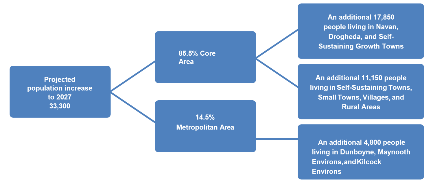
Fig 2.6: Distribution of Population in the County to 2027
It is noteworthy that the yield from mixed-use developments over the 2013-2019 plan period is relatively small at approximately 128 units. It is not anticipated that the quantum of lands zoned mixed-use as part of the Draft Plan will lead to a significantly higher yield of housing outside of that provided for in Table 2.12. An assessment of the existing residential lands in the 2013-2019 plan period resulted in a yield from the existing residential lands of c.949 units. It is considered that the delivery of residential units on lands zoned existing residential will be low as development will be restricted to backlands and gap sites in existing residential areas. The expected number of units to be delivered has been accounted for as part of Table 2.12 and is consistent with the figures above.
| Column A | Column B | Column C | Column D | Column E | Column F | Column G | Column H | Column I | Column J | Column K |
|---|---|---|---|---|---|---|---|---|---|---|
| Settlement | Population | Projected | Projected | Approximate households | Extant units | Household | Potential units | Quantum of land zoned for residential use (ha) | Quantum of land zoned for existing residential use (ha) | Quantum of land zoned for mix of uses (ha) |
| Regional Growth Centre | ||||||||||
| Drogheda* | 6,527 | 3,300 | 9,827 | 113 | 572 | 1,631 | 0 | 118.59 | 5.00 | |
| Key Town | ||||||||||
| Navan* | 30,173 | 5,900 | 36,073 | 781 | 924 | 3,204 | 1,936 | 79.8438 | 570.83 | 96.03 |
| Maynooth | 0 | 1,00039 | 1,000 | 0 | 0 | 500 | 0 | 21.36 | 0.19 | 0 |
| Self-Sustaining Growth Town | ||||||||||
| Dunboyne* | 7,272 | 3,300 | 10,572 | 48 | 119 | 2,002 | 1,180 | 72.89 | 116.97 | 26.65 |
| Ashbourne | 12,679 | 3,200 | 15,879 | 632 | 209 | 1,349 | 351 | 31.48 | 218.27 | 18.62 |
| Trim | 9,194 | 2,250 | 11,444 | 31 | 437 | 1,333 | 812 | 41.92 | 177.94 | 36.65 |
| Kells | 6,135 | 1,000 | 7,135 | 48 | 391 | 452 | 400 | 19.67 | 135.20 | 24.07 |
| Dunshaughlin* | 4,035 | 2,200 | 6,235 | 470 | 1,15640 | 1,003 | 82 | 33.09 | 110.33 | 15.26 |
| Self-Sustaining Towns | ||||||||||
| Bettystown-Laytown-Mornington East* | 11,872
| 1,500
| 13,372
| 689 | 518 | 74641 | 264 | 19.59 | 288.6 | 23.47 |
| Ratoath | 9,533 | 1,500 | 11,033 | 175 | 72 | 803 | 101 | 27.37 | 187.12 | 14.34 |
| Duleek* | 4,219 | 500 | 4,719 | 36 | 85 | 336 | 250 | 10.9 | 96.33 | 6.14 |
| Enfield* | 3,239 | 1,000 | 4,239 | 45 | 135 | 474 | 84 | 16.13 | 49.27 | 16.64 |
| Stamullen* | 3,361 | 500 | 3,861 | 1 | 215 | 290 | 58 | 11.8 | 56.07 | 8.72 |
| Kilcock* | 93 | 500 | 593 | 100 | 180 | 180 | 0 | 8.79 | 15.5 | 0 |
| Small Towns | ||||||||||
| Athboy* | 2,445 | 350 | 2,795 | 34 | 127 | 200 | 100 | 16.37 | 56.6 | 15.12 |
| Oldcastle | 1,383 | 350 | 1,733 | 16 | 0 | 166 | 110 | 9.75 | 34.51 | 13.23 |
| Ballivor | 1,809 | 100 | 1,909 | 0 | 0 | 40 | 40 | 1.93 | 39.63 | 7.09 |
| Longwood | 1,581 | 200 | 1,781 | 16 | 68 | 104 | 20 | 1.24
| 28.81 | 4.89 |
| Villages | 10,540 | 2,025 | 12,565 | 178 | 318 | 840 | 484 | 51.21 | 280.18 | 53.34 |
| Rural nodes and open countryside | 68,948 | 3,125 | 72,079 | 300 | c.300 | 1,336 | N/A | N/A | N/A | N/A |
| Total | 195,044 | 33,800 | 228,800 | 3,713 | 5,820 | 16,958 | 6,272 | 2,580.93 | 378.71 | |
Table 2.12: Core Strategy Table, Population and Household distribution to 2027
*Additional Zoning Quantum to accommodate the revised housing growth requirements as set out in the NPF Housing Growth Requirements: Implementation Guidelines (2025) is included in Table 12.2B Core Strategy Supplementary Table
A review of the Residential monitoring data that informed Table 2.12: Core Strategy Table, on Population and Household distribution to 2027 has identified an issue in the existing residential planning permissions in the County. While it was previously understood that the existing units not yet built in the county comprised 5,820 units, subsequent commencement and completion data as part of the Two-Year Review of the County Development Plan identified that 781 of these units were completed and/or expired in 2019 and therefore were outside of the household allocation period of 2020 -2027. This situation occurred as a result of delays in the preparation and adoption of the Meath County Development Plan 2021-2027 which was originally planned for adoption in 2019 but incurred significant delays pending the publication of the National Planning Framework in 2018, Regional and Economic Spatial Strategy in 2019 and the Covid pandemic in 2020.
In Variation No. 1, it is now proposed to re-allocate these units to Settlements in Tier 3 – 4 in accordance with the County Development Plan growth and settlement strategy and to ensure full utilisation of existing infrastructure and resources in the County. This data coupled with the fact that a number of settlements are reaching or have reached their targeted household allocation demonstrates the need for incorporating flexibility into the Core Strategy to ensure appropriate housing delivery against the backdrop of the current housing crisis and in line with the Government Housing Strategy, Housing for All (2021).
| Settlement | Additional Household Allocation 2020-2027 |
|---|---|
| Settlement Tiers 3-4 | 781* |
*Units recorded as extant permissions that were completed or expired prior to 2020
Table 2.12B – Core Strategy Supplementary Table outlining the lands to be brought forward as part of this variation to accommodate revised housing growth requirements as set out in the NPF Housing Growth Requirements: Implementation Guidelines (2025). For the purposes of calculating the projected number of units that may be achieved on the newly zoned A2 New Residential lands, a net development area of 80% of the site area was used to account for unknown site constraints and the need to provide non-residential space as part of future development proposals. It should be noted that the potential number of units listed in the table per settlement are indicative only and should not be viewed as a de-facto cap or unit target for the lands.
| Settlement (Column A) | Area of Adjusted Lands (ha) (B) | Previous Land Use Zoning (C) | Revised Land Use Zoning (D) | Area of Additional A2 – New Residential Zoned Lands (E) | Density (dph) (F) | Potential No. of Units (G) |
|---|---|---|---|---|---|---|
| Regional Growth Centre | ||||||
| Drogheda | 11.03 | White Lands | A2 – New Residential | 20.66 | 30-50 | 661 |
| Key Town | ||||||
| Navan | 26.37 | A2 Phasing – Post 2027 | A2 – New Residential | 26.37 | 50 | 1,164 |
| Self – Sustaining Growth Town | ||||||
| Dunboyne | 8.56 | A2 Phasing – Post 2027 | A2 – New Residential | 8.56 | 45 | 308 |
| Dunshaughlin | 5.89 | A2 Phasing – Post 2027 | A2 – New Residential | 5.89 | 35 | 165 |
| Self-Sustaining Towns | ||||||
| Bettystown– Laytown– Mornington – Donacarney | 9.7 5 3 | White Lands RA – Rural Area RA – Rural Area | A2 – New Residential A2 – Residential G1 – Community Infrastructure | 14.7 | 35 | 503 |
| Duleek * | 3.32 3.24 | RA – Rural Area A2 – New Residential | A2 – New Residential | 0.06 | 30 | 80 N/A |
| *Note: - Zoning alterations to Duleek result in net increase of 0.06ha of A2 lands | ||||||
| Enfield | 3.18 | A2 Phasing – Post 2027 | A2 – New Residential | 4.29 | 35 | 120 |
| Stamullen | 5.11 | RA – Rural Area | A2 – New Residential | 5.11 | 35 | 143 |
| Kilcock | 6.81 | A2 Phasing – Post 2027 | A2 - New Residential | 6.81 | 35 | 190 |
| Small Town | ||||||
| Athboy ** | 3.63 3.81 | RA – Rural A2 – New Residential | A2 – New Residential G1 – Community Infrastructure | -0.81 | 30 | 90 |
| **Note: Zoning alterations to Athboy results in a net loss of 0.81ha of A2 lands | ||||||
| Carlanstown | 0.8 | RA – Rural Area | A2 – New Residential | 0.8 | 30 | 20 |
| Total | 99.45 | 92.44 | 3,144 | |||
Table 2.12B: Core Strategy Supplementary Table
2.10.5 Implementation of Revised Housing Targets
As outlined earlier, a comprehensive multi-staged assessment was undertaken to determine the extent of remaining lands zoned for residential use and their ability to accommodate the revised housing targets for the County as set out in Appendix 1 of the NPF Implementation: Housing Growth Requirements Guidelines. The assessment also identified the quantum of additional lands that would be required to be zoned as part of this variation to increase the likelihood of delivering the revised targets. This included incorporating the additional provision of up to 50% above the baseline growth requirement to address potential inactivation of zoned lands.
Table 12.2B above, which should be read in conjunction with the Core Strategy Table 12.2, sets out the location and quantum of additional A2 zoned lands that are proposed to be brought forward under Variation 5. When considered collectively these lands amount to approximately 92.44ha of additional A2 – New Residential zoned lands which can deliver up to approximately 3,444 units. These additional lands, together with exiting and serviced undeveloped residential lands can achieve the revised housing targets for the county.
As shown in the Table below, the revised housing target for the County up to 2027 is 18,879 which includes the 50% headroom provision above the baseline requirement as set out in Appendix 1 of the NPF Implementation Guidelines. A total of 7,678 homes have been constructed since the Plan was adopted which results in an outstanding requirement of 11,201 homes to be delivered up to 2027 (including the 50% headroom). The existing A2 zoned lands have a capacity to accommodate approximately 6,020 no. additional homes excluding extant permissions. This increases to 11,478 when consented residential zoned lands are factored into consideration. When a delivery rate of 70% is applied to the extant permissions, a final shortfall of 1,360 units is remaining. The proposed rezoned lands have the capacity to accommodate approximately 3,444 units which will contribute to maintaining a robust supply of residential zoned lands for development and will actively address existing zoned lands that are not being brought forward for development.
| New Housing Requirement 2025 – 2027 (including 50% headroom) | Total Adopted CDP Housing Target (2022, 2023, 2024) plus Revised Target incl. headroom 2025, 2026, 2027 | Homes Built 2021-2025 | Requirement (including 50% headroom) to 2027 minus Delivery | Potential Capacity of Remaining Residential Zoned Lands to 2027 (excluding extant permissions) | Potential Capacity of Permitted Residential Zoned Lands | Total Shortfall | Potential Capacity of Land Proposed to be Rezoned as part of Variation5 |
|---|---|---|---|---|---|---|---|
| 13,239 | 18,879 (5,640+13,239) | 7,678 (includes completions Q1-Q3 2025) | 11,201 (18,879–7,678) | 221.67ha (6020 units) | 228.48ha (3,821 units**) ** assumed 70% delivery rate | 1,360 (11,201-6,020-3,821) | 3,444 |
Table 2.12C: Core Strategy Summary Table
| Settlement | Projected population increase to 2027 | % of total population growth | Approximate households completed 2016-2019 | Household allocation 2020-202742 | Quantum of land zoned for residential use (ha) |
|---|---|---|---|---|---|
| Regional Growth Centre | 3,300 | 9.76% | 113 | 1,631 | 57.09 |
| Key Towns | 6,900 | 20.41% | 781 | 3,704 | 102.92 |
| Self-Sustaining Growth Towns | 11,950 | 35.36% | 1,278 | 6,139 | 199.05 |
| Self-Sustaining Towns | 5,500 | 16.27% | 910 | 2,829 | 94.58 |
| Small Towns | 1,000 | 2.96% | 86 | 510 | 29.29 |
| Villages, Rural Nodes, and Open Countryside | 5,150 | 15.24% | 494 | 2,176 | 51.21 |
Table 2.13: Summary of population and household distribution in each settlement category
The strategic policy mechanisms by which the additional growth set out in the Guidelines will be facilitated are as follows:
- The release and rezoning of specific lands previously zoned for residential development post 2027 to A2 – New Residential.
- The rezoning of specific lands previously zoned RA – Rural Area and Whitelands to A2 – New Residential
- The allocation of additional housing targets to each of the settlements where lands are proposed to be rezoned to A2 – New Residential as part of this variation
- The identification of lands that were previously de-zoned and deemed suitable to accommodate additional growth to be brought forward as part of the County Development Plan review process.
Furthermore, and having regard to Section 86(7) of the Planning and Development Act 2024 (as amended), once commenced, the Planning Authority may consider granting planning permission for housing developments that are located on appropriately zoned lands and where the proposed development(s) would result in an exceedance of the housing targets for that settlement subject to compliance with the relevant policies and objectives pertaining to that settlement.
2.11 Economic Development
The Council set out an ambitious framework for economic development in the County in the Economic Development Strategy for Meath 2014-22.43 The overriding objective of this Strategy is to facilitate more jobs within the County thereby improving the jobs ratio and reducing the volume of outbound commuting. This Plan will continue the implementation of this Strategy and will seek to build on the successes achieved to date.
The direction and underlying principles of this Core Strategy are consistent with the national and regional economic policy set out in the NPF and RSES in that it advocates that future growth should take place on a sustainable platform that concentrates development in local and regional centres of growth that have the capacity to accommodate significant development in a consolidated urban environment.
The concept of the ‘live-work’ community model also emerged from the spatial implementation phase of the Strategy and will continue to be promoted as a model of best practice in place making and the creation of balanced and healthy communities. This concept is strongly endorsed in both the NPF and the RSES.
The 5 strategic centres of employment were identified for growth in the Economic Strategy are Navan, South Drogheda, Dunboyne North, Ashbourne, and Kells. Having regard to the need to generate employment opportunities in centres which have experienced high levels of population growth without commensurate employment development and high levels of outbound commuting it is proposed to identify further 7 strategic employment sites as follows: Kells, Ratoath, Dunshaughlin, Laytown, Maynooth, Navan and Enfield.
Full details of the Economy and Employment Strategy are set out in Chapter 4 of this Plan.
2.12 Retail Development
A Retail Strategy for the County has been prepared as part of this Plan. This Strategy is consistent with the Retail Hierarchy for Meath as set out in the Regional Retail Strategy for the GDA 2008-2016. It has also been informed by the DECLG Retail Planning Guidelines (2012).
The aim of this Strategy is to sustain and improve the retail competitiveness of the County, address expenditure leakage, and ensure an equitable and sustainable distribution of retail floorspace across the County. An evidence-based approach has been taken to the requirement of any additional lands for convenience or comparison floorspace and has been based on projected changes to the local population, consumer spending, and turnover potential.
Full details of the Retail Strategy are set out in Chapter 4: Economy and Employment and Appendix 4 Retail Strategy.
2.13 Climate Change
Whilst Climate Change policies and mitigation measures are set out at a National and International level Local Authorities have a central role in the implementation of these policies and in promoting behavioural and attitude change towards climate change.
A Climate Change Adaptation Strategy has been prepared for this Plan as part of the requirements of the National Climate Change Adaptation Framework (2012). This Strategy will ensure that this Plan will appropriately address adaptation to climate change.
Climate change is a cross cutting theme of the Plan, however, climate change is specifically addressed in detail as part of Chapter 10 Climate Change.
2.14 Core Strategy and SEA/AA
A Strategic Environmental Assessment and Appropriate Assessment has been prepared in tandem with the Core Strategy. The Core Strategy has had regard to both assessments with any changes/recommendations incorporated into the strategy. All subsequent land use plans arising from Meath County Development Plan 2021-2027 will be subject to full environmental assessment such as Strategic Environmental Assessment and Appropriate Assessment in compliance with existing legislation.
2.14.1 Policies
It is the policy of the Council:
CS POL 1
2.14.2 Objectives
It is an objective of the Council:
CS OBJ 1
To secure the implementation of the Core Strategy and Settlement Strategy, in so far as practicable, by directing growth towards designated settlements, subject to the availability of infrastructure and services.
CS OBJ 2
To ensure that sufficient zoned lands are available to satisfy the housing requirements of the County in designated settlements over the lifetime of the Plan.
CS OBJ 3
To ensure the implementation of the population, housing growth and household allocation set out in the Core Strategy and Settlement Strategy, in so far as practicable. Meath County Council will monitor the number of units that are permitted and delivered as part of the implementation of this objective, in compliance with the Development Plan Guidelines 2022 and the NPF Implementation Housing Growth Requirements Guidelines 2025.
CS OBJ 3A
The 781 residential units shall only be applied to Tier 3 to 4 Settlements where there is a demonstrated demand for housing and sufficient supporting services available including access to employment, public transport, water/wastewater, commercial/retail services and social infrastructure. This will be implemented through the Development Management function, monitored by the Forward Planning Department and applicable until such time as the National Planning Framework Review is completed and adopted.
CS OBJ 4
To achieve more compact growth by promoting the development of infill and brownfield/ regeneration sites and the redevelopment of underutilised land within and close to the existing built-up footprint of existing settlements in preference to edge of centre locations.
CS OBJ 5
To deliver at least 30% of all new homes in urban areas within the existing built-up footprint of settlements.
CS OBJ 6
To strengthen the social and economic structure of rural towns and villages by supporting the re-use of existing buildings and the regeneration of under-utilised buildings and lands.
CS OBJ 7
To operate an Order of Priority for the release and development of residential lands with any lands identified as being ‘Post 2027’ not being available for residential development during the lifetime of the subject development plan and consequently planning permission for residential dwellings will not be granted on these lands by Meath County Council.
CS OBJ 8
The existing Southern Environs of Drogheda Local Area Plan 2009 (The LAP) shall remain the statutory plan for the Southern Environs of Drogheda until such a time as it is replaced with a Joint Urban Plan for Drogheda in conjunction with Louth County Council having regard to the requirements of the Report of the Drogheda Boundary Review Committee (February 2017), the National Planning Framework, and the Eastern and Midland Region Regional Spatial and Economic Strategy. This plan shall be read together with the County Development Plan 2021-2027. The County Development Plan 2021-2027 shall take precedence if a conflict arises between the Plans and the conflicting provision of the LAP shall cease to have effect.
CS OBJ 9
To prepare new local area plans for the following settlements within the lifetime of this Plan: Navan, Dunboyne, Ashbourne, Trim, Kells, Dunshaughlin, Ratoath, Bettystown-Laytown-Mornington East-Donacarney, Duleek, Enfield, Athboy, Oldcastle, Stamullen.
CS OBJ 10
To prepare, as a priority, a Joint Vision and Urban Area Plan for Drogheda in partnership with Louth County Council within the lifetime of this Plan in accordance with the requirements of Regional Policy Objective 4.8 of the RSES for the Eastern and Midland Region and the recommendations set out in the Report of the Drogheda Boundary Review Committee published in February 2017. As part of the preparation of this Plan, a detailed infrastructure assessment, consistent with the methodology for a Tiered Approach to Zoning under Appendix 3 of the NPF will be undertaken.
CS OBJ 11
To support the implementation of the policies and objectives set out within the Maynooth and Environs Joint Local Area Plan 2025 – 2031.
CS OBJ 12
To ensure that all settlements, in as far as practicable, develop in a self-sufficient manner with population growth occurring in tandem with the provision of physical and social infrastructure.
CS OBJ 13
Support the implementation of the National Climate Change Strategy and the National Climate Change Adaption Framework Building Resilience to Climate Change 2012 through the County Development Plan and through the preparation of a Climate Change Adaptation Plan in conjunction with all relevant stakeholders.
CS OBJ 14
To support the economic growth of Meath as set out in the Regional Spatial and Economic Strategy and the Economic Development Strategy for County Meath 2014-2022.
CS OBJ 15
To continue to promote economic development of the Dublin-Belfast Economic Corridor.
CS OBJ 16
To support the creation of ‘live work’ communities, in which employment and residential accommodation are located in close proximity to each other and strategic multi-modal transport corridors, and to reduce long distance commuter trends and congestion.
CS OBJ 17
To work closely with government departments and agencies to assist in the delivery of critical infrastructure that would facilitate the economic growth of the county with particular reference to the development of the rail to Navan.
CS OBJ 18
To incorporate the relevant housing needs for 2027 into the Housing Strategy over the lifetime of the Development Plan.
CS OBJ 19
To implement an Active Land Management Strategy in relation to vacant land in settlements within County Meath and to maintain and update as required a Vacant Sites Register to ensure efficient and sustainable use of the County’s land resources in accordance with the provisions of the Urban Regeneration and Housing Act 2015 as well as the Planning and Development Act 2000, as amended.
CS OBJ 20
To undertake a review during the lifetime of the Plan so as to ensure compliance with Climate Change requirements as outlined in the forthcoming Updated Development Plan Guidelines for Planning Authorities as per section 10(2)(n) of the Act.
CS OBJ 21
To undertake, over the lifetime of the Plan, the measures outlined in Appendix 15 relating to the Implementation & Monitoring of the Plan.
- 1 - Section 10(1A) of the Planning and Development Act 2000 (as amended)
- 2 - Sections 20A, 20B, and 20C of the Planning and Development (Amendment) Act 2018
- 3 - National Policy Objective 1a and 1b of the NPF
- 4 - National Policy Objective 3c of the NPF
- 9 - A Local Economic and Community Plan is a six year strategy that sets out the objectives and actions needed to promote and support the economic and community development of a local authority area. The Meath LECP 2016-2021 is available from the following location: County Meath Local Economic and Community Plan 2016-2021
- 10 - Section 23 of the Planning and Development (Amendment) Act 2018
- 11 - National Policy Objective 3b of the NPF sets a target of at least half (50%) of new homes in the City and Suburbs to be delivered in the existing built-up area.
- 12 - National Policy Objectives 18a and 18b in the NPF
- 13 - National Policy Objective 19 of the NPF and Regional Policy Objective 4.78 of the RSES
- 14 - Census 2016 recorded 82,346 immigrants arriving in Ireland in the year to April 2016 in comparison to 53,267 in April 2011. Population and Migration Estimates published by the CSO in August 2019 estimate the number of immigrants to the State to be 88,600 between April 2018 and April 2019
- 15 - Section 10(2A) of the Planning and Development Act 2000 (as amended)
- 16 - Section 4.3 of the RSES ‘Defining a Settlement Typology’
- 17 - Section 4.3 of the RSES ‘Taking Account of Existing Plans’
- 18- See page 43 of the ‘Prospects for Irish Regions and Counties’ published by the ESRI and the CSO ‘Population and Migration Estimates’ published in August 2019
- 19 - The Implementation Roadmap for the NPF does not provide for an additional 25% headroom in 2031
- 20 - National Development Plan 2018-2027
- 23 - Section 9.3 RSES Housing and Regeneration
- 24 - Regional Policy Objective 3.2 RSES
- 27 - National Policy Objective 3c of the NPF and Regional Policy Objective 3.2 of the RSES
- 28 - This includes greenfield sites in the ‘existing built-up area of settlements’
- 29 - Appendix 3 of the NPF
- 30 - This includes lands at Dunboyne North and Clonee’
- 31 - Section 5.7 of the MASP ‘Housing Delivery’
- 32 - Regional Policy Objective 4.78 of the RSES
- 33 - The NPF defines a commuter catchment as the area from which at least 15% of the relevant settlement workforce is drawn from outside the settlement area
- 34 - Map 9.1, Rural Area Types Development Pressure Map, Volume 3 Book of Maps, Meath County Development Plan 2021-2027
- 35 - Following the adoption of this plan it is intended to prepare a Local Area Plan for each of the following settlements: Navan, Dunboyne/Clonee, Ashbourne, Trim, Kells, East Meath, Dunshaughlin, Duleek, Enfield, Stamullen, Oldcastle, Athboy and Ratoath. A Joint Local Area Plan for Maynooth is to be prepared with Kildare, a Joint Urban Plan is to be prepared for Drogheda with Louth.
- 36 - This figure does not include the units completed 2016-2019. The calculation of the household allocation has factored in the ‘pent up ‘demand for housing which has resulted in an increase in the average household occupancy rate for existing households. As the housing market continues to normalise and supply begins to meet demand it is anticipated that the average household occupancy rate for both existing and new households will begin to decrease.
- 37- This includes both greenfield and brownfield sites in the built-up area of each settlement and consists of lands zoned for town centre, mixed-use, and residential development. For clarification these units have been included in the Household allocation.
- 38 - This does not include the 38.1ha SDZ at Clonmagadden. This SDZ will span over multiple Development Plans. Taking this into account in addition to the fact that a review of the Planning Scheme is required, the SDZ has not been included in the Household allocation for Navan.
- 39 - Half of this population allocation (500 persons) is taken from the MASP allocation. This is provided for in section 5.7 of the Dublin MASP ‘Housing Delivery’. This is a preliminary figure, with the final figure to be agreed with the MASP Implementation Group. At the time of writing the MASP Implementation Group had not been established.
- 40 - Under a Strategic Housing Development application permission was granted for 913 units. This is a 10-year permission where it is envisaged the lands will be developed across multiple Development Plans . Taking this into account 600 (two-thirds) of the 913 units have been included in the Household allocation during this Development Plan.
- 41 - Includes provision for 30 no. social housing units
- 42 - Does not include the units completed 2016-2019
- 43 - Economic Development Strategy for Meath 2014-2022