1. Introduction
1.1 Beach Management Plan
The Laytown, Bettystown and Mornington Beach Management Plan (BMP) will act as the main reference document for the day to day management of the beach and will be proactively and reactively updated as and when required.
At regular meetings between MCC, and the authors of the Draft NIS and Draft Plan, Draft Plan Recommendations were iteratively amended to avoid adverse effects to European sites (i.e. ‘mitigation by design’), taking account of relevant stakeholder submissions.
The primary issues in summary are Management Structure, Beach Wardens, Access, Parking and Traffic, Beach Safety, Community, Sports and Recreation, and the existing Bye-Laws. Coastal Erosion is not part of the scope of the BMP and will be dealt by MCC in separate studies.
1.2 Location
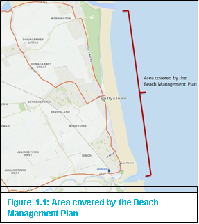
The Beach Management Plan covers the areas of coast adjacent to the Laytown, Bettystown and Mornington
in Co. Meath.
Meath has the second shortest coastline of Ireland’s coastal counties (21km), all of which is classified as soft coast. The beach is located on a 5km long beachfront which stretches from Mornington at the River Boyne, boarding County Louth to Laytown at the River Nanny.
a) Type of Beach
Laytown, Bettystown and Mornington beach consists of a fine sand beach backing onto sand dunes.
b) Bathing Waters
Laytown / Bettystown is the only designated bathing water in the Bathing Water Regulations (2008) along this stretch of beach. The Boyne River ischarges to the sea to the north of the bathing water, while the Nanny, Mosney and Delvin Rivers discharge to the sea to the south of the bathing water. The bathing area is approximately 1.5km in length and 0.6km2 in area.
c) Sea Action
The dominant wave direction along the Meath coastline is from the east to south-east, and the prevailing drift therefore from south to north. The Beach is experiencing a net loss of sediment and the beach levels are lowering significantly.
Sand from Laytown / Bettystown is being carried north where it has been trapped by the training walls at the Boyne entrance. The holding capacity of the south training wall, which was built in the 1970s, is now limited due to the growth in the width of the beach at Mornington. As a consequence, Drogheda Port Company is required to frequently dredge the entrance channel at the Boyne Estuary to remove sand which now bypasses the end of the south training wall.
d) Tides
The beach is mesotidal with a tidal range between 2-4m.
e) Right of Way
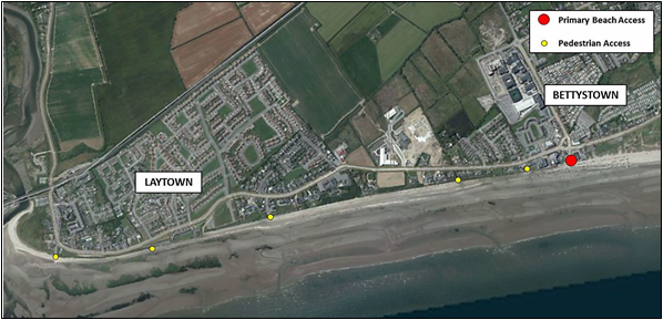
Public Rights of Way which gives access to seashore, riverbank or other place of natural beauty or recreational utility, have been identified to date by Meath County Council in accordance with Section 10(2)(o) Planning and Development Acts 2000-2011. There are twelve Public Rights of Way to the Seashore in the Bettystown area, as set out in Section A14 of the Meath County Development Plan 2013-2019.
1.3 Beach Access
Seaview Terrace is the primary vehicular access point onto the beach. The access is dominated by vehicular traffic as footpaths for pedestrian access are narrow. Generally it is accepted that the access needs to be improved and upgraded for pedestrian safety and improved streetscape.
Please refer to Recommendations 1, 2 and 3 in Appendix A for proposed upgrades to Seaview Terrace.
The Foreshore Bye-Laws control/govern the traffic access to the beach and parking on the beach.
Figure 1.2: Beach Access Points
1.4 Drogheda Port Company
The area covered by the BMP falls within the jurisdiction of Drogheda Port Company which is a commercial state port handling over 1 million tonnes of cargo annually in addition to over 700 vessel calls. The Company provides port facilities for both general freight and container services. The limits of the Port Company are defined by the Harbours (Amendment) Act 2009 but essentially run from Benhead to the south and Clougherhead to the North.
1.5 Recreational Areas
Car parking is permitted on the beach from 150m north of the Seaview Terrace beach entrance all the way south to Laytown. The densest area of car parking on the beach is directly in front of the Seaview Terrace and this also forms the main recreation area of the beach. This is also dependant on whether the tide is in or out. W hen the tide is out, people generally use the part of the beach in front of the parking area; however this may not be possible when the tide is in. People also use the section of the beach north of the parking area which is a lifeguard patrol zone during the summer months. The northern portion of the beach is most popular with walkers, with many people preferring the soft sand on the more southerly section of the beach around the Seaview Terrace entrance.
1.6 Car Parks
Motorists presently park on Bettystown Beach. Aside from the beach itself there is no public car park in Bettystown, owned or operated by MCC, which provides car parking for beach users. MCC are therefore under pressure to accommodate all car parking on the beach.
Other large car parks in the town within walking distance of Seaview Terrace include the Funtasia car park (approximately 3 minute walk), the Anchorage car park (approximately 4 minute walk) and Tesco car park (approximately 7 minute walk). These are all privately owned and have various restrictions and parking management measures in place which may deter beach users from utilising them.
An area for car parking is provided close to the Mornington Beach pedestrian access.
A temporary car park of approximately one hundred spaces is provided in Laytown every year in close proximity to the existing train station car park and next to the children’s playground. During the Laytown Races all cars are removed from the beach, it is currently the only day of the year when parking is entirely removed from the beach.
1.7 Public Toilet Facilities
Currently, the only toilet facilities are located in the Arcade building in Bettystown and are accessed from the street. There are no plans to locate toilets at Layton or Mornington at present.
Please refer to Recommendation 1 in Appendix A for proposed upgrades to the existing public toilets.
1.8 Infrastructure
The following infrastructure is in place on the beach;
- Coastal protection measures are present from the southern end of Laytown beach carpark and include relatively recently constructed gabion stone cages with stone toe protection present along this stretch of shoreline to the southern end of Netterville While these measures protect the shoreline, they also exert pressure on the beach with no dry sand present in this area and extensive stretches of the underlying stone basement exposed in the intertidal zone.
- Coastal protection measures consisting of stone armour are present from Netterville Terrace as far as the southern end of Laytown Racecourse with similar pressure to the beach as outlined
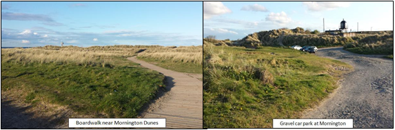
- Boardwalks provided in the Dune System at Mornington;
- Gravel car park at Mornington
Figure 1.3: Mornington Dunes boardwalk and car park