To ensure that all settlements, in as far as practicable, develop in a self-sufficient manner with population growth occurring in tandem with the provision of physical and social infrastructure.
03. Settlement and Housing Strategy
Dúnta3 Sam, 2021, 08:59 - 3 Sam, 2021, 09:00
|
Please note that this is the Original Meath County Development Plan 2021-2027 (adopted on the 22nd September, 2021). Following the adoption of Variation No. 1 & Variation No. 2 on the 13th May, 2024 and Variation No. 3 on the 27th January, 2025, this Plan has now been superseded by the Consolidated version. The Consolidated version of the Meath County Development Plan 2021-2027 (incl. Variations 1, 2 & 3) is available to view at this link HERE |
3.1 Introduction
This Chapter seeks to transpose the high-level objectives of this Plan as detailed in the Core Strategy into a more local context by setting out a strategy for the future direction of settlement growth in the County. It will identify the settlements where growth will be prioritised and will inform infrastructure investment decisions required to facilitate this growth.
The settlement structure in Meath consists of different categories of settlements ranging from small rural villages to large urban towns. These settlements have an important function at a local, county, and regional level, dependent on their position in the settlement hierarchy; in supporting jobs, providing services and a mix of housing options, and acting as a focal point for community networks and activities.
This Plan recognises the importance of creating a strong network of settlements where there are a broad range of services, amenities and job opportunities as this will contribute to a more balanced and healthy quality of life for our communities.
A settlement hierarchy for the County has been developed to take account of the role and function of each settlement and is positively aligned to the new hierarchical format set out in the RSES.
The second part of this chapter outlines the housing policy in the County over the lifetime of the Plan, which focuses on the creation of sustainable communities and takes into account the key findings of the Housing Strategy and current Government policy in relation to the delivery of housing in the country.
3.2 Settlement and Housing Strategy Vision
To facilitate the sustainable growth of the towns and villages throughout the County by promoting consolidation and compact development in an attractive setting that provides a suitable mix of housing and supporting amenities and ensuring co-ordinated investment in infrastructure that will support economic competitiveness and create a high quality living and working environment.
3.3 Context
To set the context of the Settlement Strategy, an overview of recent trends in population and employment growth in the County will be provided. This information has been extrapolated from Census data which is a useful source of up to date information that has assisted in the preparation of an evidence-based growth strategy for this Plan.
3.3.1 Population Growth and Distribution
The population of Meath in 2016 was 195,044. This represents a 5.9% increase (10,909 persons) on the 2011 population, which was 184,135. This rate of increase was slower than the previous 5-year inter-censual period when the population increased by 13% (21,304 persons) from 162,831 to 184,135. This slower rate of growth is reflective of the changing economic circumstances in the country before and after 2008.
The total population increase over the 10-year period 2006-16 was 32,213 persons, which equates to a 19.8% increase. This was the third highest growth rate recorded in the Eastern and Midland Region behind Laois (26.3%) and Fingal (23.3%).
In 2016 there were 2,328,517 people living in the Eastern and Midland Region. The population of Meath accounted for 8.4% of the regional population at this time. The Eastern Strategic Planning Area, which consists of the counties of Meath, Kildare, Louth, and Wicklow, had a population of 688,857 in 2016, 28.3% of whom resided in Meath.
At a County level, the population in the urban areas of Meath are increasing at a higher rate than rural areas, with an 8.9% increase recorded in aggregate town areas in comparison to a 1.9% increase recorded in aggregate rural areas between 2011-16.1 This has resulted in the proportion of the total population residing in urban areas increasing by 1.6%, from 57% to 58.6%. Inversely the proportion of the population living in rural areas has decreased from 43% to 41.4%.
The influence of Dublin on settlement growth remains apparent with commuter-based settlements in the south and south-east of the County (including Ashbourne, the East Meath Settlements, and Enfield) experiencing the highest levels of population growth. In 2016 Ashbourne was the fastest growing town in the County with the population increasing by 11.7% to 12,679. This was twice the rate of growth recorded in Navan, which increased its population by 5.7% to 30,173.
|
Settlement |
Population 2011 |
Population 2016 |
Actual change |
% change |
|---|---|---|---|---|
|
Ashbourne |
11,355 |
12,679 |
1,324 |
11.7% |
|
Trim |
8,268 |
9,194 |
926 |
11.2% |
|
Enfield |
2,929 |
3,239 |
310 |
10.6% |
|
Bettystown-Laytown-Mornington-Donacarney |
10,889 |
11,872 |
983 |
9% |
|
Stamullen |
3,130 |
3,361 |
231 |
7.4% |
Table 3.1: Settlements in Meath that recorded highest levels of growth 2011-16
Map 3.1 overleaf details the population change in the County by Electoral Division (ED) between 2011-16. The dark blue colour depicts the highest levels of growth (between 8.6-20.4%). Over half of the EDs experienced population growth of between 2.7-8.5%. As expected, the highest growth levels were primarily experienced in the east and south-east of the County. Trim also experienced high levels of growth whilst there was also strong localised growth to the south-west of Kells.
The ED ‘Navan Rural’ recorded the highest numerical growth with an additional 1,460 persons or 5.5% increase. This was followed by St. Mary’s which includes South Drogheda and East Meath where there were an additional 1,095 persons. The EDs of Donaghmore (764 additional persons) and Kilbrew (610 additional persons) (both of which include the town of Ashbourne), Ratoath (521 additional persons) and Trim Rural (788 additional persons) also recorded significant growth.
The ED ‘Castlejordan’ in the south-west of the County bordering Offaly experienced the biggest decline in population with a decrease of 44 persons resulting in a total population of 427 persons living in the ED in 2016.
The population of the County at Electoral Division (ED) level is set out in Map 3.2 below. The darker colours represent the EDs with the highest population. As would be expected, these are within and adjacent to the main urban centres. The EDs with a lower population are in more rural locations in the northern and western parts of the County.
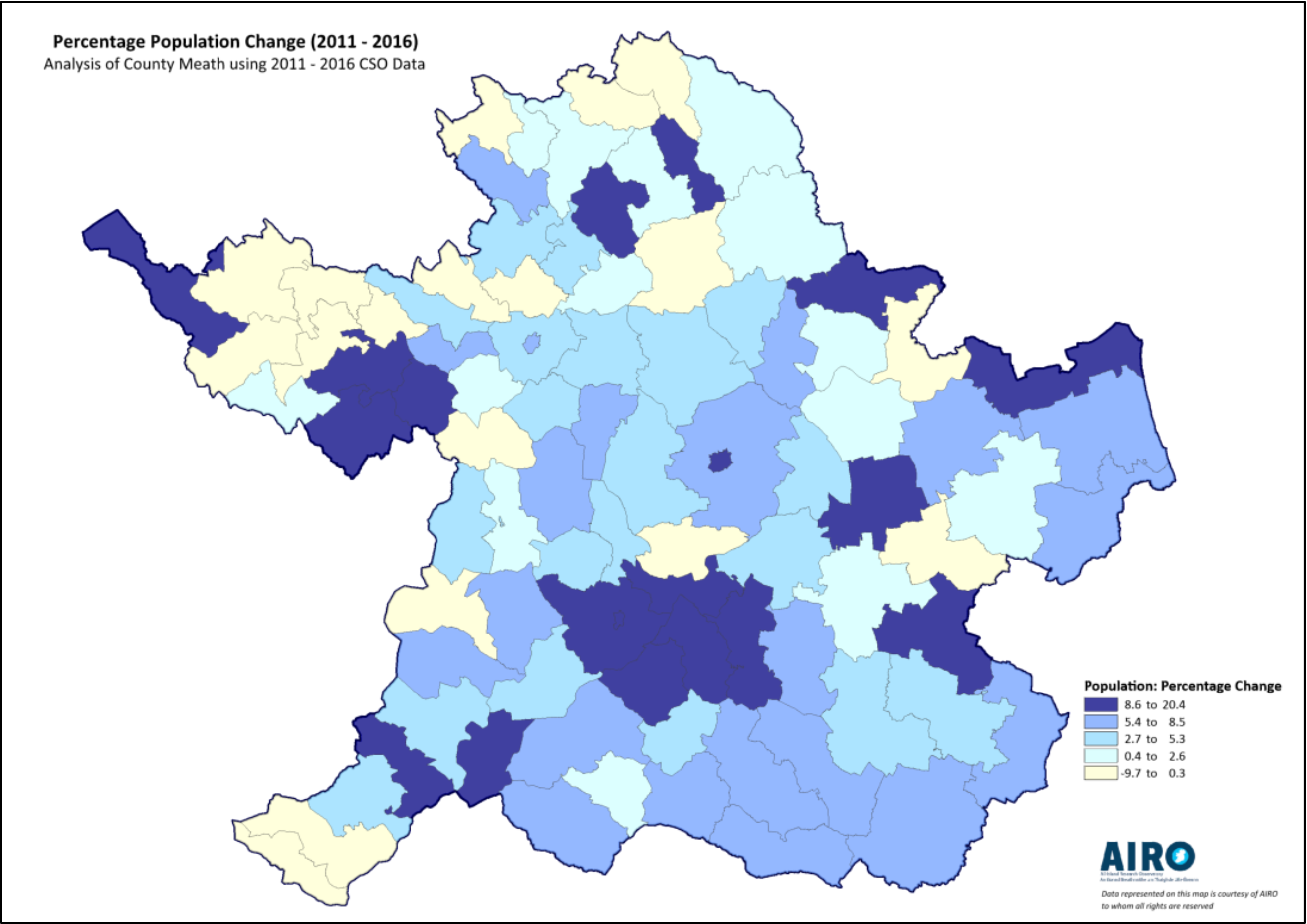
Map 3.1: Population change by Electoral Division 2011-16
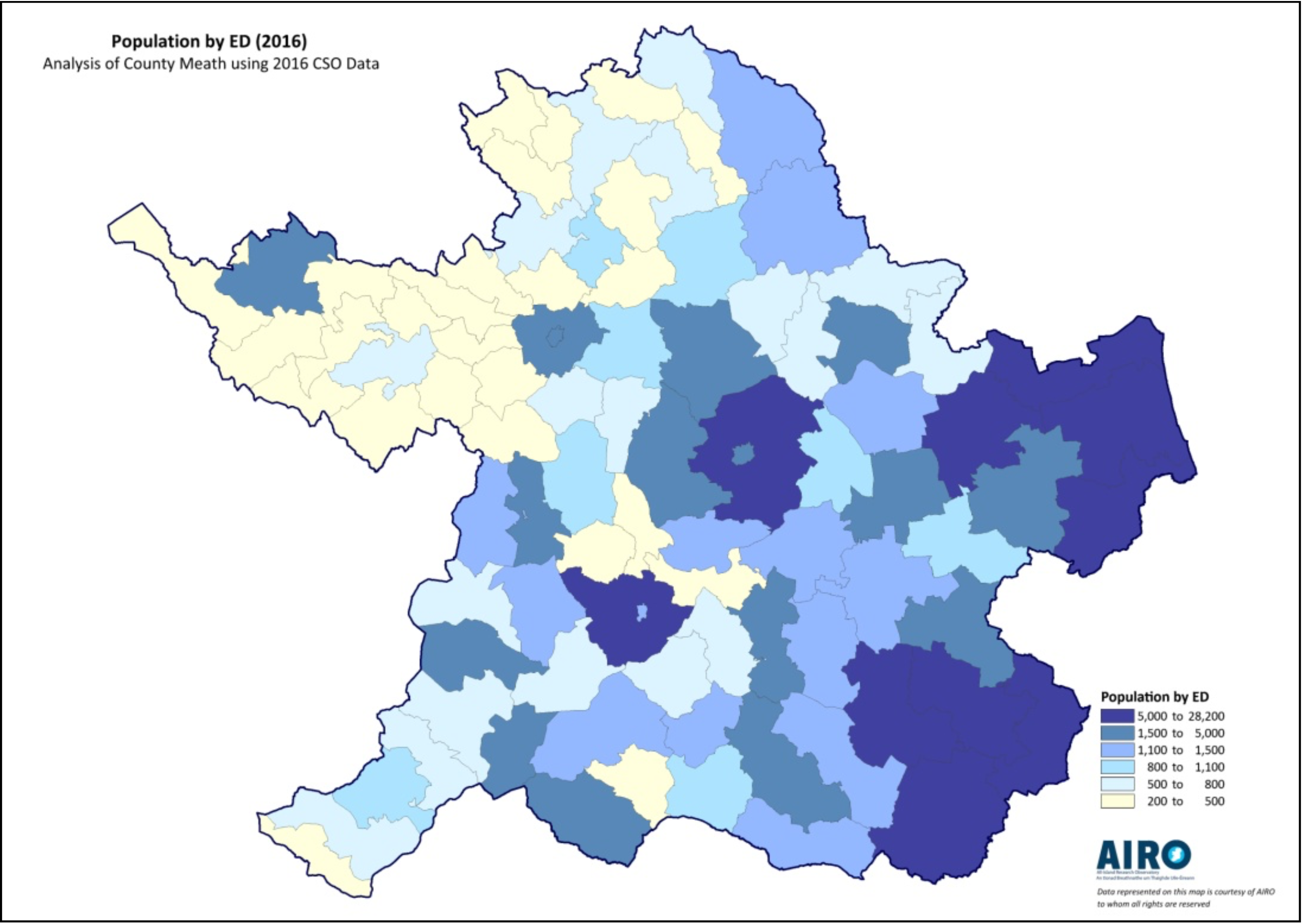
Map 3.2: Population by Electoral Division 2016
The urban centres of Navan, Trim, and Kells recorded the highest densities in 2016, with a concentration of over 2,000 persons per km² in Navan and Trim, and 1,990 persons per km² in Kells.
A breakdown of the population in each Municipal District is set out in Table 3.2 below. The more rural Municipal Districts cover a wider land area than those Municipal Districts with a more urbanised population.
|
Municipal District |
Population 2016 |
|---|---|
|
Ashbourne |
29,178 |
|
Kells |
32,398 |
|
Laytown-Bettystown |
33,752 |
|
Navan |
34,931 |
|
Ratoath |
33,590 |
|
Trim |
31,195 |
|
Total |
195,044 |
Table 3.2: Population by Municipal District 2016
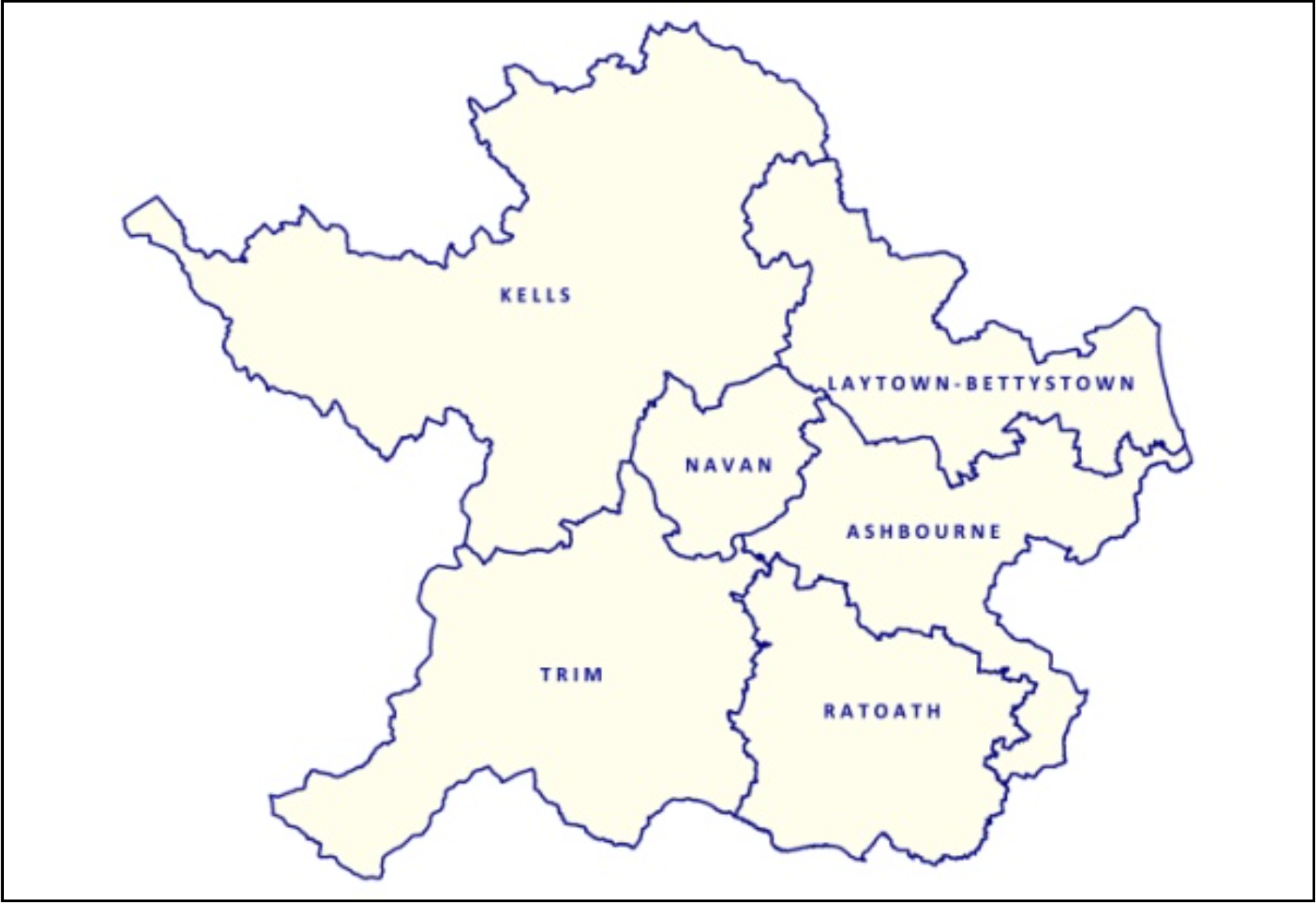
Map 3.3: Municipal Districts 2016
3.3.2 Age Profile
The age structure of a population is influenced by patterns of natural increase and migration. In order to analyse recent trends in the age profile of the County a population pyramid for the County and the State based on 2016 Census data has been prepared (Fig. 3.1 below and 3.2 overleaf). These pyramids are useful in highlighting the differences in age cohorts.
The average age in the County in 2016 was 35.2 (33.8 in 2011) in comparison to 37.4 for the State (36.1 in 2011). 83.4% of the population in the County is below the age of 65. This compares with an average of 79.6% for the State. Child dependency2 in the County is the highest in the State with 39% of the population under the age of 14 in comparison to an average of 32.3% for the State.
Old dependency3 in the County increased from 13.5% in 2011 to 16.6% in 2016. However, this remains substantially below the figure for the State, which stood at 20.4%.
This Plan will take into consideration the future needs of the population, based on its age profile, particularly with regard to infrastructure provision. This includes the requirement for childcare and education facilities for the younger population and the healthcare, transport, and residential needs of older people. The Economic Strategy will also identify the benefits of a young and well-educated population in providing a source of labour to potential investors in the County.
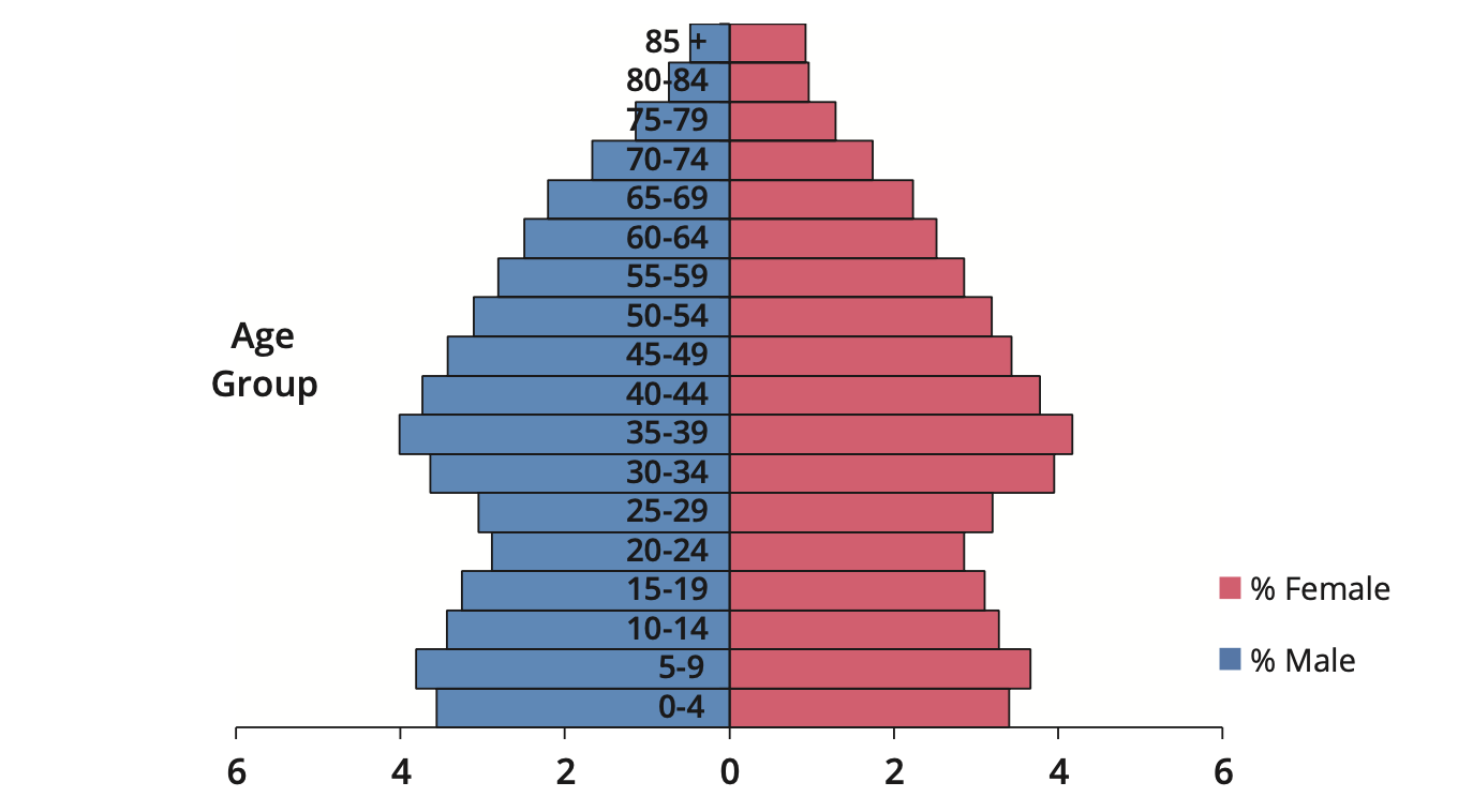
Figure 3.1 Age Structure State 2016
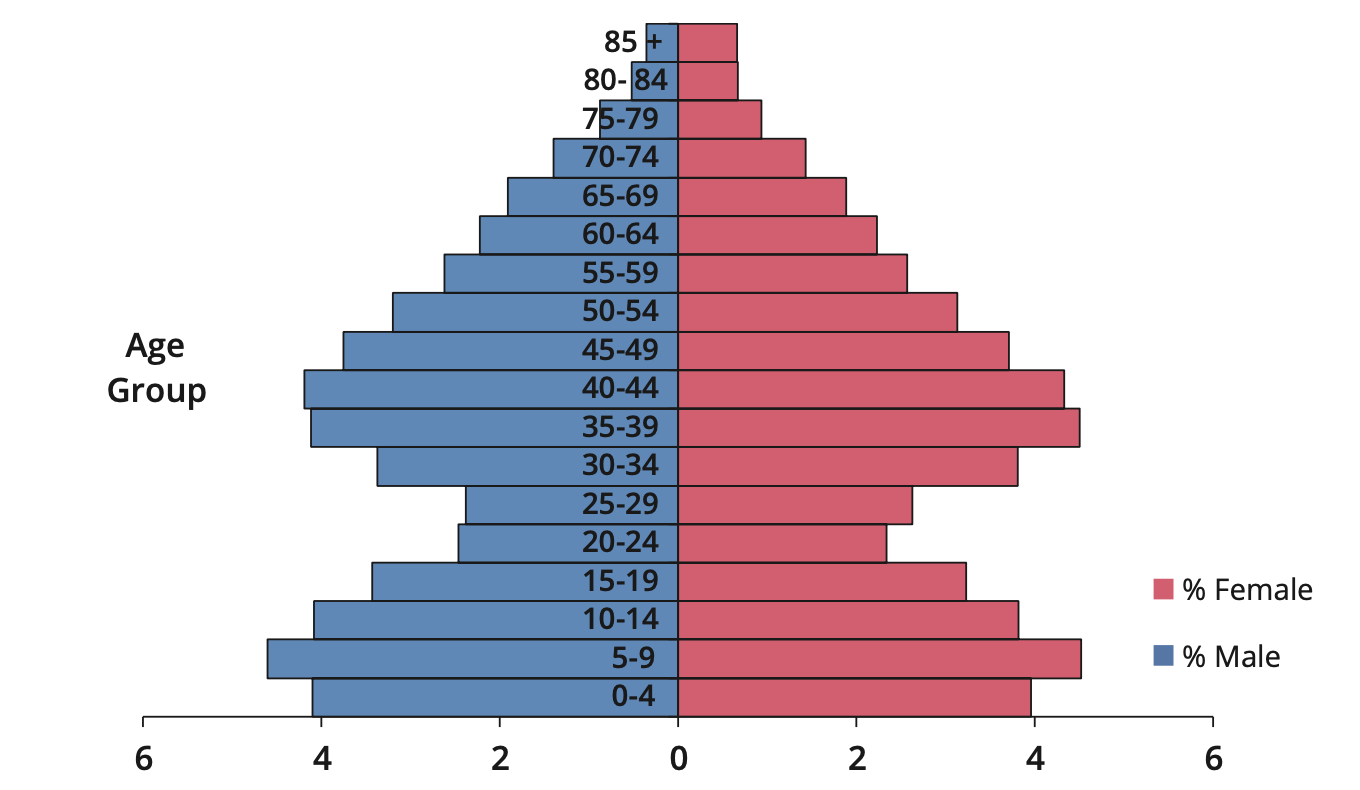
Figure 3.2 Age Structure Meath 2016
3.3.3 Employment
One of the underlying objectives of this Plan is to broaden the economic base of the County and increase employment in order to reduce the volume of outbound commuting and create more sustainable settlements. Whilst it is not uncommon for people to work in a different location than where they live; the distance travelled, the journey time, and mode of transport can have a considerable impact on quality of life and sustainability of the receiving environment at a macro and micro level.
At present there is an imbalance in Meath between the location of jobs and where people live. In 2016 there was a resident workforce of 82,605 persons in the County while the total number of jobs recorded in the County was 50% of this figure at 41,757. This equates to a Job: Resident Workforce of 0.5054, which is confirmation of the high volume of outbound commuting for employment. Some of the key employment statistics for the County are set out in Table 3.3 below.
|
Labour force participation rate |
64.2% |
|---|---|
|
Resident workforce 2016 |
82,605 |
|
Total jobs 2016 |
41,757 |
|
Jobs: Resident Workers 2016 |
0.505 |
|
Outbound commuting 2016 |
55% |
Table 3.3: Key Employment statistics Meath
Census 2016 POWSCAR Data provides useful information at a local level with regard to employment trends in settlements. Figure 3.3 below sets out details of the resident workforce and number of jobs at a Municipal District (MD) level in 2016 whilst Figure 3.4 overleaf provides these details for the key settlements in the County.
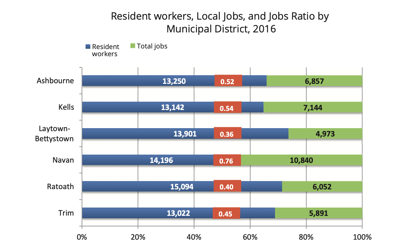
Figure 3.3: Resident workers, Local Jobs, and Jobs Ratio in each Municipal District in Meath in 2016
Whilst the resident workforce in each Municipal District is broadly the same, it is clear that there is a disparity in the location of jobs between each Municipal District. As would be expected, the Navan MD has the highest proportion of jobs. What is of interest is the fact that the Kells MD, which is characterised as being rural in character, has the second highest number of jobs in the County. With 3 of the 6 Municipal Districts in the County having a jobs:workforce ratio of less than 0.5, the dependence on outbound commuting for employment is evident. This is particularly prevelant in the Laytown-Bettystown MD where there is a jobs:workforce ratio of 0.36, which is the lowest in the County.
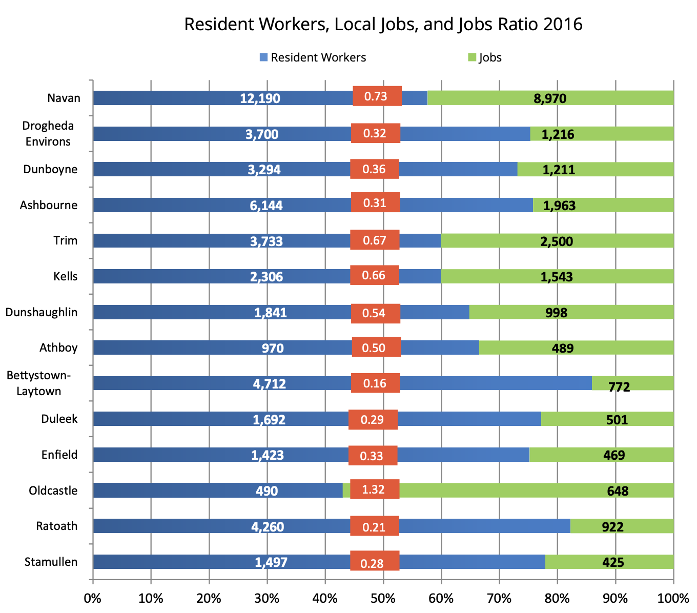
Figure 3.4: Resident workers, Local Jobs, and Jobs Ratio in key settlements in Meath in 2016
An analysis of this data at a settlement level confirms that Navan is the principal employment centre in the County with almost 9,000 jobs located in the town. This equates to 21.5% of the total jobs in the County. With 2,500 jobs and a jobs ratio of 0.67 Trim is the second largest centre for employment in the County.
The importance of Oldcastle as a centre of employment in its wider catchment is evident by the fact that it has a jobs ratio of 1.322. This is the only settlement in the County where there is a net in-flow of workers.
Ashbourne, South Drogheda and Dunboyne have a solid employment base however relative to the resident workforce in these towns the total number of jobs is quite low, resulting in each of these settlements having a jobs ratio of c.0.3. The strategic location of these towns adjacent to and within the Dublin Metropolitan Area (Ashbourne and Dunboyne) and along the Dublin-Belfast Economic Corridor (South Drogheda) provides opportunities to increase employment and economic activity.
The settlements with the lowest jobs ratio are in the southern and eastern parts of the County where there are high volumes of outbound commuting towards Dublin for employment. This includes the East Meath settlements of Bettystown-Laytown-Mornington-Donacarney (Census Town) where the lack of any significant employment base has resulted in the town developing as a commuter settlement. Ratoath is also a settlement where the population has increased in the absence of any significant economic development.
3.4 Settlement Strategy
As part of the ambition to continue to secure economic growth and increased productivity in the County it is essential there is a clear and coherent strategy in place outlining how and where this growth will take place. This Settlement Strategy will support the strengthening of urban structures and networks in the County and the creation of an attractive living and working environment that will make the County an attractive location for economic investment. It also recognises the complementary role of settlements in the County in supporting growth and providing services.
This Strategy will also attempt to address some of the challenges facing towns and villages which include job creation, town/village centre renewal, lack of amenities and services, sustainable transport, and pressure from commuter driven development.
3.4.1 Alignment of Settlement Strategy with the NPF and RSES
Placemaking, compact growth, active land management, and addressing the impact of climate change are some of the key themes of the growth strategy in both the NPF and RSES. There is also an underlying objective to create attractive and ‘liveable’ environments where more people will choose to live.
The Settlement Strategy of this Plan has taken cognisance of these themes and will support the implementation of the National and Regional Strategic Outcomes and Policy Objectives for population and settlement growth set out in the NPF and RSES.
As part of the strategy of aligning the spatial policy with the capital spending programme the Government established an Urban Regeneration and Development Fund (URDF) and a Rural Regeneration and Development Fund (RRDF) under Project Ireland 2040. These Funding Programmes aim to stimulate residential and commercial development in under-utilised lands and areas in towns and villages across the country. They are closely linked to the National Policy Objectives in the NPF with regard to:
- Strengthening urban structures.
- Encouraging population growth in strong employment and service centres of all sizes.
- Reversing the stagnation or decline of smaller urban centres, by identifying and establishing new roles and functions and enhancement of local infrastructure and amenities.
- Addressing the legacy of rapid unplanned growth, by facilitating amenities and services catch-up, jobs and/or improved sustainable transport links to cities, together with a slower rate of population growth in recently expanded commuter settlements.
- Supporting a continuation of balanced population and employment growth in self-contained settlements.
This Plan will follow these principles in its approach to urban development. To assist in the implementation of these policy objectives the Council has successfully obtained funding for various projects under URDF and RRDF which will support urban regeneration, provide additional services and amenities, make town and village centre living more appealing, and make these areas more attractive for private investment.
3.4.1.1 Compact Growth
There is an objective in the NPF and RSES that at least 30% of all new homes will be delivered within or close to the existing built up areas of settlements. The Council acknowledges the social and economic benefits of more compact settlements therefore this Plan will continue to support the sequential approach to the delivery of housing with priority given to infill development and the regeneration of brownfield sites. This will be achieved through an active land management strategy which includes:
- Continued proactive implementation of the Vacant Site Levy.
- The identification of opportunity/under-utilised lands.
- The identification of potential constraints inhibiting the development of zoned lands.
- Ongoing monitoring of the implementation of planning permissions.
3.4.1.2 Sense of place
In addition to achieving compact growth, it is important that a sense of place is created in the local environment that strengthens the connection between people and the place they live and work. This will improve the interaction people have with local amenities, create a local identity, thereby assisting in building a community.
To assist in improving the sense of place in settlements, the Council has embarked on the preparation of a significant programme of public realm plans. It is intended to implement these plans over the life of this Plan.
Further details regarding the public realm and urban design standards are set out in Chapter 11 Development Management Standards and Land Use Zoning Objectives.
3.4.2 Settlement hierarchy
The RSES includes a settlement hierarchy which sets out the settlement structure for the Region. This settlement hierarchy identifies the Regional Growth Centres and Key Towns. The position of the remaining settlements in this hierarchy is to be established in the Development Plan process.
When grouping towns into each ‘Settlement Type’ consideration was given to recent trends in population, employment, and household growth, the level of services available in the settlements, and their ability and appropriateness to accommodate future growth. The settlement hierarchy for Meath is set out in Table 3.4 below.
|
Settlement Type |
Description |
Settlement |
|---|---|---|
|
Regional Growth Centre |
Large towns with a high level of self-sustaining employment and services that act as regional economic drivers and play a significant role for a wide catchment area. |
South Drogheda Environs |
|
Key Town |
Large economically active service and/or county towns that provide employment for their surrounding areas and with high-quality transport links and the capacity to act as growth drivers to complement the Regional Growth Centres. |
Navan |
|
Self-Sustaining Growth Towns |
Towns with a moderate level of jobs and services – includes sub-county market towns and commuter towns with good transport links and capacity for continued commensurate growth to become more Self-Sustaining. |
Dunboyne |
|
Self-Sustaining Towns |
Towns with high levels of population growth and a weak employment base which are reliant on other areas for employment and/or services and which require targeted ‘catch up’ investment to become more self sustaining. |
Laytown/Bettystown/Mornington/Donacarney |
|
Towns and Villages |
Towns and villages with local service and employment functions. |
Towns – Athboy, Oldcastle, Ballivor and Longwood |
|
Rural |
Villages and the wider rural region |
Baile Ghib, Carlanstown, Carnaross, Clonard, Clonee Crossakiel, Donore, Drumconrath, Gormanston, Julianstown, Kentstown, Kilbride, Kildalkey, Kilmainhamwood, Kilmessan, Moynalty, Nobber, Rathcairn, Rathmolyon, Slane, Summerhill |
Table 3.4: Meath Settlement hierarchy
3.4.3 Future Settlement Growth
The primary focus of growth in this Settlement Strategy will be towards the Metropolitan Settlements (Dunboyne and Maynooth Environs), the Regional Growth Centre (Southern Environs of Drogheda), and the Key Town of Navan. The concentration of development in these locations will strengthen the urban structure of the County and support the creation of a critical mass of population in key locations which will assist in creating economies of scale for businesses, investors and infrastructure service providers whilst also providing opportunities to improve the level of community facilities available.
The Self-Sustaining Growth Towns have a solid employment base with capacity to accommodate further expansion. There will be a greater emphasis on achieving a greater balance between employment and population growth in these settlements. Rapidly growing settlements such as Ashbourne, which is the second largest town in the County, will continue to perform an important function in the provision and delivery of services on the edge of the Metropolitan Area.
The Self-Sustaining Towns in the County have experienced rapid population and household growth in the absence of supporting employment, services, and amenities proportionate to this growth. These settlements have developed as commuter towns and remain under considerable pressure for development. The focus in these settlements will be on managing residential growth and ensuring there is a greater emphasis on consolidation and the delivery of employment land and social and physical infrastructure.
The Small Towns and Villages will continue to have an important function in supporting local growth and providing access to local services that will ensure the more rural parts of the County can continue to develop on a sustainable platform.
Chapter 9 of this Plan ‘Rural Development Strategy’ sets out the settlement policy in respect of rural areas in the County, including rural nodes.
3.4.4 Written Statement for each Settlement
As part of this Plan Written Statements and Land Use Zoning Maps have been prepared for all settlements in the Settlement Hierarchy (see Table 3.4).6 The Written Statements and Zoning Maps contained in Volume 2 of this Plan will inform these Local Area Plans.
3.4.5 Local Area Plans
There is a mandatory requirement under section 19 of the Planning and Development Act 2000 (as amended), to prepare a Local Area Plan for the following settlements:
- Navan, The Southern Environs of Drogheda7, Dunboyne, Ashbourne, Kells, Maynooth, Trim, Ratoath, and the census town Bettystown-Laytown-Mornington East-Donacarney
In addition to the mandatory requirements under the Act regarding Local Area Plans, Planning Authorities can also prepare a Local Area Plan for any part of its functional area. In this regard it is also proposed to prepare a Local Area Plan for the following settlements:
- Athboy, Dunshauglin, Duleek, Enfield, Oldcastle, and Stamullen
The reasons a Local Area Plan is to be prepared for these settlements can be summarised as follows:
Athboy is a compact settlement with distinct heritage qualities. A Local Area Plan will provide an opportunity for a detailed strategy to be prepared that will identify specific uses and opportunities that will respect the historical value of the settlement. A public realm plan has been prepared for the centre of the town which will be implemented over the life of this Plan.
Dunshaughlin is a settlement that is presently experiencing significant residential growth primarily due to its connectivity with Dublin via the M3. The settlement has benefitted from recent investments in water and waste water infrastructure. In addition, the town is located along the route of the proposed future rail line to Navan. The Local Area Plan will focus on the facilitating employment growth, the delivery of road infrastructure facilitating access to the M3, and the provision of social and community amenities that will support the development of a balanced and sustainable settlement.
Duleek is an important settlement for enterprise and employment in the eastern part of the County that has the capacity to generate additional employment in the existing business park and facilitate residential growth on a number of infill sites. A detailed analysis of the potential opportunities for Duleek and how any future growth will be co-ordinated will be set out in a Local Area Plan.
Oldcastle is an important employment and service centre in north-west Meath with the highest jobs ratio in the County. The town has a catchment extending into the rural hinterland of Meath and neighbouring counties of Cavan and Westmeath. Oldcastle is a traditional market town with an urban fabric of high-quality. There are significant opportunities for the town to function as a tourism hub given its location proximate to Sliabh Na Calliagh. The Local Area Plan will focus on expanding the employment base of the town that will meet the needs of the local community and surrounding hinterland. A public realm plan is being prepared for the centre of the town which will be implemented over the life of this Plan.
Enfield is located on a multi-modal corridor with excellent road and rail access to Dublin via the M4 motorway and the Dublin-Longford commuter rail line. This infrastructure provides an opportunity to develop the employment base of Enfield based on the principles of sustainable transport provision. A Local Area Plan is required to identify future infrastructural requirements in the town and to set out a coherent growth strategy.
Stamullen is strategically located along the international Dublin-Belfast Economic Corridor. It is a local service centre that performs an important economic function to the local community. A Local Area Plan will focus on strengthening the employment base in the town and improving the accessibility of the town to the M1 via the City North Business Park and identifying a long-term solution to waste water constraints.
3.4.6 Regional Growth Centre
Drogheda has been identified as 1 of 3 Regional Growth Centres in the Eastern and Midland Region in the NPF. It is a settlement with significant growth potential due to its location along the Dublin-Belfast Economic Corridor, the existing service and employment provision in the town, and its capacity to accommodate further growth.
The RSES sets out a strategic framework for Drogheda that will support the continued development of the town and allow it to function as a driver for regional growth. This growth strategy includes a population target of 50,000 for the town by 2031.
The Southern Environs of Drogheda is located in Meath. In 2016 this area had a population of 6,527, which was 16% of the total population (40,956).
In recognition of the importance of preparing a coherent and co-ordinated strategy that will ensure the town can develop to its maximum potential, the RSES requires the preparation of a Joint Urban Area Plan (UAP) for Drogheda by Meath County Council and Louth County Council.8
The RSES recognises the contribution that the Southern Environs of Drogheda can make to the economic development and the creation of a sustainable community due to the availability of enterprise and employment lands in strategic locations close to residential areas.
3.4.7 Key Towns
Key Towns are settlements with a strong employment base and a broad range of services that serve a wide catchment area. Navan has been identified as the Key Town in Meath in the RSES. It is the County town and primary retail and employment centre. In 2016 over 20% of all jobs in Meath were located in Navan.
One of the key objectives of this Plan is to attract further economic investment to Navan in order to strengthen its position as a primary centre for employment in the County. It is recognised that ‘Placemaking’ can make a significant contribution to attracting investment by enhancing the urban environment and improving the interaction people have with the local environment. In this regard, the Council recently published a public realm plan and public transport strategy for the town ‘Navan 2030’ which sets out a strategy for the renewal of the town centre together with public transport improvements. In addition, the Council was successful in a number of funding applications under URDF that will reinvigorate the urban core of the town. This includes the Flowerhill Regeneration Project, Railway Street Regeneration Project and County archive, and a housing focused Active Land Management Project.
Whilst Navan is well connected to Dublin via the motorway network and a frequent bus service, improvements in connectivity are essential to the economic development of the town. There is no rail service to Navan at present, however as part of the 6-year review of the Transport Strategy for the Greater Dublin Area 2016-35, the National Transport Authority has committed to reviewing the requirement for the extension of the railway from the M3 Parkway to Navan in the Transport Strategy for the GDA 2016-35. This commencement of this review has recently advanced with the allocation of funding from the NTA, towards a Feasibility Study for the Rail Line to Navan. The advancement of the delivery of this rail line is a key objective of this Plan. The RSES recognises the importance of this project in the economic development of the town and therefore supports its reappraisal.9
Maynooth is also identified as a Key Town in the RSES. Whilst the town is located within the administrative boundary of Kildare County Council, there are Environs lands along its northern boundary located in County Meath. These lands are considered to be a natural extension to the town.
In order to ensure a co-ordinated approach is undertaken to the future development of Maynooth Regional Policy Objective 4.35 of the RSES requires that a Joint Local Area Plan is prepared by Meath and Kildare County Council.10
The Maynooth Environs lands will be a focal point for employment and complementary residential uses. The development of these lands will facilitate the delivery of the Maynooth Outer Relief Road (MOOR) which is strongly supported in the RSES. This is a critical piece of infrastructure in the future growth and development of Maynooth.
3.4.8 Self-Sustaining Growth Towns
Self-Sustaining Growth Towns are those settlements that have a solid employment base and a broad range of services and have the capacity to accommodate additional growth on a sustainable platform.
There are 5 settlements in the County identified in this category; Dunboyne, Ashbourne, Kells, Trim, and Dunshaughlin. The Metropolitan settlement of Dunboyne is a strategically important settlement in Meath. It is an important centre for economic growth in the County due to its location in the Dublin Metropolitan Area and along a multi-modal corridor. The town has enjoyed recent successes in attracting inward investment. It is an objective of this Plan to continue to attract high-quality investment to the town. In addition, there is capacity for the town to accommodate significant population growth, with strategically located lands zoned for residential use in proximity to the rail stations available for development.
Ashbourne is the second largest town in the County. The rapid expansion of the town from a small village to a large urban centre is primarily related to its proximity to Dublin Airport and Dublin City Centre. The completion of the new town centre development in Ashbourne has significantly improved the retail provision in the town.
Employment and enterprise in Ashbourne benefits from its proximity to Dublin Airport, its strong links with the Dublin Metropolitan Area, and its location along the N2 strategic road corridor. As Dublin Airport continues to expand it is anticipated that the strategic importance of Ashbourne as a place of employment in Meath and the wider region will increase. This Plan identifies the strategic importance of Ashbourne and will support and facilitate industry, employment, and enterprise in the settlement as it continues its transition to a Metropolitan Centre.
As part of the future growth strategy for Ashbourne and to improve connectivity with Dublin City Centre it is an objective of this Plan to explore the feasibility of providing a rail link to Ashbourne as part of Phase II of the Navan Rail Project11.
Kells and Trim have a unique cultural and built heritage and are accordingly designated heritage settlements. They are important tourist destinations in the County. Both settlements have strong links with the principal economic centre of Navan. Kells is an important centre for local enterprise and employment. The designation of the Kells Municipal District as a Regional Economic Development Zone (REDZ) has had a positive impact on employment and enterprise activity in the town.
With a ‘Jobs:Resident Workforce’ ratio of 0.67 and 2,500 jobs in 2016, Trim is the second largest centre for employment in the County behind Navan. It is an objective of this Plan to continue to maximise the number of local job opportunities in Trim during the life of this Plan. It will also support the investment in and expansion of the tourist product in the town.
Dunshaughlin is an important growth town in south Meath that benefits from strong road links to Dublin due to its proximity to the M3. Whilst there is a frequent bus service to the capital the car remains the predominant mode of transport. The town has a strong employment base with potential for future expansion. The population growth of the town would support the delivery of the Navan rail project as it would provide a critical mass of population along the rail line. The delivery of this rail project is a key element in supporting the sustainable growth of the town.
The town is in the unique position of having benefitted from significant investment in water and waste water infrastructure. The front loading of these services alongside upgrades to the local network has created significant capacity in this infrastructure to accommodate medium-long-term growth.
Residential activity in Dunshaughlin is buoyant with a significant number of active residential sites in the town at the time of writing. In addition, An Bord Pleanala granted a Strategic Housing Development for 913 residential units on the northern side of the town in April 2019. Future development in Dunshaughlin will focus on the completion of existing developments currently under construction and the build out of the units granted under the Strategic Housing Development. In addition, support will be given to the creation of additional employment opportunities in the town alongside necessary services to ensure the development of the town takes place on a sustainable platform. Additional local road infrastructure will be required to address localised access issues and in particular securing a more direct link to the M3 Motorway.
3.4.9 Self-Sustaining Towns
The Self-Sustaining Towns in the County vary in size, built form, and service provision. The location of these settlements has influenced their growth rate and function. The settlements in the commuter area of Dublin have experienced higher levels of growth and have the characteristics of dormitory settlements due to the high levels of outbound travel for employment. Growth in the more peripheral settlements has been largely based on local growth.
Ratoath, Bettystown-Laytown-Mornington East-Donacarney (East Meath), Enfield, Kilcock, Duleek and Stamullen have all developed on the basis of outbound commuting to Dublin. The highest levels of growth have been in Ratoath and the East Meath settlements. Social and physical infrastructure and employment provision in these settlements has struggled to keep pace with population growth.
Whilst Duleek has experienced commuter-led residential development, employment in the town has also grown through the expansion of the Business Park. The continued expansion of the Business Park will be encouraged in order to provide a greater proportion of employment locally, consistent with the settlement's role as a self-sustaining town proximate to a regional growth centre.
Future development in these settlements will generally be focused towards local growth with appropriately sized employment and enterprise encouraged in order to assist in the creation of more sustainable communities. A strategic employment site has been identified in Laytown adjacent to the train station in order to provide a focus for addressing the employment deficiencies in this area.
Ratoath received LIHAF funding to assist in the delivery of a section of the Outer Relief Road. This section of road is currently under construction and when completed will facilitate the release of lands for residential development in the south-eastern part of the town.
The completion of this Outer Relief Road has been a Local Area Plan objective for a number of years. There is an opportunity to maximise the investment in this LIHAF funded infrastructure by facilitating the completion of this Outer Relief Road and complete the link between the R125 and R155. This will be achieved by zoning additional lands for residential development and requiring that the remainder of this link road is delivered as part of the development of these lands.
There is also an opportunity to provide additional employment opportunities in Ratoath by supporting the integration of existing major equestrian facilities with the town. To facilitate such economic investment a strategic employment site has been identified and will be strongly promoted from an economic and employment creation perspective.
In general, it is envisaged that growth in the Self-Sustaining Towns will expand at a sustainable rate in line with the availability of local services and infrastructure. Employment and economic opportunities will be supported at appropriate locations where they are of a nature and scale proportionate to the size and service availability in the town. Retail development will be primarily in the convenience category, with small supermarkets and local centres serving the town and its local catchment area only.
3.4.10 Towns and Villages
Below the Self-Sustaining Towns are towns that are experiencing lower levels of population growth that are primarily based on locally based growth. These towns perform important employment and service functions in their surrounding area.
Athboy and Oldcastle are important service centres in the western parts of the County. Athboy has a strong retail base that serves an extensive hinterland. It is also an important centre for local employment and community activities.
Oldcastle is a historic market town that has a strong tradition in the manufacturing industry that includes furniture and engineering. Another important employment sector in the town is the service industry. Similar to Athboy, Oldcastle has an extensive catchment that stretches into the neighbouring counties of Cavan and Westmeath.
The Villages in the County vary in size with a population ranging from c.200 to in excess of 1,000 people. They provide important local community and retail services with smaller scale rural enterprises also present in a number of villages. The level of service and catchment population of the villages is smaller than that of the towns further up the settlement hierarchy.
The future development of these villages will be focused on organic growth only that primarily serves the local population. There will be a strong emphasis on brownfield and infill development delivering this growth. Any development in villages, within commuting distance of Dublin, will be managed so as to avoid unsustainable travel patterns. These are primarily the villages in the south and east of the County including Rathmoylon, Donore, Julianstown, Clonard, and Kentstown.
In the more remote areas of the County there are key villages that perform a more important function due to their distance from the larger settlements. These villages operate as rural service centres and have a vital role in sustaining rural communities. Such villages include Carlanstown, Rathcairn, and Baile Ghib. This Plan will support locally based services and enterprise in these villages whilst residential development shall meet the needs of local growth.
In order to retain the distinct character of these villages, any future development shall be of a character and scale reflective of the village in question.
The villages of Baile Ghib and Rathcairn are the only Gaeltacht settlements in the County. Any future development in these adjacent villages shall reflect the distinctive character of these areas and will support the Irish language. Further details are contained in Chapter 9 Rural Development Strategy and Volume 2.
Below Villages in the Settlement Hierarchy are Rural Nodes. The strategy for Rural Nodes is set out in Chapter 9, Rural Development Strategy12.
3.5 Tiered Land Use Zoning
The NPF advocates close co-ordination between infrastructure agencies and Planning Authorities when zoning land for development. This will result in a standardised methodology that will differentiate between zoned land that is available for development and zoned land that requires significant further investment in services and infrastructure for development to be realised.13 This two tier approach to land zoning is as follows:
|
Tier 1: Serviced Zoned Land |
|
These are lands that are either serviced or can connect to existing services. |
|
Tier 2: Serviceable Zoned Land |
|
These are lands that are not currently sufficiently serviced to accommodate new development but have the potential to become fully serviced during the life of the Plan |
It is anticipated that further guidance on this approach to land use zoning will be set out in detail in the updated Development Plan Guidelines for Planning Authorities.14
An analysis of all undeveloped lands zoned for employment and residential uses in each settlement to identify any potential infrastructure constraints inhibiting lands from being developed has been carried out.
3.6 Land Use Zoning in each settlement
A Land Use Zoning Map has been prepared for each settlement included in the settlement hierarchy. These maps illustrate the location and extent of zoned lands in each settlement.
The quantum of lands zoned for residential uses is reflective of the population projection and household allocation for each settlement as set out in the Core Strategy.
In settlements where a surplus of residential land remains, lands have been prioritised based on their location, the availability of services, and the likelihood of the lands being developed within the lifetime of the Plan. A reserve of residential lands not available for development until after 2027 has been provided in settlements where there are fundamental reasons, supported by national and regional policy that would support the requirement to phase such lands. These ‘Post 2027’ lands have been identified in Dunboyne, Navan, Dunshaughlin, Enfield and Kilcock Environs.15
Through the implementation of the active land management strategy with particular reference to the Vacant Site Levy, the Council will be supporting promoting the regeneration/development of infill and brownfield site and the development of key strategic green field sites.
Whilst the Council advocates a sequential approach to development this is not always possible due to lands not being brought forward for development. This can lead to instances where there are strategically located sites close to town centres and public transport remaining undeveloped. There are various reasons for such lands not being developed including lack of impetus from land owners, lack of finance, and infrastructure deficits.
This presents a challenge for the Council with regard to quantifying the residential land requirement for the particular settlement. The RSES recognises that there are instances where such strategic sites are not being brought forward for development and recommends that Planning Authorities should not place an “unreasonable dependency” on these lands delivering development where this would impede other suitable lands with more prospect of being developed in the short term.16
In settlements where there are challenges in releasing such strategic lands, the Council will continue to support the development of these lands through its active land management strategy. In instances where this has arisen, the quantum of residential lands identified for development has taken account of the fact that certain lands may not be developed during the life of the Plan in order to ensure there are sufficient lands, likely to be brought forward for development, to meet the projected population growth.
3.7 The Settlement Hierarchy and Future Population Growth in Meath
The Settlement Strategy in this Plan is consistent with the approach set out in the NPF and RSES in that it will encourage consolidation of existing urban centres with an emphasis on delivering more compact growth. It supports the creation of sustainable ‘live work’ communities whilst also maximising on recent investment in physical and social infrastructure. The larger settlements at the top of the settlement hierarchy will receive the greatest proportion of growth, with development in smaller towns and villages primarily focused on local growth.
An emphasis on the consolidation of growth in the Metropolitan Area is also a key element of this Strategy, with 14.5% of the total population growth to be directed to the Metropolitan Area.
Navan, the Southern Environs of Drogheda, and Dunboyne are strategically located settlements within the County and are important centres for enterprise and employment. These settlements have the potential to make a significant contribution to the delivery of housing in the County in the medium term with a substantial quantity of “ready to go” serviced lands available for development. An example of such lands is in the Farganstown area of Navan where LIHAF funding will support the delivery of up to 1,600 residential units in the long-term.
An incremental, sequential approach will be taken to the development of these settlements that will support the long-term objective of achieving a population of 50,000 in Navan and Drogheda and 25,000 in Dunboyne.
The future expansion of the Self-Sustaining Growth Towns other than Dunboyne will be more moderate than Navan and Drogheda and will focus on the delivery of social and physical infrastructure in tandem with residential growth and employment. Ashbourne and Dunshaughlin are two Self-Sustaining growth settlements that have the capacity to absorb further growth.
Ashbourne’s link to Dublin Airport and Dublin City Centre provides a solid basis for the settlement continuing to expand. There will be a stronger emphasis on the provision of employment and necessary social and physical infrastructure with any continued residential growth.
Dunshaughlin is strategically located along the route of Phase II of the Dublin-Navan Rail Line. In this regard, it is considered appropriate to provide for the future growth and expansion of the town on the basis that it will be located along a sustainable rail based corridor in the future. Dunshaughlin has also benefitted from recent upgrades in water and wastewater infrastructure that will facilitate future population and employment growth.
In the Self-Sustaining Towns there will be a strong focus on consolidation and strengthening the employment base and improving services which will support the creation of more balanced and sustainable communities.
The level of growth in the Towns and Villages will be primarily focused on local growth proportionate to the size of the settlement rather than commuter driven development. The consolidation of these settlements will provide a greater focus on the provision of necessary services that would facilitate the creation of sustainable communities. Residential development in these settlements will be modest in scale and will have regard to the scale of existing development in the settlement.
Settlement Strategy Policies
It is the policy of the Council:
SH POL 1
SH POL 2
To promote the consolidation of existing settlements and the creation of compact urban forms through the utilisation of infill and brownfield lands in preference to edge of centre locations.
SH POL 3
To support the creation of healthy and sustainable communities that encourages and facilitates walking and cycling and general physical activity through the implementation of best practices in urban design that promotes permeability and interconnecting spaces.
Settlement Strategy Objectives
It is an objective of the Council:
SH OBJ 1
To secure the implementation of the Core Strategy and Settlement Strategy, in so far as practicable, by directing growth towards designated settlements, subject to the availability of infrastructure and services.
SH OBJ 2
To ensure that sufficient zoned lands are available to satisfy the housing requirements of the County over the lifetime of the Plan.
SH OBJ 3
To ensure the implementation of the population and housing growth allocations set out in the Core Strategy and Settlement Strategy.
SH OBJ 4
To operate an Order of Priority for the release and development of residential lands with any lands identified as being ‘Post 2027’ not being available for residential development during the lifetime of the subject development plan and no permission for dwellings will be granted on these lands by Meath County Council.
SH OBJ 5
To prepare new local area plans for the following settlements within the lifetime of this Plan: Navan, Dunboyne/Dunboyne North/Clonee, Ashbourne, Kells, Trim, Dunshaughlin, Ratoath, Enfield, Bettystown-Laytown-Mornington East-Donacarney-Mornington (East Meath), Oldcastle, Athboy, Duleek, and Stamullen. As part of the preparation of these Plans, a detailed infrastructure assessment, consistent with the methodology for a Tiered Approach to Zoning under Appendix 3 of the NPF will be undertaken for each settlement.
SH OBJ 6
The existing Southern Environs of Drogheda Local Area Plan 2009 (The LAP) shall remain the statutory plan for the Southern Environs of Drogheda until such a time as it is replaced with a Joint Urban Plan for Drogheda in conjunction with Louth County Council having regard to the requirements of the Report of the Drogheda Boundary Review Committee (February 2017), the National Planning Framework, and the Eastern and Midland Region Regional Spatial and Economic Strategy (2019-2031). This plan shall be read together with the County Development Plan 2021-2027. The County Development Plan 2021-2027 shall take precedence if a conflict arises between the Plans and the conflicting provision of the LAP shall cease to have effect.
SH OBJ 7
To prepare a Joint Vision and Urban Area Plan for Drogheda in partnership with Louth County Council within the lifetime of this Plan in accordance with the requirements of Regional Policy Objective 4.11 of the RSES for the Eastern and Midland Region.
SH OBJ 8
To prepare a Joint Vision and Local Area Plan for Maynooth in partnership with Kildare County Council within the lifetime of this Plan in accordance with the requirements of Regional Policy Objective 4.35 of the RSES for the Eastern and Midland Region.
SH OBJ 9
To develop Navan and the Southern Environs of Drogheda as the primary development centres in Meath and to continue to promote Dunboyne as a key settlement in the Metropolitan Area of Dublin. The long-term growth of these settlements shall be based on principles of balanced and sustainable development that support a compact urban form and the integration of land use and transport.
SH OBJ 10
To ensure that in Villages no single application on a defined parcel of land shall increase the existing housing stock by more than 15%.
SH OBJ 11
To continue to support the sustainable development of Ashbourne by supporting its development as an enterprise and employment hub and by strengthening links and connectivity between Ashbourne and Dublin Airport and City Centre and the wider Metropolitan Area.
SH OBJ 12
Where appropriate, serviced sites may be accommodated within existing zoned residential land or on lands immediately adjoining the development boundary of Tier 5 and Tier 6 towns/villages, subject to normal planning considerations.
3.8 Housing
3.8.1 Introduction
The delivery of housing in the appropriate location and the creation of attractive neighbourhoods with a range of housing options and a strong sense of place and community are key objectives of this Plan.
It is recognised that the availability and supply of housing to meet the required demand is a critical element in maintaining the competitiveness of the County and its attractiveness as a place to live and invest.
This section of the Settlement Strategy sets out the framework for the provision of housing over the lifetime of the Plan.
3.8.2 Challenges in the Delivery of Housing
One of the consequences of the recession was a dramatic decline in the output of housing, particularly in urban areas where a demand has remained. Following a prolonged period of undersupply there is a ‘pent up’ demand for housing, which has resulted in increased house prices, rents, and homelessness across the country. The Government has responded to these challenges with legislative changes and policy initiatives which are intended to stimulate development and increase the supply of housing.
3.8.2.1 Legislation changes and Policy Initiatives.
The Urban Regeneration and Housing Act 2015 resulted in significant changes to the social housing requirement under Part V of the Planning and Development Act 2000, as amended. This included the removal of the options for developers to fulfil Part V obligations by making a financial contribution or making land available outside the development site. The social housing obligation was lowered from 20% to 10% for developments of 10 or more units. A Vacant Site Levy was also introduced under this legislation. A Housing Action Plan ‘Re-Building Ireland – An Action Plan for Housing and Homelessness’ was published in 2016. This set out a series of measures and targets by the Government that aims to increase and accelerate the delivery of housing across the country. There is a target to double the annual level of construction to 25,000 units by 2020 and to deliver 47,000 units of social housing up to 2021.
In order to assist in the delivery of these units a Local Infrastructure Housing Activation Fund (LIHAF) was established. This is a €200 million fund that will contribute towards the construction of critical public infrastructure required to deliver housing on key development sites across the country. The Council has received funding for the construction of a Distributor Road in Navan that will release lands with a potential to deliver 1,600 units and a section of an Outer Relief Road in Ratoath that will open up lands with a potential to deliver 370 units.
In recognition of the continued increase in rental properties Rent Pressure Zones have been identified in areas where rents are above average national rent level or have experienced significant rental inflation in excess of 7% in four of the last six quarters. The legislative requirements for designating a Rent Pressure Zone are set out in the Residential Tenancies Act 2004 (as amended).At the time of writing all Local Electoral Areas in Meath (i.e. the entire County) have been designated as a Rent Pressure Zone.17
Within areas designated as a Rent Pressure Zone legislation has been introduced requiring planning permission where a person intends to let their property for short-term letting purposes.18
As part of a strategy of streamlining the planning process to speed up the delivery of housing the Planning and Development (Housing) and Residential Tenancies Act 201619 introduced, for a limited period, arrangements for fast track planning applications for strategic housing developments (SHDs) of 100 or more housing units, student accommodation of 200 or more bed spaces, or shared accommodation developments of 200 or more bed spaces, to be made directly to An Bord Pleanala for determination.
The Design Standards for New Apartments were updated in 2018, with the amendments striving to enable a mix of apartment types, make better provision for building refurbishment and infill schemes, and address the emerging ‘build to rent’ and ‘shared accommodation’ sectors.
Rebuilding Ireland seeks to improve the rental sector by striving to make rent more affordable and creating an attractive, viable, and sustainable private rented sector. As part of this strategy ‘Build to Rent’ and ‘Shared Accommodation’ have emerged.
‘Build to Rent’ developments are large scale developments that have the potential to deliver residential accommodation at a pace and scale significantly greater than that of the more traditional developers.
‘Shared accommodation‘ or ‘Co-Living’ consists of professionally managed rental accommodation where individual rooms are rented within an overall development that includes access to shared or communal facilities and amenities.
The Urban Development and Building Heights Guidelines for Planning Authorities published in 2018 build on the strategic policy framework set out in the NPF which supports higher densities and more compact urban growth.
3.8.2.2 Housing supply in Meath
In recent years, housing output in the County is showing signs of normalisation, with year on year increases in the number of completed units. It is important that ongoing completion numbers are monitored in light of the potential economic slowdown arising from the Covid 19 pandemic.
3.8.3 Meath County Housing Strategy
The preparation of a Housing Strategy is a mandatory requirement under Part V of the Planning and Development Act 2000, as amended. The purpose of a Housing Strategy is to evaluate the housing needs of the existing and future population in the County.
National Policy Objective 37 of the NPF requires a Housing Need Demand Assessment (HNDA) to be carried out for each Local Authority Area.20 This assessment will evaluate the number of additional housing units required to meet existing and future demand. At the time of writing this Plan no guidance documents or relevant data or associated projections has been provided to assist Local Authorities in the preparation of a HNDA. Until these guidance documents become available the Housing Strategy will continue to inform Housing Policy in the County.
The Meath County Housing Strategy is closely aligned with the Core Strategy in that the future housing need is based on the population and household projections outlined in the Core Strategy. The Strategy is also informed by the most recent Social Housing Needs Assessment for Meath in addition to National Housing Policy publications including ‘The Social Housing Strategy 2020 – Support, Supply, and Reform (2014)’, and ‘Rebuilding Ireland – Action Plan for Housing and Homelessness (2016)’.
The Strategy includes an analysis of housing requirements in the context of affordability and addresses the need to ensure that housing is available for persons with different levels of income. It also assesses the mix of house types and sizes (including accommodation for the elderly and persons with disabilities) and highlights the need to counteract undue segregation in housing between persons of different social backgrounds.
The Housing Strategy estimates that there will be a requirement for 1,397 social and affordable units between 2020 and 2026.
The mechanisms for delivering social housing include the following:
- Part V of the Planning and Development Act 2000 (as amended).
- Direct construction by Local Authorities or in partnership with Approved Housing Bodies (AHBs).
- Rental Accommodation Scheme (RAS), Social Housing Lease Initiatives and Housing Assistance Payments (HAPs).
- Purchase of new or second-hand residential units.
- Casual vacancies.
The full version of the Housing Strategy can be found in Appendix 4 of this Plan. A review of the Housing Strategy will be carried out as part of the mandatory Two Year Development Plan review.
The Council is seeking to prioritise the delivery of social housing in a number of settlements where a combination of high demand, limited and/ or no suitable land in Council ownership and difficulties in acquisition of land are all factors inhibiting supply. Taking this into account an objective supporting the delivery of social housing in addition to that required by Part V will be included in the Written Statement for Ashbourne, Dunboyne, Dunshaughlin, Ratoath, and Trim in Volume 2 of this Plan.
Housing Strategy Policies
It is the policy of the Council:
SH POL 4
To promote social integration and the provision of a range of dwelling types in residential developments that would encourage a mix of tenure, particularly in any State funded house building programmes.
SH POL 5
To secure a mix of housing types and sizes, including single storey properties, particularly in larger developments to meet the needs of different categories of households.
SH POL 6
To support the provision of accommodation for older people and for people with disabilities that would allow for independent and semi-independent living in locations that are proximate to town and village centres and services and amenities such as shops, local healthcare facilities, parks and community centres.
Housing Strategy Objectives
It is an objective of the Council:
SH OBJ 13
To secure the implementation of the Meath Housing Strategy 2020-2026.
SH OBJ 14
To support the delivery of social housing in Meath in accordance with the Council’s Social Housing Delivery Programme and Government Policy as set out in Rebuilding Ireland: Action Plan for Housing and Homelessness.
SH OBJ 15
To apply a 10% social housing requirement, pursuant to Part V of the Planning and Development Act 2000, as amended, to land zoned for residential use, or for a mixture of residential and other uses, except where the development would be exempted from this requirement.
SH OBJ 16
To address the identified need to increase the supply of social housing in Trim,Ashbourne, Ratoath, Dunboyne, Dunshaughlin by seeking the provision of social housing additional to that required by way of Part V of the Planning and Development Act 2000 as amended, subject to funding.
SH OBJ 17
To review the Housing Strategy two years after the adoption of the Development Plan as part of the mandatory Two-Year Development Plan review.
SH OBJ 18
To implement the ‘Meath County Council Traveller Accommodation Programme 2019-2024’ and any subsequent programme adopted during the lifetime of the Development Plan.
SH OBJ 19
To support the provision of accommodation that would satisfy the requirements of people with a disability and the implementation of the ‘Strategic Plan for Housing Persons with Disabilities 2016-2019’ and any subsequent Plan adopted during the lifetime of the Development Plan.
SH OBJ 20
To support the implementation of the Mid-East Regional Homeless Action Plan 2018-2020 and any other subsequent Homeless Action Plans adopted during the lifetime of the County Development Plan.
3.8.4 Vacant Site Levy – Residential and Regeneration Lands
Construction 2020, published in 2014, focused on facilitating increased activity in the construction sector, and in particular residential construction, in order to meet the demand for housing and contribute to the economic recovery. Action 23 of this Strategy focused on how to incentivise the use of vacant and underutilised sites in urban areas.
This culminated in the publication of the Urban Regeneration and Housing Act in 2015 which provided for the introduction of a Vacant Site Levy. The intention of this levy is to incentivise the development of vacant sites in urban areas for residential and regeneration purposes.
The levy will support the implementation of the Development Plan and Core Strategy objectives, particularly in respect of promoting the renewal and regeneration of urban areas, ensuring a compact urban form and sustainable growth patterns, and in achieving the household allocations and meeting the housing needs of the County.
The Urban Regeneration and Housing Act set out two broad categories of vacant land that the levy may apply to:
- Lands zoned primarily for residential purposes
- Lands in need of regeneration
3.8.5 Lands zoned for residential purposes
The following zonings will be applicable to the ‘residential’ category:
- A1 ‘Existing Residential’
- A2 ‘New Residential’
- B1 ‘Commercial/Town or Village Centre’
- C1 ‘Mixed Use’
3.8.6 Lands in need of regeneration
It is an objective of this Plan to support the regeneration of land and buildings. For the purposes of this Plan the ‘Regeneration’ lands, as defined under the Urban Regeneration and Housing Act 2015, applies to the following zonings:
- B1 ‘Commercial/Town or Village Centre’
- C1 ‘Mixed Use’
The implementation of the Vacant Site Levy requires the Council to identify sites in the County which are vacant and come within the scope of the Urban Regeneration and Housing Act 2015 (as amended). Any sites identified are to be entered on a Vacant Sites Register that is to be monitored by the Council. The amount of the Vacant Site Levy is set out in section 16 of the Urban Regeneration and Housing Act 2015 (as amended) and shall be equal to 7% of the market value of the site for 2019 and subsequent years (unless otherwise revised).
At the time of writing there were 18 sites on the Vacant Sites Register in Meath.21 The Register can be viewed by clicking on this link.
Vacant Site Levy Objective
It is an objective of the Council:
SH OBJ 21
To promote the development of vacant residential and regeneration sites in all development centres in the County, as appropriate, in accordance with the requirements of the Urban Regeneration and Housing Act 2015 (as amended).
3.8.7 Sustainable Communities
The Institute of Sustainable Communities defines a sustainable community as one “that is economically, environmentally, and socially healthy and resilient.”22
Common elements of a sustainable community include:
- Healthy and safe surroundings in which the needs of everyone are met.
- A strong economy with employment opportunities.
- An environment that is appreciated.
The creation of a sustainable community can be achieved through well designed buildings and spaces, which promote social interaction, ensure ease of access, and create an open and safe environment. An attractive and well-maintained environment also creates a sense of identity that promotes a sense of community in a local neighbourhood.
This Plan continues to promote the development of sustainable communities by supporting a suitable mix of housing units, services, employment, community facilities, and associated infrastructure in appropriate locations.
A key element of a sustainable community is the provision of social and recreational amenities. As the population of settlements increase, existing facilities can sometimes struggle with the associated increased demands on these amenities. In order to ensure there is an appropriate provision of such facilities and amenities, it is a requirement of this Plan that a Social Infrastructure Assessment is included with planning applications for the development of 50 units or more. This Assessment will be required to determine whether or not existing social and recreational facilities are sufficient to cater for the needs of the future residents of the development. (Please refer to Chapter 7 Community Building Strategy for full requirements in respect of Social Infrastructure Audit).
3.8.7.1 Live Work Communities
As part of the spatial implementation of the Economic Development Strategy 2014-22 the Council has piloted and targeted the creation of ‘live-work’ communities in designated towns at the upper end of the settlement hierarchy. This is a more integrated approach to settlement growth which promotes the location of employment close to residential areas and services such as schools and shops. Dunboyne North and Farganstown in Navan are two examples of locations in the County where the Council is supporting the delivery of the ‘live work’ community model.
As stated, these ‘live work’ communities are targeted particularly towards the larger settlements in the County. There are a number of benefits to the implementation of this model, some of which are as follows:
- A reduced travel time to work which results in people having more time to participate in local activities, which improves the level of social interaction and the sense of community in settlements.
- Improved health and quality of life. If people are working near their home they are more inclined to walk/cycle to work and participate in other physical activities.
- Fewer cars travelling long distances reduces congestion which benefits the environment and reduces the carbon footprint of the County.
By providing a mix of house types in these communities there is a greater capacity for people to buy a house that suits their needs and will allow people to live in the same neighbourhood through all stages of life, if they so desire. The ‘Live work’ development model is fully supported in the RSES.
3.8.8 Housing for Older People
With people living longer it is important that provision is made to allow older people to live independently in their local community for as long as possible. Living close to local services and facilities creates a convenient lifestyle for older people and encourages them to remain active and healthy. The Council has published an ‘Age Friendly Strategy 2017-2020’, which seeks to cater for the needs of older people.
This Plan supports the provision of a mix of house types that provide a choice for older people and encourages private developers to incorporate the principles of universal design into new residential properties. Consideration should be given to providing single storey properties in large residential developments that would provide older people with the option of downsizing if so desired. This would have the positive knock on effect of releasing larger homes for younger families.
The adaption of existing homes to meet the changing needs of older people is also supported. It is recognised that there are opportunities for infill development in central locations in established urban areas to meet the housing needs of older people. Such development will be encouraged, subject to the appropriate standards being met.
3.8.8.1 Housing for People with Disabilities
The delivery of housing for people with disabilities requires co-ordination between design teams and community support networks in order to ensure specific housing needs are met.
The Council provides accommodation for disabled people through various means including the adaption of existing housing stock and the construction of specially designed units, subject to adequate funding and resources being available.
The Council published a ‘Strategic Plan for Housing Persons with Disabilities’ in 2016. This Strategy aims to provide an appropriate range of housing and support services that will meet the needs of persons with disabilities. This Plan will support the implementation of this Strategy.
3.8.8.2 Traveller Accommodation
The Council Traveller Accommodation Programme 2019-2024 outlines the Council Policy regarding the provision of Traveller Accommodation. It sets out the range of social housing supports for Travellers including standard Local Authority Housing, Approved Housing Body Housing, Group Housing and Halting Site Bays.
Provision has been made for two Group Housing Schemes in Navan consisting of eight and six-unit schemes and one Group Housing Scheme in Trim consisting of six units.
The Programme also identifies that the existing Halting Site at St. Francis Park in Navan is under-utilised. The Council is presently seeking funding from the DHPLG for the refurbishment of this site which will allow for full occupancy.
3.8.9 Design Criteria for Residential Development
Well-designed residential developments can make a significant contribution to the creation of an attractive urban environment where people want to live, work, and socialise.
Applications for new residential developments should strive to create a sense of place by responding positively to local surroundings. This can be achieved by taking into account local building types and styles, landmark buildings, and any important views or features in the local landscape. Innovative designs that would not compromise the local environment are encouraged.
New buildings should be designed to take account of the potential implications of climate change including higher temperatures, different rainfall patterns and a potential increase in extreme events such as flooding and storms. Improving the energy efficiency of buildings would reduce energy consumption and therefore reduce greenhouse gas emissions.
New developments should include a suitable mixture of house types that will support the creation of a sustainable community. The principles of good urban design should be embraced. This includes the creation of permeable streets that promote walking and cycling and provide direct and safe routes to adjoining developments and town/village centres in accordance with the principles and recommendations set out in the Design Manual for Urban Roads and Streets (DMURS). Public realm and open spaces should be of a high-quality and design that benefits all residents, whilst measures should also be taken to ensure the creation of a safe and secure environment that would minimise any opportunities for anti-social behaviour and promote the use of high-quality finishes to buildings and boundaries.
The principles of universal design that support the optimal design and layout of buildings and neighbourhoods that cater for all age groups, and the promotion of energy efficiency to improve the environmental performance of buildings and the integration of renewable technologies into the design of new buildings is also encouraged. This concept of providing lifetime adaptable homes is a policy objective of the NPF.
The following guidance documents are useful reference points in relation to the design and layout of residential developments:
- The Guidelines on Quality Housing for Sustainable Communities, DEHLG (2007)
- The Guidelines for Planning Authorities on Sustainable Residential Development in Urban Areas, DEHLG (2009)
- Urban Design Manual: A Best Practice Guide, DEHLG (2009)
- Sustainable Urban Housing: Design Standards for New Apartments, DHPLG (2018)
- The Design Manual for Urban Roads and Streets, DTTAS and DECLG (2013 and updated in 2019)
- Permeability Best Practice Guide, NTA (2015)
Further details of the standards and requirements for residential developments are set out in Chapter 11 ‘Development Management Standards and Land Use Zoning Objectives’.
3.8.10 Densities
Building at higher densities makes more efficient use of land and allows for a more compact form of development that supports and maximises investment in critical infrastructure such as public transport..
This Plan seeks to maximise the use of serviced residential lands and promotes the creation of compact, high-quality developments, with higher densities supported in appropriate locations.
Density policy is informed by the Guidelines for Planning Authorities on ‘Sustainable Residential Development in Urban Areas’ (2009) and the National Planning Framework, which supports higher densities in city and town centres and along public transport corridors through mechanisms such as reduced vacancy rates, infill development and the regeneration of centrally located lands.
It is an objective of this Plan to require a density of 45 units/ha on more centrally located and strategic lands in Regional Growth Centres and Key Towns. This density is also a requirement on lands adjacent to existing and future and rail stations in the County.
On the remaining, more edge of centre lands in the Regional Growth Centre and Key Towns a density of 35 units/ha will normally be required.
In the Self-Sustaining Growth Towns and Self-Sustaining Towns a density of up to 35 units/ha on all lands will normally be required.
In smaller Towns a density of up to 25 units/ha is considered appropriate whilst in Villages any development should take cognisance of the prevailing scale and pattern of development in the locality and the availability of public services.
It is acknowledged that there may be instances where these densities cannot be achieved due to site constraints, however all developments should strive to achieve the prescribed density in order to support the delivery of more compact development and to ensure a maximum return on investment in social and physical infrastructure.
Further details in relation to density requirements are set out in Chapter 11 ‘Development Management Standards and Land Use Zoning Objectives’.
Housing Development Policies
It is a policy of the Council:
SH POL 7
To encourage and foster the creation of attractive, mixed use, sustainable communities that include a suitable mix of housing types and tenures with supporting facilities, amenities, and services that meet the needs of the entire community and accord with the principles of universal design, in so far as practicable.
SH POL 8
To support the creation of attractive residential developments with a range of housing options and appropriate provision of functional public and private open space that is consistent with the standards and principles set out in the Guidelines for Planning Authorities on Sustainable Residential Development in Urban Areas and the associated Urban Design Manual – A Best Practice Guide, DEHLG (2009) and any subsequent Guidelines.
SH POL 9
To promote higher residential densities in appropriate locations and in particular close to town centres and along public transport corridors, in accordance with the Guidelines for Planning Authorities on Sustainable Residential Development in Urban Areas, DEHLG (2009).
SH POL 10
To require that applications for residential development take an integrated and balanced approach to movement, place making, and streetscape design in accordance with the requirements of the Design Manual for Urban Roads and Streets, DTTS and DECLG (2013 and updated in 2019).
SH POL 11
To encourage improvements in the environmental performance of buildings by promoting energy efficiency and energy conservation in existing and new developments in line with best practice.
SH POL 12
To promote innovation in architectural design that delivers buildings of a high-quality that positively contributes to the built environment and local streetscape.
SH POL 13
To require that all new residential developments shall be in accordance with the standards set out in the Development Management Standards and Land Use Zoning Objectives set out in Chapter 11 of this Plan, in so far as is practicable.
Housing Development Objectives
It is an objective of the Council:
SH OBJ 22
To require that, where relevant, all new residential developments shall be in accordance with SSPR 1 to SPPR 4 of the Urban Development and Building Heights Guidelines for Planning Authorities, December 2018 as well as SPPR 1 to SPPR 9 of the Sustainable Urban Housing: Design Standards for New Apartments Guidelines for Planning Authorities, March 2018. All new residential development should comply with the densities outlined in Chapter 11 of this plan.
SH OBJ 23
To seek that all new residential developments on zoned lands in excess of 20 residential units provide for a minimum of 5% universally designed units in accordance with the requirements of the ‘Universal Design Guidelines for Homes in Ireland’ developed by the Centre for Excellence in Universal Design (National Disability Authority).
SH OBJ 24
To require that all new residential development applications of 50 units or more are accompanied by a Social Infrastructure Assessment (SIA) to determine if social and community facilities in the area are sufficient to provide for the needs of the future residents in accordance with the requirements of policy SOC POL 6 in the ‘Community Building Strategy’ (Chapter 7).
- 1 - The census defines ‘Aggregate Town Areas’ as settlements with a population of 1,500 persons or more. ‘Aggregate Rural Areas’ refers to the population outside of ‘Aggregate Town Areas’.
- 2 - Persons aged 0-14 (Source: CSO Census 2016)
- 3 - Persons aged 65+(Source: CSO Census 2016)
- 4 - The ‘Data and Indicators’ section in the Appendices of the RSES indicates a Jobs:Resident workforce ratio of 0.7 or greater represents an area has a strong economic function.
- 5 - Section 3.4.8 of this Plan ‘Self-Sustaining Growth Towns’ sets out the reasons for including Dunshaughlin as a Self-Sustaining Growth Town in the Settlement Hierarchy
- 6 - The Written Statements and Land Use Zoning Maps are in Volume 2 of this Plan.
- 7 - As previously indicated a Joint Urban Area Plan for Drogheda is to be prepared in conjunction with Louth County Council.
- 8 - Regional Policy Objective 4.11 of the RSES sets out the requirements for the Joint Urban Area Plan
- 9 - Table 8.2 Rail Projects for the Region, pg. 190 Eastern & Midland Regional Assembly RSES 2019-2031
- 10 - Regional Policy Objective 4.35 of the RSES
- 11 - See objective MOV OBJ 3(b) in Chapter 5 Movement Strategy
- 12 - A list of the Rural Nodes in the County are set out in section 9.5.4
- 13 - Appendix 3 of the NPF set out the Methodology for the tiered approach to land use zoning
- 14 - At the time of writing the updated Development Plan Guidelines had not been published
- 15 - See Table 2.4 in the Core Strategy for further details
- 16 - Section 4.3 of the RSES ‘Taking Account of Existing Plans’
- 17 - A list of all Rent Pressure Zones in the country can be accessed from this link: Rent Pressure Zones July 2019
- 18 - Section 38 of the Residential Tenancies (Amendment) Act 2019
- 19 - Section 3 of the Planning and Development and Residential Tenancies Act 2016 sets out the provisions for Strategic Housing Developments
- 20 - National Policy Objective 37 of the NPF
- 21 - November 2019
- 22 - Key elements of a Sustainable Community