Submission from Pat Lawless re: land zoning [by post 4-3-20]
To support, be proactive and implement the objectives, actions and recommendations of the Public Realm Plans as completed.
This Chapter sets out the development standards and land use zoning objectives to be applied in the assessment of planning applications to ensure that development takes place in an orderly manner in the interests of the common good.
This chapter should be read in conjunction with the remainder of the Development Plan. Please note parking requirements for all development types are set out in Section 9. Section 4 which sets out general development standards should be considered in all cases when designing a development.
11.2 Statutory Context
11.3 Policy Context
11.3.1 Environmental Impact Assessment
11.3.2 Appropriate Assessment
11.4 Pre Application Discussions
11.4.1 Small Scale Projects and Rural Development
11.4.2 Economic Development
11.4.3 Strategic Housing Development
11.4.4 Strategic Infrastructure Development
11.5 Public Realm
11.6 General Standards applicable to all Development Types
11.6.1 Energy Efficiency
11.6.2 Access for all
11.6.3 Public Lighting
11.7 Residential Development
11.7.1 Urban Design
11.7.2 Density
11.7.3 Plot Ratio
11.7.4 Site Coverage
11.7.5. Building Line
11.7.6 Separation Distances
11.7.7 Dwelling Design, Size and Mix
11.7.8 Building at Height
11.7.9 Open Space
11.7.9.1Public Open Space
11.7.9.2 Private Open Space
11.7.10 Boundary Treatments
11.7.11 Naming of Residential Development
11.7.12 Art Work
11.7.13 Light and Overshadowing
11.7.14 Acoustic Privacy
11.7.15 Apartments
11.7.16 Build to Rent and Shared Accommodation
11.7.17 a) Infill Sites in Urban Areas
11.7.17 b) Backland sites in Urban Areas
11.7.18 Corner/Garden Sites in Urban Areas
11.7.19 Upper Floors/Living over the shop
11.7.20 Student Accommodation
11.7.21 Amendments to approved Residential Development
11.7.22 Family Flat Extensions
11.7.23 Extensions
11.7.24 Home Based Economic Activity
11.7.25 Waste Management
11.7.26 Short Term letting
11.8.1 Retail Development
11.8.1.1 Fast/Food Takeaway Outlets
11.8.1.2 Shop Fronts
11.8.1.3 Local/Neighbourhood Shopping Facilities
11.8.1.4Service Stations
11.8.1.5 Retail warehousing
11.8.2 Industrial, Office, Warehousing and Business Park Development
11.8.3 Agricultural Buildings and Structures
11.8.4 Extractive Industry
11.8.5 Land Reclamation
11.9 Community Development
11.9.1 Sheltered Accommodation/Step Down Housing, Residential Care Homes, Retirement Homes, Nursing Homes, Retirement Villages
11.9.2 Childcare
11.9.3 Education
11.9.4 Places of worship
11.9.5 Allotments
11.10 Energy Development
11.10.1 Solar Energy
11.10.2 Wind Energy
11.10. Energy Networks
11.10.4 Telecommunications and Broadband
11.10.5 Anaerobic Digesters
11.11.1 Parking Standards
11.11.2 EV Charging Points
11.11.3 Cycle Parking
11.11.4 Taxi Services
11.12 Advertising
11.12.1 Advertising Hoardings
11.13 Development Contributions
11.13.1 General Development Contributions
11.13.2 Special Development Contributions
11.13.3 Supplementary Development Contributions
11.14 Development in proximity to Approach Zones/Noise Zones of Airports and Airfields.
11.15 Seveso Sites
11.16 Utilities
11.17.1 Introduction
11.17.2 Land Use Zoning Objectives
11.17.3 Permissible and Non Permissible Uses
11.17.4 Permissible
11.17.5 Open for Consideration Uses
11.17.6 Relaxation of Zoning Objectives for Protected Structures
11.17.7 Land Use Zoning Categories
Planning and Development Act 2000, as amended, and Planning and Development Regulations, 2001, as amended.
Section 34 of the Planning and Development Act 2000, as amended, sets out the process to be followed when seeking planning permission for the development of land.
Section 28 of the Planning and Development Act 2000, as amended, provides that guidelines can be issued at any time by the Minister to Planning Authorities regarding any of their functions under the Act and Planning Authorities are required to comply with any guidelines issued under Section 28 in the performance of their functions.
Planning Authorities are required to have regard to Ministerial guidelines when assessing planning applications.
Planning and Development (Housing) and Residential Tenancies Act 2016
This Act provides that certain planning applications for certain types of housing development1 could be made directly to An Bord Pleanála. The associated regulations, the Planning and Development (SHD) Regulations 2017 came into effect in July 2017.
The Strategic Housing Development legislation was introduced as part of the Governments Policy- ‘Rebuilding Ireland’ and is intended to accelerate the delivery of large housing and student accommodation proposals.
This section is not exhaustive; however the principal documents which should be consulted are set out below. Further details can be obtained from www.housing.gov.ie.
Environmental Impact Assessment (EIA) is the process of examining the anticipated environmental effects of a proposed project - from consideration of environmental aspects at design stage, through consultation and preparation of an Environmental Impact Assessment Report (EIAR), evaluation of the EIAR by a Competent Authority, the subsequent decision as to whether the project should be permitted to proceed, encompassing public response to that decision.
Circular letter PL 1/2017 confirms that an EIAR submitted to the EPA or other Consent Authorities on or after the 16th May 2017 must meet the requirements of Directive 2014/52/EU.
An EIAR is required to accompany a planning application for development of a class set out in Schedule 5 of the Planning and Development Regulations 2001, as amended, which exceeds a limit, quantity or threshold set for that class of development. In the assessment of the EIAR of the proposed development (including the entire project), the relevant guidelines include the DECLG3 (2013) Guidelines for Planning Authorities and An Bord Pleanála on carrying out Environmental Impact Assessment.
The EIA Portal, hosted on the Department of Housing and Planning’s website, is a central point for notification to the public on all applications for development consent that are subject to an EIA, including development, works or activities, made across the country and under the various legislative codes. Further information can be obtained from https://www.housing.gov.ie/planning/environmental-assessment/environmental-impact-assessment-eia/eia-portal.
Appropriate Assessment is a focused and detailed assessment in regard to the implementation of a plan or project, alone and in combination with other plans and projects, on the integrity of a Natura 2000 site. There are two phases to the process, firstly the preparation of a screening report and if, following screening, it is considered that further assessment is required a Natura Impact Statement (Stage 2 Appropriate Assessment) must be prepared (Refer to Chapter 8- Cultural Heritage , Natural Heritage, Landscape and Green Infrastructure).
Section 247 of the Planning and Development Act, 2000 (as amended) sets out the formal procedure for prospective applicants seeking planning advice. The Planning Authority actively encourages pre-application discussions prior to the submission of any planning application.
The Planning and Development Act 2018 amended Section 247 of the Planning and Development Act 2000 to provide for at least one pre-application consultation for development of:
Such consultations shall be held within 4 weeks of the date of receipt of a request for a meeting, unless extended by a specified period. The failure of the Planning Authority to comply shall not prevent an applicant from making a planning application. Regulations may be made with respect to this procedure.
There are assessments that may be deemed necessary to accompany planning applications including, but not limited to: Flood Risk Assessment, Landscape Impact Assessment, Archaeological Assessment, Architectural Assessment, Ecology/Biodiversity- including for example bat surveys. These requirements are decided on a case by case basis, and these are discussed with the Planning Authority at pre-application discussion stage.
Traffic and Transport Assessment (TTA) and Road Safety Audits (RSA) are required to accompany planning applications for major developments with significant potential to generate traffic and or which could have a significant impact on a major road, particularly national roads. When preparing the TTA’s regard should be had to the provision of the NRA’s ‘Design Manual for Roads and Bridges’ and the ‘Traffic Management Guidelines, 2012’. Where a Transport and Traffic Assessment identifies necessary on and off site improvements for the development to be able to proceed, the developer will be required to fund the improvements by entering into a formal agreement with the Council.
The requirement for a TTA is at the discretion of the Council but the following thresholds can be used for guidance purposes only:
Clinics which facilitate pre-application discussions for smaller scale projects, including residential development of less than 100 units, non-residential development of more than 1,000 square metres gross floor space and rural development are currently held fortnightly. Further information and how to obtain an appointment are set out at www.meath.ie.
The Council seeks to positively assist businesses during the planning process by offering relevant advice and assistance for proposals of economic importance. The Council's staff are available to advise and assist potential investors.
Pre-application enquiries for economic proposals are afforded priority. Decision making is expedited where possible. Further information and how to obtain an appointment are set out at www.meath.ie.
Strategic Housing Development (SHD) applications are defined as applications for:
The Planning Authority is statutorily required to facilitate pre-planning discussions in respect of prospective Strategic Housing Developments.
The SHD provisions apply for an initial period, until the end of 2019. In accordance with the 2016 Act the Minister for Housing, Planning and Local Government may, by order, extend that period by a further limited period of 2 years, up to the end of 2021 to coincide with the timeframe of Rebuilding Ireland. However, prior to the making of such an order, and not later than 30 October 2019, the legislation requires that the Minister review the operation and effectiveness of the SHD arrangements and lay before both Houses of the Oireachtas a report of the conclusions of the review. This review has commenced and outcomes of same are awaited.
Further details regarding the SHD process are available from www.pleanala.ie.
The Planning and Development (Strategic Infrastructure) Act 2006 provides that applications for permission/approval for specified private and public infrastructure developments should be made to An Bord Pleanála. These developments are listed in the 7th schedule of the Planning and Development Act 2000, as amended, and include major energy, transport, environmental and health infrastructure developments.
It is a mandatory requirement for a prospective applicant for planning permission for development listed in the 7th Schedule to enter into pre-application consultations with the Board and obtain notice from the Board stating whether or not the proposed development is regarded as strategic infrastructure development. For the purposes of these consultations, the prospective applicant must supply sufficient information to the Board to enable it to assess the proposed development in the light of the criteria set out for strategic infrastructure development.
Further details regarding the SID process are available from www.pleanala.ie
Meath’s built, cultural and natural heritage has an intrinsic value in defining the character of urban and rural areas and adding to their attractiveness and sense of place. Public realm has a key role to play in this process. Public realm consists of all areas to which the public has access (such as roads, streets, paths, lanes, parks, squares and bridges). It includes the publicly accessible spaces between buildings, along with the buildings or other structures that enclose them.

The quality of the public realm plays a vital role in the creation of a place with an enhanced sense of identity, where people will choose to spend their time. It gives great scope for public art, community based activities, temporary interventions/events, ‘greening’ the town/village centres with landscaping and the inclusion of creative lighting schemes. The public realm provides the context for highlighting the built heritage. Well maintained and presented buildings are an important component of the public realm.
There is now a better understanding of the economic, social and environmental benefits that public realm can contribute to an area. It is acknowledged that a successful public realm is a component of a successful place. The importance of investment in public realm is recognised in the National Planning Framework, 2018 as one of the ‘key factors in developing, promoting and investing in a sense of place and aligning the objectives of creating high quality with that of spatial planning.’ (National Policy Objective 18 (a) refers). This is further reflected by the Governments commitment to public realm improvement projects in the Urban and Rural Regeneration and Development Funds.
Public Realm Plans have been prepared by Meath County Council for Ashbourne (Ashbourne Public Realm Strategy, July 2018) and Navan (Navan 2030-Public Realm Strategy, December 2016). Public Realm Plans are nearing completion for Athboy, Bettystown/Laytown and Oldcastle and are due to be published in 2019. Public Realm Plans are also currently advancing for brownfield underutilised sites in Navan in need of regeneration (i.e. Flowerhill/Abbeylands and lands at Railway Street) where funding was successfully secured through the Urban Regeneration Fund. All of the aforementioned strategies are the result of input from multidisciplinary teams and extensive public consultation. These consultations are instrumental in exploring and identifying the best way to help an area reach its full potential.
The Public Realm Plans will be used as a tool to guide the development of these central areas into the future. These strategies seek to strengthen and enhance the attributes of a town or village which contributes to the distinctive physical and social character of the area. While these strategies are design-led, compliance with prevailing planning legislation and Development Plan context is required. These strategies will continue to be promoted and it is proposed to extend this programme to include other settlements such as Kells, Ratoath and Duleek.
Policy
It is the policy of the Council:
To support, be proactive and implement the objectives, actions and recommendations of the Public Realm Plans as completed.
Objectives
It is an objective of the Council:
To prepare and implement Public Realm Strategies, throughout the County where appropriate, liaising closely with residents, community and local business groups and other relevant stakeholders.
To enhance the visual amenity of existing town and village centres, minimising unnecessary clutter, and provide guidance on public realm design, including wirescape, shopfront design, street furniture and signage.
To implement the following Public Realm Strategies: Navan 2030, Ashbourne, Athboy, Laytown/Bettystown, Oldcastle, Flowerhill, Navan and County Hall/St Pat’s Classic School, when complete.
To prepare a Public Realm Strategy for Kells and Ratoath over the life of this Development Plan.
Mitigation of the causes and impacts of climate change is one of the cross cutting themes of this Development Plan. The importance of reducing energy requirements associated with the built environment is one of the challenges identified in the Climate Action Plan 2019. The issues to be considered in addressing this challenge include selection of building materials, type of buildings being constructed, orientation on site and life time energy demands of the building. The challenge presented in measuring the carbon footprint of new residential development is currently being examined by EMRA in conjunction with other State Agencies. It is noted that ongoing research relating to the number of jobs located in towns and the size of the resident population forms part of this process. The ‘live work’ community concept, one of the key tenets of this plan represents a solution to the disconnect between where people live and work, this is particularly relevant to Co Meath which experienced the highest level of out-bound commuting in 2016.6
The Council’s approach to encouraging gains in energy efficiency is based on the following concepts:
Policy
It is the policy of the Council:
Appropriate energy conservation strategies should be employed in location, design, mass, orientation and the choice of materials of all new and renovated developments.
Objectives
It is an objective of the Council:
Building design which minimises resource consumption, reduces waste, water and energy use shall be incorporated where possible, in all new and renovated developments.
Building design shall maximise natural ventilation, solar gain and daylight, where possible, all new and renovated developments.
SuDS7 measures are required to form part of the design of all developments.
Universal equality of access to all aspects of the built and external environment is an essential part of an inclusive society. Part M of the Building Regulations8 sets out standards to ensure that buildings are accessible to and usable by everyone, including older people, people with disabilities and people with children.
Objective
It is an objective of the Council:
The Council will seek to encourage the implementation of best practice standards with regard to access in both indoor and outdoor environments.
Functioning public lighting that is well designed and suitably located is of critical importance to our urban communities.
It is important that trees and other vegetation do not impede the functions of public lighting units. Trees planted in close proximity to public lighting often block the light, rendering the light useless. This can lead to road safety issues, security concerns for residents and leads to demands on the Council to prune or remove the problematic trees.
Policies
It is the policy of the Council:
All public lighting proposals shall be in accordance with the Councils Public Lighting Technical Specification & Requirements, June 2017, and the Council’s Public Lighting Policy, December 2017, (or any updates thereof).
Objectives
It is an objective of the Council:
A separation distance of 5 metres between the lighting column and the outside of the crown is required for the lighting to work as designed. Trees or vegetation shall not be planted within 7 metres of a public light column.
The design of all new developments shall take into consideration the layout of the proposed public lighting column locations and the proposed landscape design. Both layouts should achieve the 7 metres separation between all trees and public lighting columns.
This section sets out the Development Management Standards for residential development in towns and villages.
Development Management Standards for rural nodes, rural dwellings and rural extensions in the open countryside are contained in Chapter 9.
Please note that parking standards- car and cycle applicable to residential development are set out in Section 9.
Section 4 general development standards and Section 15 land use zoning objectives should also be consulted.
Design of development must demonstrate compliance with relevant National, Regional and Local planning policy while promoting best practice in architectural design incorporating the principles of sustainability, energy efficiency and accessibility. Urban design is concerned with the relationships of buildings to each other and to the spaces around them. Good urban design is fundamental to creating and shaping vibrant urban places.
The key principles of good urban design are set out in the Urban Design Manual as follows:
Development proposals shall demonstrate compliance with the above principles.
Policy
It is the policy of the Council:
To require that all proposals for residential development demonstrate compliance ; with the Sustainable Residential Development in Urban Areas (Cities, Towns & Villages)and the Urban Design Manual-A Best Practice Guide, 2009 or any updates thereof.
Objective
It is an objective of the Council:
A detailed Design Statement shall accompany all planning applications for residential development on sites in excess of 0.2 hectares or for more than 10 residential units.
The design statement shall:
In general the number of units to be provided on a site should be determined with reference to the Guidelines for Planning Authorities on ‘Sustainable Residential Development in Urban Areas’ (2009) or any update thereof. This Plan seeks to promote the development of ‘live work’ communities by promoting sustainable development by creating compact, high quality developments. Higher residential densities will be encouraged within walking distance of town centres and public transport infrastructure.
It is acknowledged that there may be instances where specified densities cannot be achieved due to specific circumstances such as site constraints; however, all developments should strive to achieve the prescribed density in order to support the delivery of more compact development and to ensure a maximum return on investment in social and physical infrastructure.
Policy
It is the policy of the Council:
To promote sustainable development, a range of densities appropriate to the scale of settlement, site location, availability of public transport and community facilities including open space will be encouraged.
Objectives
It is an objective of the Council:
To encourage a minimum density of 45 units/ha in the town centre of Regional Growth Centres and Key Towns and on lands in proximity to existing and future rail stations only on lands with an A2 residential land use zoning objective or as part of a mixed use development on B1(Town Centre)/C1(Mixed Use) zoned lands9. To encourage a density of up to 35 units per/ha elsewhere in these centres.
To encourage a density of 35 units/ha on town centre and edge of centre sites in Self Sustaining Growth Towns and Self Sustaining Towns on lands with an A2 residential land use zoning objective and on B1 (Town Centre)/C1(Mised Use)10 zoned lands as part of a mixed use. development.
In small towns a density of up to 25 units/ha is generally considered appropriate only on lands with an A2 residential land use zoning objective.
Plot ratio seeks to control the mass and bulk of buildings to prevent the adverse effect of over-development whilst ensuring the efficient and sustainable use of serviced land. Plot ratio is calculated as the gross building(s) floor area divided by the gross site area. For clarity, the gross floor area is the sum of all floor space within the external walls of the buildings, excluding basement, plant, tank rooms and above level car parking areas with the gross site area constituting all land within the curtilage of the site.
To ensure an appropriate level of development, plot ratio standards need to be used in combination with other development management standards, including site coverage, building height, public and private open space, and parking provision. Plot ratio will apply to both new buildings and extensions to existing buildings.
Objective
It is an objective of the Council:
As a general rule, the indicative maximum plot ratio standard shall be 1.0 for housing at edge of town locations with an indicative maximum plot ratio of 2.0 in town centre/core locations.
Site coverage standards seek to avoid adverse effects of over-development particularly in urban areas thereby safeguarding sunlight and daylight within or adjoining a proposed layout of buildings. Site coverage relates to the percentage of the development site covered by buildings and structures (excluding the public roads and footpaths) and is calculated by dividing the total area of ground covered by buildings by the total ground area within the site.
Objective
It is an objective of the Council:
In the context of urban development, building lines should be followed where appropriate. Where located along major roads with significant traffic flows, increased set back may be required to provide for greater amenity and safety of road users and residents. On existing roads, building lines may be required to be set back to accommodate future road widening.
Objectives
It is an objective of the Council:
Objectives
It is an objective of the Council:
The relaxation of any of the standards set out at DM OBJ 20-23 will be assessed on a case-by-case basis and should not be accepted as the Council setting a precedent for future development.
All residential schemes should ensure an appropriate mix of housing typologies and unit sizes to support the provision of a variety of household types and tenures that accord with the Guidelines for Planning Authorities on Sustainable Residential Development in Urban Areas.
The changing nature of the age profile of the County requires greater consideration of the housing needs of an ageing population. For those who wish to continue to live independently in their community but wish to downsize, it is imperative to offer a range of attractive and appropriately located accommodation choices which will in turn will enable the underutilisation of larger houses, particularly in more established areas, to be addressed. Design of accommodation needs to take account of the needs of persons with a disability.
Housing with long term adaptability and potential for flexibility allows for change as circumstances alter or families grow. Adaptability that allows for the alteration of the fabric of a building and flexibility which allows for spaces to accommodate a range of uses are key considerations in the design of a home.
A high standard of building design, specification of materials and detailing are required.
Contemporary designs are welcomed and will be assessed having regard to the context of the site.
All applications for residential development shall include a phasing plan. Phasing proposals shall ensure that open space and infrastructure to serve dwellings in a given phase e.g. public lighting, footpaths, and community facilities such as crèches and playgrounds are completed to the satisfaction of the Planning Authority prior to the initiation of the succeeding phase.
Policy
It is the policy of the Council:
To require that the unit typologies proposed provide a sufficient unit mix which addresses wider demographic and household formation trends. The design statement required at DM OBJ 11 shall set out how the proposed scheme is compliant with same.
Objectives
It is an objective of the Council:
The Urban Development and Building Height Guidelines, December 2018 require that Development Plans identify and provide policy support for specific geographic locations where increased building height is a fundamental policy requirement.
In this regard in accordance with SPPR1 of the Guidelines, the following locations have been identified as suitable to accommodate increased building height in the County:
Specific locations within these settlements in the case of Drogheda, Maynooth and Navan are identified by means of spot objectives in Volume 2 Written statements and Maps for settlements.
Policy
It is the policy of the Council:
Objectives
It is the objective of the Council:
To require development with increased building height at the following locations:
Specific locations within these settlements in the case of Drogheda, Maynooth and Navan are identified by means of spot objectives in Volume 2 Written statements and maps for settlements.
In all cases all proposals for buildings in excess of 6 stories at these locations shall be accompanied by a statement demonstrating compliance with the Urban Development and Building Heights, Guidelines for Planning Authorities December 2018, or any updates thereof.
In assessing planning applications for increased height the following criteria will be taken into account:
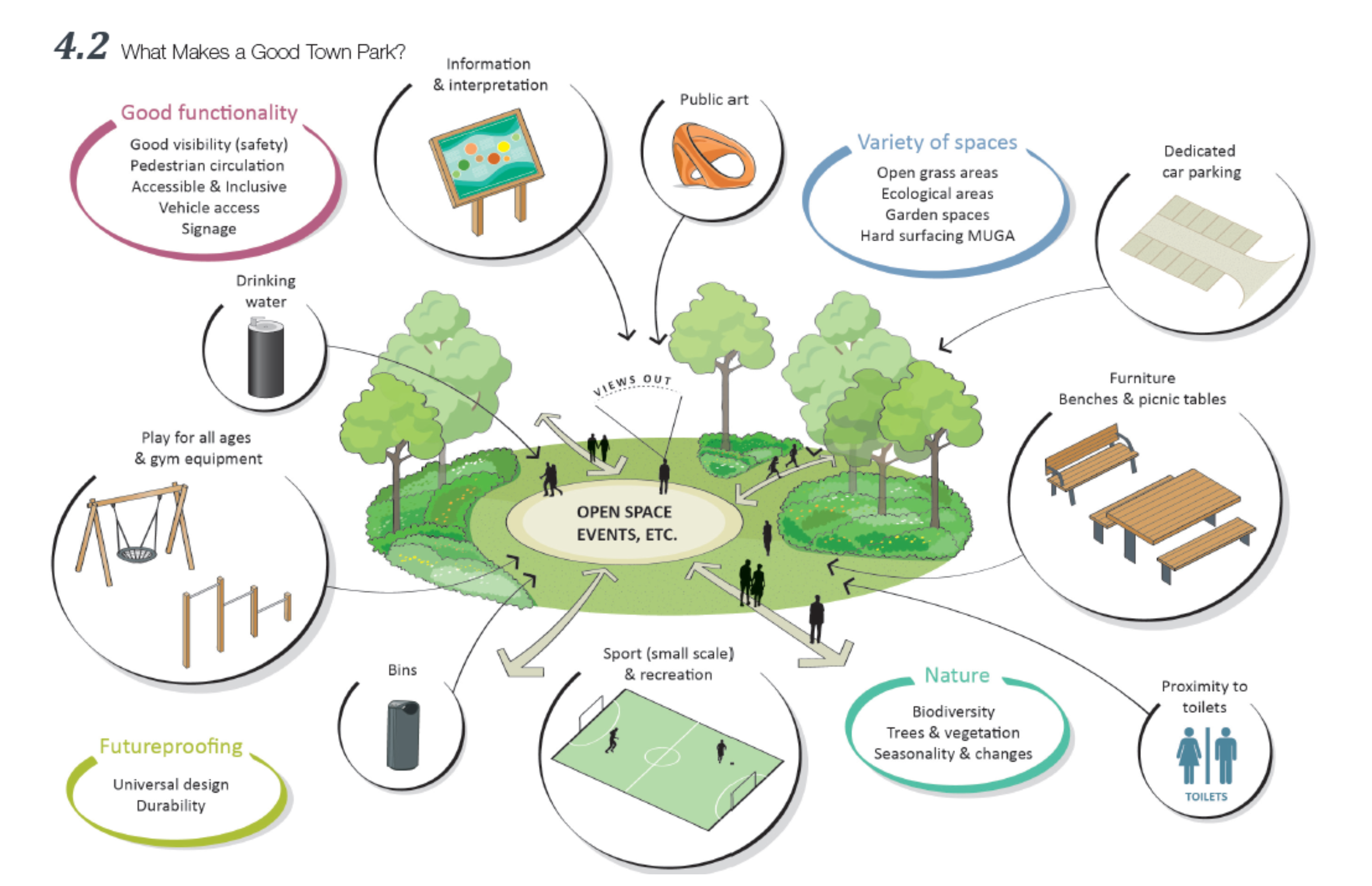
The provision of accessible and useable open space is a critical element in community building. Existing green infrastructure should be identified at the initial stages of the design process and should guide the design of an appropriate site layout. A landscaping plan submitted with an application should clearly illustrate how existing green infrastructure and opportunities to create more linkages have informed and been incorporated into the development layout.
Public open space within residential developments should be designed so as to complement the residential layout and be informally supervised by residents. A variety of types and sizes of open spaces should be provided at suitable locations to cater for the active and passive recreational needs of children and adults of all ages.
Policy
It is the policy of the Council:
Objectives
It is an objective of the Council:
|
Proposed Use |
Minimum Standard per 1000 population |
|---|---|
|
Children’s play area |
0.4 ha |
|
Urban Parks/General Amenity Space |
1.2 ha |
|
Playing Fields |
1.6 ha |
|
Overall requirements |
3.2 ha |
All houses should have an appropriate and useable area of private open space, exclusive of car parking, to the rear of the front building line. The minimum area of private open space to be provided is set out in Table 11.2. Exceptions to this may only be considered in relation to the redevelopment of brownfield/regeneration sites where a focus should be on design led and performance based outcomes rather than specific absolute requirements in all cases.
Flexibility will only be permissible in response to well–designed development proposals.
Housing developments which provide private open space at the minimum standard throughout the scheme will be discouraged.
Policy
It is the policy of the Council:
Residential development shall provide private open space in accordance with the requirements set out in Table 11.2. Each residential development proposal shall be accompanied by a statement setting out how the scheme complies with the requirements set out in Table 11.2.
|
House Type |
Minimum Area of Private Open Space to be Provided |
|---|---|
|
One/two bedroom |
55sq.m. |
|
Three Bedroom |
60sq.m. |
|
Four bedrooms or more |
75sq.m. |
Policies
It is the policy of the Council:
To require the provision of high quality, durable, appropriately designed, secure boundary treatments in all developments.
To consider the retention of field boundaries where such boundaries are of ecological/habitat significance, as demonstrated by a suitably qualified professional.
Objectives
It is the objective of the Council:
To require that boundaries between the rear of existing and proposed dwellings shall be a minimum of 1.8 metres high and shall be constructed as capped, rendered concrete block or brick walls, to ensure privacy, security and permanency. Alternative solutions will not be considered.
To require that all rear boundaries within the development shall be a minimum of 1.8 metres high and shall be constructed as capped, rendered concrete block or brick walls, to ensure privacy, security and permanency. Alternative solutions will not be considered.
Open plan front gardens will generally be discouraged and will only be acceptable in innovative layouts and where a high level of safety is achieved and services can be accommodated at a location which meets the needs of service providers. Open plan gardens will not be permitted on main access roads.
In general, where provided, front boundaries shall be defined by walls or fences at least 0.5 metres high in keeping with the house design and to a uniform scheme design.
In the case of residential development where the layout does not provide for front boundaries, there will be a general prohibition against the erection of front boundaries.
To require the provision of concrete post and concrete panel fencing at a minimum as a side boundary between dwellings.
All planning applications for residential development shall be accompanied by a schedule which demonstrates compliance with these requirements.
Policy
It is the policy of the Council
Objectives
It is an objective of the Council:
In all cases the name chosen for a residential development shall reflect local place names, particularly townlands or local names which reflect the landscape or shall reflect culture and /or history, including names of historical persons who have some association with the area.
Names shall be in English accompanied by an Irish translation. Name plates shall be fixed to walls and buildings where they can be clearly seen. Bilingual (Irish & English) street name plates, shall be erected on all estate roads at a location that is clearly visible.
In order to assist the public and delivery personnel, all houses within housing estates or in street developments shall be provided with numbers and/or names, which shall be visible from the adjoining roadway.
Applicants shall, as part of pre-application discussions include three draft name proposals in accordance with DM OBJ 50 and 51 for consideration.
Three draft name proposals in accordance with above objectives shall be submitted to the Planning Authority as part of a planning application. The name shall be approved by the Meath County Council Naming Committee.11
Objective
It is an objective of the Council:
All proposals for residential developments above 75 units shall incorporate works of public art into the overall scheme or make a financial contribution to the Council to provide the piece of public art in order to enhance the amenities of local environment (Refer to Chapter 7, Community Building).
Policy
It is the policy of the Council:
New residential development should be designed to maximise the use of natural daylight and sunlight. Innovative building design and layout that demonstrates a high level of energy conservation, energy efficiency and use of renewable energy sources will be encouraged.
Objectives
It is an objective of the Council:
Daylight and sunlight levels should, generally, be in accordance with the recommendations of Site Layout Planning for Daylight and Sunlight: A Guide to Good Practice (B.R.209, 2011), and any updates thereof.
Where taller buildings are proposed adjoining/adjacent to lower buildings, the Council may require that the developer submit daylight and shadow projection ; diagrams by a suitably qualified person(s) to appropriately demonstrate that the adjoining/adjacent properties will not be unduly affected by the proposed development.
Excessive transmission of sound between adjoining residential units can cause a nuisance to occupiers.
Objective
It is an objective of the Council:
To require that sound transmission levels in semi-detached, terraced, apartments and duplex units comply as a minimum with the 2014 Building Regulations Technical Guidance Document Part E or any updated standards, where appropriate a qualified sound engineer shall confirm that these levels have been met.
Please note this section must be considered in conjunction with Sections 4, 9 and 14 of this chapter.
Policies
It is the policy of the Council:
Apartment schemes shall generally be encouraged in appropriate, sustainable, locations, accessible to public transport in the following settlements: Drogheda, Navan, Dunboyne, Kilcock, Maynooth, Ashbourne and Dunshaughlin.
In towns and villages, there will be a general presumption against apartment developments however there are opportunities for infill developments and consolidation which would contribute to the regeneration of these settlements.
All planning applications for apartments are required to demonstrate compliance with ‘Sustainable Urban Housing; Design Standards for New Apartments’, Guidelines for Planning Authorities (2018) and any updates thereof. While these guidelines set out minimum design standards, the Council strongly encourage the provision of ; apartments above these standards, in the interest of creating attractive living environments and sustainable communities.
Objectives
It is an objective of the Council:
An appropriate mix of units shall be provided to cater for a variety of household types and tenures. Apartment development proposals will be assessed having regard to the following requirements:
All planning applications for apartment development shall be accompanied by a statement which sets out how the scheme complies with this objective.
A design statement is required to be submitted with any planning application for apartment development. The following minimum standards for floor areas, private open space provision and storage area requirements for apartments shall be complied with as set out in Table 11.3.
|
Apartment Unit Type |
Floor area |
Storage |
Private Open Space |
|---|---|---|---|
|
Studio |
37 m² |
3 m² |
4 m² |
|
One Bedroom |
45 m² |
3 m² |
5 m² |
|
Two Bedroom (3 person) |
63 m² |
5 m² |
6 m² |
|
Two Bedroom (4 person) |
73 m² |
6 m² |
7 m² |
|
Three Bedroom |
90 m² |
9 m² |
9m² |
Objectives
It is an objective of the Council:
Apartment development proposals shall also have regard to the following:
The build to rent (BTR) and shared accommodation sectors are emerging sectors in housing provision. Specific Planning Policy Requirement 7 and 8 of the Sustainable Urban Housing: Design Standards for New Apartments sets out the requirements in respect of BTR schemes including specific reference in public notices that a BTR scheme is proposed, supporting communal and recreational amenities must be provided and details of same must accompany any planning application.
The requirements in respect of shared accommodation or shared living/co-living are set out in Specific Planning Policy Requirement 9 of the Sustainable Urban Housing: Design Standards for New Apartments.
Objective
It is an objective of the Council:
To require that all planning applications for Build to Rent Schemes demonstrate compliance with Specific Planning Policy Requirement 7 and 8 of the Sustainable Urban Housing: Design Standards for New Apartments 2018 or any updates thereof.
To require that all planning applications for shared accommodation schemes demonstrate compliance with Specific Planning Policy Requirement 9 of the Sustainable Urban Housing: Design Standards for New Apartments 2018 or any updates thereof.
Infill development relates to development located in gaps between existing buildings in built-up urban areas. The Council will support infill development on appropriate sites that make the most sustainable use of serviced land and existing urban infrastructure.
Objectives
It is an objective of the Council:
Proposals for infill development shall accord with the following:
Infill development shall take account of the character of the area and where possible retain existing features such as building line, height, railings, trees,gateways etc.
Backland residential development relates to small scale development located to the rear of existing buildings in built-up areas.
Objectives
It is an objective of the Council:
Having regard to the requirement to protect the residential amenity and character of existing A1 residential areas backland site development shall satisfy the criteria for infill development, avoid undue overlooking and overshadowing of adjacent properties and shall respect existing building lines where possible.
Backland development proposals shall avoid piecemeal development that adversely impacts on the character of the area and the established pattern of development.
In the case of backland development proposals in urban areas the existing dwelling and the proposed dwelling shall have minimum individual private open spaces of 48sq.m for one or two bedroom units and 60sq.m plus for three/four+ bedroom units.
Corner Site/Side Garden development refers to sub-division of an existing house curtilage to provide an additional dwelling in existing built-up areas.
Larger corner sites may allow for a variation in dwelling design, however, proposals should more closely relate to adjacent dwellings, albeit with a modern design in order to avoid a pastiche development. At the discretion of the Planning Authority there may be some relaxation in private open space and car parking standards for this type of proposal.
Objective
It is an objective of the Council:
To require corner site /side garden development proposals to have regard to the following criteria: Size, design, layout, building line and the relationship with existing dwellings and immediately adjacent properties; External finishes; Accommodation standards for the occupants; Car parking for existing and proposed development; Private open space for existing and proposed development; Development Plan standards for dwellings; Side/gable and rear access/maintenance space, where possible.
One of the guiding principles of the RSES 2019-2031 is to, ‘Set out measures to reduce vacancy and the underuse of existing building stock and support initiatives that promote the reuse, refurbishment and retrofitting of existing buildings within urban centres’. It is desirable to maintain an element of residential use in or close to town centres as it provides night time activity. Further, a more substantial residential presence adds to the vitality and viability of a town centre. Unfortunately, residential uses in some of our towns and villages have become limited. As such, proposals for the residential conversion of the upper floors of retail and commercial premises will be favourably considered. Any proposed residential use must respect the historic fabric (if relevant), whilst also providing adequate residential amenity.
In recognising the need to protect the historic fabric of our towns/villages while encouraging people to live in upper floors of retail/commercial premises, it is not always possible or practical to achieve current residential standards. In this regard, at the discretion of the Planning Authority and subject to protecting residential amenity, a reduction in open space and car parking standards may be considered for ‘living over the shop’ accommodation proposals particularly in town centre locations. Minimum standards in relation to overall floor areas, storage space and natural light must be complied with in order to protect residential amenity.
The Department of Environment has brought in exemptions in relation to vacant commercial buildings being converted to residential use (applies until 31st December 2021). In this regard, a manual was launched by the Minister of State for Housing and Urban Development in 2019 entitled, ‘Bringing Back Homes’, to assist property owners, the public, local authorities and the construction industry to develop vacant buildings. Further information can be found at www.housing.gov.ie
Objectives
It is an objective of the Council:
To require that these proposals accord with the relevant guidelines and standards contained in this Plan and should contribute positively to the renewal of these areas and to the established character and amenities of the area.
To require that a separate and distinctive point of entry with an identifiable address be provided. Mitigation measures to address possible sources of external noise should be provided.
To encourage residential uses in existing under-utilised or vacant building stock as a mechanism to combat vacancy in town centres.
To require a high level of residential amenity ensuring natural light in living rooms and bedrooms and minimum standards are met in relation to overall floor areas and storage space requirements as set down in the Sustainable Urban Housing: Design Standards for New Apartments (DoHPLG, 2018).
To allow a reduction in open space and car parking standards for ‘living over the shop’ accommodation proposals in town centre locations, subject to protecting residential amenity, where considered appropriate by the Planning Authority.
At the discretion of the Planning Authority and subject to protecting residential amenity, a reduction in open space and car parking standards may be considered for ‘living over the shop’ accommodation proposals particularly in town centre locations.
The demand for high quality student accommodation is increasing nationally.
To promote the sustainable development of bespoke student accommodation at suitable locations in Maynooth Environs, Dunboyne and Drogheda.
Objectives
It is an objective of the Council:
To require that all proposals for student accommodation comply with the Department of Education and Science Guidelines on Residential Development for Third Level Students (1999), the subsequent supplementary document (2005) and the ‘Student Accommodation Scheme’, Office of Revenue Commissioner (2007), or any updates thereof.
To require that proposals for off-campus accommodation have regard to their proximity to existing or planned public transport corridors, cycle and pedestrian routes.
To require that written confirmation of a ‘Qualifying Lease’ as defined in the Guidelines on Residential Developments for Third Level Students published by the Department of Education and Science in 199912 which demonstrates that the accommodation is let to students within the academic year.
Objective
It is an objective of the Council:
Where an application is made for changes to the design or layout of elements of a ; residential scheme, the duration of the permission shall be linked by condition with that of the grounding permission. This is to ensure compliance with the Core Strategy and implementation of residential schemes in an orderly and integrated fashion.
Policy
It is the policy of the Council:
The creation of a custom-built ‘family flat13’ to be occupied by a member of the occupant family with a housing need is generally acceptable subject to site suitability and compliance with DM OBJ 80.
Objectives
It is an objective of the Council:
All applications for family flat development shall comply with the following criteria:
Objectives
It is an objective of the Council:
All applications for residential extensions in urban areas shall comply with the following criteria:
Home based economic activity is defined as small scale commercial activity carried out by residents of a house or person’s main residence, being subordinate to the use of the house as a single dwelling unit and includes working from home. The Council recognises that such working arrangements can benefit individuals, families and the local community in addition to contributing to more sustainable land use patterns by reducing the need for commuting. There is no objection to minor changes of use to allow for this provided the use remains ancillary to the main residential use, the applicant continues to reside in the house and the use has no adverse impact on the amenities of neighbouring dwellings.
Objectives
It is an objective of the Council:
In determining applications for developments involving working from home, the Council will have regard to the following:
Regard should be had to the number of individual bins required to serve each residential unit at design stage and in particular the requirement for segregating waste for recycling and food waste, (Refer to Chapter 6 Infrastructure for further details)
Policies
It is the policy of the Council:
All new residential schemes shall include appropriately sited and designed secure refuse storage areas, details of which shall be clearly shown in pre-application discussion and planning application documentation.
Objectives
It is an objective of the Council:
In residential schemes, appropriately sized bin storage areas must be provided to the front of terraced dwellings in locations which are easily accessible by the householder. These areas shall be well screened and the design shall integrate with the dwelling.
Apartment schemes shall make provision for waste segregation and recycling.
In apartment schemes, bin storage shall generally be on the ground floor level of development, be adequately ventilated, screened from public view and adjacent to the block it serves. Where appropriate, the bin storage area shall be a separate structure to the apartment building.
Shared bin storage areas shall be located conveniently for residents and collection ; service providers with appropriate security measures.
Development proposals should ensure that production/management methods do ; not give rise to environmental pollution, result in undue loss of amenity or be detrimental to public health.
All development proposals of five or more residential units shall include a Construction Environmental Management Plan (CEMP) with planning application documentation.
Construction Environmental Management Plans (CEMP) shall focus on waste minimisation and optimise waste prevention, re-use and recycling opportunities.
In the case of development which requires the removal of soil and stones, any removal requires the appropriate permits and disposal to authorised sites.
Legislation to regulate the short term letting sector, Planning and Development Act 2000 (Exempted Development) (No. 2) Regulations 2019 , came into effect on 1 July 2019 which is applicable only in areas designated as “rent pressure zones” (please refer to chapter 3 Settlement and Housing Strategy to obtain further information on rent pressure zones). These regulations are intended to address the ‘impact on the private rental market by the use of residential homes for short-term tourism type letting in areas of high housing demand’. Short-term letting is defined as ‘the use of a bedroom or bedrooms14 in a home as paid overnight guest accommodation for a continuous period of up to 14 days. Planning permission is now required to be obtained for a formal change of use.
Further details can be obtained from: https://www.housing.gov.ie/planning/private-rented-housing/new-regulation-short-term-letting
Retailing has an important role in the economy of the County. Retail development is generally located at key locations in our urban areas and has an important contribution to make to the character and sense of place of urban spaces. It is essential therefore that retail development is of a high design quality and at an appropriate scale to the centre in which it is located. (Please refer to Chapter 4 Economy and Appendix 4 Retail strategy for further information)
Policies
It is the policy of the Council:
To encourage the provision of new retail development in the County in accordance with the County Retail Strategy contained in Appendix 4, which will make a positive contribute to achieving the aims of the core strategy and the economic strategy.
To require that all retail development complies with the Retail Planning Guidelines for Planning Authorities in April 2012 and accompanying Retail Design Manual, or any updates thereof.
Objectives
It is an objective of the Council:
All retail proposals exceeding 1,000 sqm shall provide a detailed Retail Impact (RIA) and a Transport Impact Assessment (TIA) in addition to any other information deemed necessary by the Council.
To require the submission of a Construction Environmental Management Plan (CEMP) in respect of all retail proposals on sites exceeding 0.5 ha.
Fast food outlets have the potential to cause noise, littering and can detract from the amenities of an area. Therefore proposals for new or extended outlets will be carefully considered, particularly in locations where a proliferation of such uses already exists. Chapter 7 of the Development Plan sets out the Council’s policies and objectives in respect of its ‘Healthy Meath Strategy’. An over concentration of such uses will affect the achievement of the objectives of this strategy.
Policies
It is the policy of the Council:
To assess the appropriateness of any proposal for a new or extended takeaway/fast food outlet on the potential cumulative effect of these uses on the amenities of an area.
Give careful consideration to the appropriateness and location of fast food outlets in the vicinity of schools and, where considered appropriate, to restrict the opening of new fast food/takeaway outlets in close proximity to schools so as to protect the health and wellbeing of school-going children.
Objectives
To require that all proposals for new or extended fast food/takeaway outlets address the following as part of any pre- application discussion or planning application documentation:
To only consider drive-through restaurants in locations where development will not interfere with the free flow of traffic or detract from the amenities of an area.
Refer to Section 3 Public realm and section 11.8.1.2 Shop Fronts for further details.
Shop fronts make a significant contribution to the visual amenities of a settlement and many have strong heritage value which should be preserved.
The Council produced a ‘Shop front and Signage Guidance document in 2017 to assist designers of shop fronts and signage, which is available to download from www.meath.ie15 (Refer to Chapter 4 Economy and Employment Strategy).
Policy
It is the policy of the Council:
To ensure new/replacement shop fronts are of an appropriate scale and design in order to integrate successfully with existing streetscapes.
Objectives
It is an objective of the Council:
To require that proposals for new/replacement shop fronts have regard to the ‘Shop front and Signage Guidance’ document, 2017 or any updates thereof.
New/replacement shop front design shall respect the scale and proportions of the streetscape by maintaining the existing grain of development along the street and respecting the appropriate plot width.
Generally, individually mounted lettering or hand painted lettering is required. Letter design shall be simple and legible.
The choice of materials shall compliment the character of the building and integrate with the overall visual unity of the street scheme.
The use of roll-down or external type security screens will generally not be encouraged in town centre areas. Where the provision of screens is considered imperative, the use of perforated external and back lit screens or translucent internal screens will be considered.
Shops in neighbourhood centres in our larger settlements perform a key function locally providing services including convenience shopping, laundry, hairdresser, takeaways etc. The aim of providing such shopping facilities locally serve catchment areas within approximately 800 metres is to reduce the necessity to travel by car to the town centre to avail of basic services and thereby ensure reduced traffic congestion and improved sustainability.
Additional neighbourhood facilities may be required as part of large residential developments, these will be determined on a case by case basis have regard to the policies and objectives of Chapter 4 Economy and Employment and the Retail Strategy in Appendix 4.
In rural villages and nodes, these facilities often provide a focal point for the locality and can include post services etc
Policy
It is the policy of the Council:
To enable convenience retail needs to be better met locally and to encourage the provision of local convenience shops at an appropriate scale in residential areas in urban areas where there is a clear deficiency in retail provision, subject to the protection of residential amenity.
To encourage the provision of local convenience shops, exclusive of service stations, at an appropriate scale in rural villages and nodes where there is a clear deficiency in retail provision, subject to the protection of residential amenity.
Objective
It is an objective of the Council:
To ensure that the scale, design and proposed uses accord with the Council’s Retail Strategy.
The role of service stations has become more diverse with the expansion from merely selling fuel to also providing convenience services and goods including functioning as rest areas. Ancillary uses include tyre repair, collection points for online retail activity and self service launderettes.
Proposals for new and extended service stations will be carefully considered and will not generally be encouraged within the core retail area of urban centres or in rural areas outside of villages and rural nodes.
Policies
It is the policy of the Council:
Proposals for petrol filling stations in close proximity to the National Road Network shall have regard to the “Spatial Planning and National Roads Guidelines for Planning Authorities”, Department of Environment Community and Local Government, 2012 and the Dangerous Substances (Retail and Private Petroleum Stores) Regulations 1979 to 2010 (or any such other relevant standards and legislation that may be enacted).
Proposals for new and extended service stations will be carefully considered and will not generally be encouraged within the core retail area of urban centres or in rural areas outside of villages and rural nodes and shall be located in all cases within the speed limit restriction zones.
Service stations will not generally be permitted in/adjoining residential areas, unless ; it can be clearly demonstrated no significant effect on residential amenities by reason of as noise, traffic, visual obtrusion, safety considerations or fumes and smells. Hours of operation will be limited if a service station is permitted in a residential area. Proposals to demonstrate the above will be required to be submitted as part of pre-application discussion and planning application documentation.
Objectives
It is an objective of the Council:
The following shall be submitted as part of pre-application discussion and/or planning application documentation for a service station:
The retail strategy has outlined that there is no current need for additional floorspace of this type within the County. A very cautious approach will therefore be taken regarding further such development over the period of the Plan, (please refer to Chapter 4 Economy Strategy and Retail Strategy contained in Appendix 4 for further details), other then completion of existing parks and areas identified in Volume 2.
Any retail warehousing development shall be restricted to ‘bulky goods’ or goods which are not easily portable by customers travelling by foot, bicycle, or bus (See Annex 1 of Retail Planning Guidelines 2012 for definitions of bulky goods), otherwise these developments could have a damaging material impact on the commercial viability of town centres. Ancillary products should not exceed 20% of the total net retail floorspace of the relevant retail unit.
Objectives
It is an objective of the Council:
To ensure that retail warehousing is only permissible on lands identified in Volume 2 of this Development Plan for this use. All planning applications for retail warehousing shall set out clearly in the planning documentation how the proposal complies with the Retail Planning Guidelines 2012, this Development Plan and the Retail Strategy.
Building on the momentum of the successful implementation of the Economic Strategy and having regard to the need identified in the RSES to address the disconnect experienced most acutely in the Mid East between where people live and work the Council is setting out an ambitious programme for the delivery of a wider spread of economic growth throughout the County. Support structures are in place in the Council to encourage the development of quality enterprise development.
The Development Plan identifies a range of lands to accommodate various employment uses. It is intended that these areas will develop as high quality, sustainable working environments which will attract further investment. Therefore the Development Plan places significant emphasis on ensuring development proposals are of high design quality, suitably landscaped, provide good facilities for pedestrians and cyclists and include staff facilities. The choice of coloured cladding used should be most suitable to Ireland’s natural landscape. The development of high quality employment development is a critical component to releasing and supporting the ‘live work’ community concept.
This section should be considered in conjunction with Chapter 4 Economy and Employment. Section 9 sets out the applicable parking standards for these developments.
Objectives
It is an objective of the Council:
To require innovative contemporary designs for new industrial, office, ; warehousing and business park developments.
DM OBJ 106 That indicative site coverage for industrial/commercial development on greenfield sites is 50% coverage unless the design characteristics of the ; scheme, proposed uses and mobility management plan indicate support for higher site coverage.
In town centre locations, in order to encourage and facilitate the development of a compact town centre, and to achieve desirable massing and heights of buildings, plot ratio and site coverage of 1.5 and 70% respectively will generally be the norm.
To require that full details of the proposed use(s), including industrial processes involved provided as part of any planning application.
To require that full details of the hours of operation be provided as part of any planning application.
To require that details of suitable access arrangements, internal roads layout including details of footpaths, turning areas, loading bays be provided as part of any planning application.
Boundaries which are visible from the public road should be of a high architectural quality. Palisade fencing to the front of any building line shall not be permitted.
The use of retention ponds as an urban design feature within business parks will be encouraged to enhance the setting, subject to compliance with all relevant safety requirements.
To require that proposals for and location of on site areas for storage and disposal (if applicable) of waste be provided as part of any planning application. All external storage including bin storage, oil tanks, etc, shall be visually screened from public areas, details to be provided as part of any planning application.
To require that waste and recycling areas be covered, screened and enclosed from public view and wind, compliant with the Council’s Waste Management Strategy.
All overground oil, chemical storage tanks should be adequately bunded to protect against spillage.
Existing trees and hedgerows of biodiversity and/or amenity value shall be retained, where possible.
To require that a survey of any existing vegetation on site and a suitable landscaping scheme prepared by an appropriately qualified professional, taking account of same, be submitted as part of any planning application to enhance the development.
Open space shall be provided in suitable locations as part of the development in order to enhance the development and provide amenity and passive recreation for future employees.
To require that all significant Industrial, Office, Warehousing and Business Park Development incorporate works of public art in the form of outdoor sculptures, special architectural and landscape features or other appropriate art work in the development.
To require that all planning applications for Industrial, Office, Warehousing and Business Park Development on sites in excess of 0.5 hectares are accompanied by a Construction Environmental Management Plan (CEMP).
To require that all new developments with over 100 employees shall have a Mobility Management Plan.
To encourage the provision of supporting facilities for employees including ; childcare facilities, leisure uses and coffee shops in business parks.
To encourage research and development activities as an ancillary part of all new and existing business parks in the County in conjunction with 3rd level Institutions.
The design, scale, siting and layout of agricultural buildings should respect, and where possible, enhance the rural environment, (Refer to Chapter 9 Rural Development for further information.)
Objectives
It is an objective of the Council:
To require that buildings are sited appropriately in order to minimise obtrusion on the landscape, having regard to the Landscape Character Assessment contained in Appendix 5.
The use of dark coloured cladding, for example dark browns, greys, greens and reds are most suitable for farm buildings, and roof areas should be darker than walls.
Developments shall comply with the European Union (Good Agricultural Practice for Protection of Waters) (Amendment) Regulations 2014, (GAP Regs 2014).
All planning applications for agricultural development shall be accompanied by ; comprehensive details of all land holdings and herd number(s), if applicable.
All new and existing agricultural developments will be required to contain sufficient detail which demonstrates that all effluent, including yard run-off, is collected and stored within the confines of the development.
In the case of new farm enterprises, a clear evidence base must be provided which demonstrates the need for the proposal and details of how any buildings proposed form part of a comprehensive business plan for the farm holding supported by Teagasc.
The Council recognises the contribution of the extractive industry in supporting jobs in the construction and aggregates section of the County. (Please refer to Chapter 9 Rural Development Strategy for grounding policies and objectives regarding extractive industries).
Policies
It is the policy of the Council:
To require that all extract industry development complies with the requirements of Section 261 and Section 261A of the Planning and Development Act, 2000 (as amended), the Quarries and Ancillary Activities Guidelines 2004 or any updates thereof and EPA Guidelines for Environmental Management in the Extractive Industry 2006 or any updates thereof.
To encourage the rehabilitation of disused pits and quarries to productive agricultural use where appropriate having regard to all appropriate environmental considerations.
Objectives
It is an objective of the Council:
All applications for extract industry development shall comprehensively address the following criteria as part of a pre-application discussion and/or planning application proposal:
Where possible, sites shall be subject to rehabilitation and landscaping programmes in tandem with the various phases of extraction. Possible uses post closure could include local recreational facilities and habitat areas, where appropriate community support exists and subject to funding.
The Council recognises the need for land reclamation for the improvement of agricultural lands. It is also of note that in recent years significant pressure has come on the Council to facilitate the provision of waste recovery sites for soil and stone.
Policy
It is the policy of the Council:
To require that all land reclamation developments which include the importation of any material onto site have the requisite waste authorisation is in place in accordance with the stipulations of the Waste Management Act 1996.
Objectives
It is an objective of the Council:
All applications for land reclamation / soil and stone recovery shall comprehensively address the following criteria as part of a pre-application discussion and/or planning application proposal:
The Council recognises that the provision of care for the elderly and other vulnerable people in our community is an essential requirement particularly in the context of changing national demographics. A range of accommodation options fall within this sector including: step down housing which supports independent living as support services are available in a complex arrangement, nursing homes , retirement homes etc (Please refer to Chapter 7 Community Building for further details).
Nursing homes, residential and retirement homes and retirement villages should be located in towns and villages for reasons of sustainability, accessibility and proximity to services.
There is a presumption against this type of development in the open countryside for reasons relating to sustainability, poor accessibility and lack of public transport, social exclusion and isolation.
Policy
It is the policy of the Council:
Require that residential care homes, retirement homes, nursing homes, retirement villages and sheltered accommodation/step down housing be located in towns and villages for reasons of sustainability, accessibility, social inclusion, and proximity to the availability of services, except where a demonstrated need to locate in a rural environment because of the nature of the care required can be clearly established.
Objectives
It is an objective of the Council:
Planning applications for the change of use of a residential dwelling or other building to nursing home, residential care home, or for the construction of new residential care homes, retirement homes, nursing homes, retirement villages or sheltered accommodation/step down housing, shall be assessed for compliance with the following criteria:
Reduced open space standards may be acceptable for the following development types: residential care homes, retirement homes, nursing homes, retirement villages and sheltered accommodation only in cases where it is clearly demonstrated with a supporting evidence base that it is appropriate by having regard to the specific open space needs of residents and only where suitable accessible public open space is available as part of the development.
There is a continuing demand for suitable high quality childcare facilities in the County, (Refer to Chapter 7 Community Building for the grounding policies in respect of childcare development).
Applicants are encouraged to seek the advice and support of the County’s Childcare Committee, Tulsa, HSE and other relevant bodies in the design and layout of proposed childcare facilities prior to the submission of a planning application.
Policy
It is the policy of the Council:
To facilitate the provision of childcare facilities in appropriate locations as set out in DM POL 35 in accordance with the provisions of the DoEHLG ‘Childcare Facilities Guidelines for Planning Authorities’ (2001).
Development of childcare facilities at the following locations will normally be encouraged:
Objectives
It is an objective of the Council:
Planning applications for childcare facilities shall be assessed for compliance with the following criteria:
All applications for childcare facilities shall comprehensively set out the following as part of a pre-application discussion and/or planning application proposal:
In the case of proposals within an existing dwelling the Council will consider whether there is sufficient private open space remaining for the enjoyment of the occupant of the dwelling. The potential impact on the residential amenities of adjoining residences will also be considered. In such cases a significant residential component shall be retained.
The Council will be guided by the Department of Education and Skills as to the need for new educational facilities or expansion of facilities at existing schools (Please refer to Chapter 7 Community Building for grounding policies in respect of educational facilities).
Policies
It is the policy of the Council
All sites for schools shall comply with the requirements of the following:
Objectives
It is an objective of the Council:
Assessing planning applications for new schools and/or redevelopment/extensions ; of existing schools, the Planning Authority will have regard to the following:
Temporary classrooms will be assessed on a case-by-case basis and will generally be accepted for a temporary period not exceeding five years and such classrooms should not interfere with onsite car/cycle parking spaces or unduly impact the usability of outdoor play/sports facilities. Any such proposal shall be accompanied by a timeline for the construction of permanent facilities.
Extensions to schools will generally be accepted subject to scale, high quality design and satisfactory integration with the existing structure. School extensions should not negatively impact on adjoining amenities and amenities within the school site.
Dual function of sports facilities/halls etc, outside of school hours will be encouraged where the use of such facilities will be of a benefit to the wider community, however, any outside hours usage of the school should not be to the detriment of adjoining residential amenities.
To require that all planning applications for new schools are accompanied by a Mobility Management Plan. Existing schools seeking permission to expand will also be required to provide a Mobility Management Plan.
The pattern of religious practice is becoming increasingly diverse in County Meath arising in part from the significant in migration into the County. This Development Plan supports proposals for the regular use of a building as a place of worship or religious instruction in the context of the land use zoning of the site and the amenities of the area.
Objectives
It is an objective of the Council:
To require that details in relation to the capacity of the facility (seating capacity), hours of operation and a traffic assessment (including details of the proposed parking provision) accompany any pre application discussion and/or planning application proposal.
To require that all planning applications for new places of worship are accompanied by a Mobility Management Plan.
Objective
It is an objective of the Council:
All proposals for allotment development of shall be assessed against the following criteria:
The Council encourages and facilitates early pre-application discussions on these projects.
Refer to Chapter, 6 Infrastructure which contains the grounding policies and objectives relevant to energy related development.
Refer to Section 11.4.4, Strategic Infrastructure Development as the proposal may fall within a category of development which constitutes SID.
Policy
It is the policy of the Council:
To encourage renewable development proposals which contribute positively to reducing energy consumption and carbon footprint.
Objectives
It is an objective of the Council:
In the assessment of individual energy development proposals, the Council will take the following criteria into account:
There are a variety of solar technologies available in the form of roof-top domestic, roof-top commercial, large-scale ground land (where solar cells are mounted to supply energy to the grid) and solar energy storage facilities. There are a significant number of solar farm planning applications in the system nationally. Section 28 Guidance is awaited from the Department of Housing and Planning to assist in the assessment of this development type.
Policy
It is the policy of the Council:
To implement Section 28 Guidelines from the Department of Housing, Planning and Local Government on Solar Farms when available.
Objectives
It is the objective of the Council:
To require that any pre-application discussion and/or planning application proposal for solar farm development sets out how the project complies with DM OBJ 146 above.
To ensure that proposals for the development of solar farms are not located within areas identified as being within Flood zones A or B as per the Planning System and Flood Risk Management Guidelines 2009 for Planning Authorities (or any updated guidelines)
Policy
It is the policy of the Council:
Objectives
It is the objective of the Council:
To require that any pre-application discussion and/or planning application proposal for wind farm development sets out how the project complies with DM OBJ 146.
Topographical enclosures and extensive areas of degraded or previously developed lands should be identified for wind farm development to help minimise visual impacts and to harmonise wind turbines with the landscape.
In general, matt finishes and neutral colours for turbines and structures are required.
The Council will support appropriate innovative designs for wind farms.
All planning applications shall be accompanied by detailed proposals for the restoration of the site after removal of the turbines and associated infrastructure including access roads. Adequate financial security will be required to ensure site restoration and removal of the wind farm.
Objectives
It is an objective of the Council:
In the assessment of individual proposals, the Council will take the following criteria into account:
High quality communications and information technology networks are critical for the continued implementation of the Economic Strategy. Please refer to Chapter 6 for grounding policies for telecommunications and broadband.
Policy
It is the policy of the Council:
To require compliance with the requirements of the “Telecommunications Antennae and Support Structures – Guidelines for Planning Authorities” July 1996, except where they conflict with Circular Letter PL 07/12 which shall take precedence, and any subsequent revisions or expanded guidelines in this area.
Objectives
It is an objective of the Council:
Encourage the location of telecommunications structures at appropriate locations within the County, subject to environmental considerations.
Require the co-location of antennae on existing support structures and where this is not feasible require documentary evidence as to the non-availability of this option in proposals for new structures.
To avoid the location of structures in sensitive landscapes, in nature ; conservation areas, in highly sensitive landscapes and where views are to be preserved. (Please refer to Chapter 8 Cultural Heritage, Natural Heritage, Landscape and Green Infrastructure and Appendices 6-9 inclusive for further details).
To generally discourage the use of wires or other devices affixed to the facade of buildings in town and village centres.
To encourage the development of open access networks in all developments.
Anaerobic Digesters are widely used in the agricultural sector in the form of small on‐farm digesters producing biogas to heat farmhouses and other farm buildings.
An Anaerobic Digestion plant typically comprises of:
Plants can vary in scale from small schemes treating the waste from an individual farm through medium‐sized centralised facilities dealing with wastes from several farms (potentially supplemented by crops such as maize grown specifically to feed the digester) to sizeable industrial AD plant handling large quantities of municipal solid waste. In the case of small plants it is likely that the plant can be accommodated within the vicinity of existing farm buildings. Some forms of biomass produce digestate and other end products which must be disposed of.
Siting is a key consideration when assessing proposals for Anaerobic Digesters. The development of a bio energy project regardless of scale has development implications on the environs in which it will be situated. The development impacts which may be exacerbated by an improperly sited bio energy project. Key considerations include:
Objective
It is the policy of the Council:
To seek to facilitate the development of alternative energy sources where such proposals are consistent with landscape preservation, the protection of natural habitats, the protection of visual and residential amenities and Development Plan policy and the principles of proper planning and sustainable development.
One of the cross cutting themes of the Development Plan is to encourage a shift to more sustainable forms of transport. The provision of sufficient car parking is important particularly in areas of the County which are currently poorly served by public transport networks. Therefore the rationale for the application of car parking standards is to ensure that consideration is given to the accommodation of vehicles in assessing development proposals while being mindful of the need to promote a shift towards more sustainable forms of transport.
Objective
It is the objective of the Council:
Car parking shall be provided in accordance with Table 11.4 and associated guidance notes.
|
Land Use – Residential |
Car Spaces |
|---|---|
|
Dwellings |
2 per conventional dwelling |
|
Flats/ Apartments18 |
2 per unit |
|
Hotel Accommodation (excluding bars, functions rooms, etc.) |
In all cases, 1 visitor space per 4 apartments |
|
B&B / Guesthouse |
1 per bedroom |
|
Hostel Accommodation |
1 per bedroom |
|
Self-Catering Accommodation |
1 per bedroom or 1 per 10 beds |
|
Caravan/Mobile Home Parks |
1 per unit |
|
Institutions |
1 per employee |
|
Student Accommodation |
To be determined on a case by case basis |
|
Land Use – Employment |
|
|
Manufacturing Industry |
1 per 50 sq.m. gross floor area |
|
Warehousing |
1 per 100 sq.m. gross floor area |
|
Offices |
1 per 25 sq.m. gross floor area. Where the floor area exceeds 1,500 sq.m. gross floor area, 1 space per 50sq.m. gross floor area. |
|
Data Centres |
1 per 100 sq.m. gross floor area |
|
Land Use – Commercial |
|
|
Food Retail |
1 per 20 sq.m. gross floor area. Where the floor area exceeds 1,000 sq.m. gross floor area, 1 space per 14 sq.m. gross floor area. *Provision should be made for taxi drop off spaces. |
|
Non Food Retail |
1 per 20 sq.m. gross floor area. |
|
Retail Warehousing |
1 per 20 sq.m. gross floor area |
|
Cash and Carry |
1 per 50 sq.m. gross floor area |
|
Banks |
1 per 20 sq.m. gross floor area |
|
Restaurants |
1 per 5 sq.m dining area |
|
Bars, Night Clubs, Lounges, Function Rooms incl. such spaces in hotels |
1 per 4 sq.m. of public area |
|
Vehicle Service Station |
4 per fuel pump provided |
|
Retail Outlets within Vehicle Service Garages |
1 per 10 sq. m of net floor area. 1 HGV parking space per 30sq.m. net floor area is required where food is served on the premises. |
|
Land Use - Health and Education Facilities |
|
|
Hospitals |
1 per bed |
|
Surgeries |
2 per consulting room |
|
Nursing Homes |
1 per 3 beds and one space per employee |
|
Schools |
3 per classroom plus dedicated pick up/set down area within site boundary |
|
Colleges/Third Level Institutions |
To be determined by the Planning Authority. |
|
Land Use - Community Facilities |
|
|
Places of Public Worship |
1 per 4 seats |
|
Libraries |
1 per 20 sq.m. gross floor area |
|
Cultural buildings |
To be determined by the Planning Authority |
|
Crèches |
1 per employee & dedicated set down area and 1 per 4 children plus dedicated set down area |
|
Cinemas/Theatre |
1 per 3 seats. Where gross floor area exceeds 1000 sq.m., 1 space per 5 seats. |
|
Funeral Homes |
1 per 5 sq. m. gross floor area |
|
Community Centres |
1 per 5 sq. m. gross floor area |
|
Allotments |
1 space per plot |
|
Land Use - Sports Facilities |
|
|
Sport Clubs-including swimming pools, tennis courts, gyms, fitness studios, etc. |
2 per court, 5 per 100 sq.m. |
|
Golf / Pitch & Putt courses |
3 per hole |
|
Golf Driving Ranges |
1 per 2m of base line/per trap whichever is less |
|
Bowling Alleys |
5 per lane |
|
Stadia |
To be determined by the Planning Authority |
|
Playing fields |
15 spaces per pitch |
Guidance Notes
Objective
It is an objective of the Council:
The dimension of parking bays shall comply with Table 11.5
|
Parking dimensions (Perpendicular to Kerb) |
5.0m x 2.5m |
|
Where space is adjacent to a wall or other obstruction |
5.0m x 2.75m |
|
Parking dimensions (Parallel to Kerb) |
6.0m x 2.5m |
|
Accessible Parking Bay to comply with Building Regulations. |
5.0m x 2.5m + 1.2m to the sides and rear of each space |
|
Loading Bay |
6.0m x 3.0m |
|
Circulation Aisles |
6.0m in width |
Objective
It is an objective of the Council:
Car parking provision shall normally be provided within the curtilage of the development site. Where, in the opinion of the Council, it would be impracticable for individual developers to provide for on-site parking, a contribution may be required.
Loading bays shall be located and designed to prevent any obstructions to traffic circulation and to accommodate vehicular manoeuvring on site.
New residential development should take account of the following regarding car parking:
The Climate Action Plan, 2019 acknowledges that the pricing structure for EV vehicles is a major factor in consumers decision making. However the Plan also acknowledges the importance of ‘ensuring the EV Charging network underpins public confidence.’19 The Council will encourage the provision of EV charging points in all developments for future proofing.
Objective
It is an objective of the Council:
All car parks shall include the provision of necessary wiring and ducting to be ; capable of accommodating future Electric Vehicle charging points, at a rate of 10% of total space numbers.
In any car park in excess of 20 spaces where public access is available, one fully functional charging point for Electric Vehicles shall be provided in accordance with IEC 61851 Standard for Electric Vehicle Conductive Charging Systems.
The Council will require an appropriate amount of cycle parking facilities to be provided with new development.
Objectives
It is an objective of the Council:
To require the provision of cycle parking facilities in accordance with Table 11.6 Cycle Parking Standards.
Cycle parking facilities shall be conveniently located, secure, easy to use, adequately lit and well sign posted. All long-term (more than three hours) cycle racks shall be protected from the weather.
Secure cycle parking facilities shall be provided in new office, residential apartment ; development, retail and employment generating developments. Such facilities shall be within 25 metres for short-term parking, (shops) and 50 metres for long term parking (school, college, and office). The number of stands required will be a third of the number of car spaces required for the development, subject to a minimum of one stand.
In residential developments without private gardens or wholly dependent on balconies for private open space, covered secure bicycle stands should be provided in private communal areas;
All cycle facilities in multi-storey car parks shall be at ground floor level and segregated from vehicle traffic. Cyclists shall also have designated entry and exit routes at car parks.
|
Type of Development |
Cycle Parking Standard |
|---|---|
|
Residential units |
1 private secure bicycle space per bed space (note – design should not require bicycle access via living area), minimum 2 spaces |
|
Apartments |
1 visitor bicycle space per two housing units |
|
Shops |
1 space for every 10 car spaces or 1 space per till/checkout, whichever is greater |
|
Offices |
10% of employee numbers subject to minimum of 10 bicycle places or one bike space for every car space, whichever is the greatest. |
|
Schools20 |
25% of pupil registration numbers/minimum of 10 spaces. Consider separate teacher/employee parking. |
|
Other developments |
1 bike space per car space, or 10% of employee numbers in general |
|
Off Street car parks (including Multi-Storey Car Parks) |
10% of total car spaces/minimum provision of 50 spaces |
|
On-street (public) |
Minimum of 5-10 spaces, depending on expected level of usage |
|
Public Transport pick up points/interchanges |
2.5% of number of daily boarders at that point/station, minimum of 10 bicycle spaces |
|
Events |
5% of forecast attendees |
Accessible taxi services are important in providing a demand responsive 24 hour door-to-door service.
Objective
It is an objective of the Council:
Planning applications for significant commercial, industrial and other developments taxi services shall demonstrate the provision of adequate drop-off and set-down ; areas for taxi services.
To require the provision of facilities for taxis in all new supermarket and neighbourhood development proposals.
Advertising structures are an accepted and necessary part of commercial activity and are essential for way finding.
Policy
It is the policy of the Council:
To permit only advertisements which enhance the appearance and vitality of an area and make a positive contribution to the streetscape.
Objectives
It is an objective of the Council:
The following signage types will be discouraged:
In assessing advertising signage, the Council will consider the following criteria:
Advertisement structures will not be permitted where they give rise to a potential traffic hazard. In general, advertisement structures will not be permitted at roundabouts, at traffic signalised junctions, at locations where they obstruct sight lines, compete with other traffic signs, give rise to confusion for road users or p; endanger traffic safety.
Applications for advertisement structures along national routes and along approach roads to towns and villages will generally not be permitted except for tourist attractions of national or regional importance which utilise the approved designated signage.
The number of advertisement structures for any one premises shall be kept to a minimum and will generally be restricted to a maximum of two in the local area. In exceptional cases this maximum may be exceeded at the discretion of the Council.
The use of electronic variable messaging signs commonly known as “VMS signs”, shall be reserved strictly for use in roadwork activities, hazard information and or as part of an approved event traffic management plan. Advanced written consent of the Council will be required prior to installation and usage of such signage.
In urban centres where public realm strategies have been prepared the Council reserve the right to de-exempt any signage in the interests of visual amenity in these areas.
Advertising hoardings, including tri-vision and three-dimensional signs, if inappropriately located can constitute one of the most obtrusive elements of all forms of outdoor advertisement. They rely for their impact on size, scale and location and are thus usually detrimental to the character of the area in which they are situated and in some cases contribute to a traffic hazard. However, they can help to screen derelict or obsolete sites awaiting re-development, in certain circumstances.
The practice of parking trailers or other mobile objects bearing advertisements in fields adjoining roads has become a feature of Irish roads over the past number of years. Such advertisements can be harmful to the visual amenities of the area, represent a traffic hazard by virtue of distracting motorists and could have impacts on biodiversity. Where such advertisements do not have the benefit of planning permission, the Council shall take appropriate enforcement action. The potential negative impacts of such development shall also be taken into account in assessing applications for such development.
Objective
It is an objective of the Council:
Outdoor advertising hoardings shall not be permitted where it would detract from applications for such development will be considered on the basis of the visual impact of the proposed advertising hoarding and the potential for a traffic hazard arising from same will be imperative. The number and scale of hoardings in the vicinity of the site will be a material consideration.
Section 48 of the Planning and Development Act 2000 (as amended) allows the Planning Authority when granting planning permission to include conditions requiring the payment of a financial contribution in respect of public infrastructure and facilities benefitting development in the area of the planning authority and that is provided, or that it is intended will be provided, by or on behalf of a local authority. The current Meath County Development Contributions Scheme 2016 – 2021 (as amended)21 sets out the contributions applicable to development, the scheme should be consulted in advance of the making of a planning application. There are three type of development contributions; General, Special and Supplementary.
These contributions apply in respect of public infrastructure and facilities provided by or on behalf of the Planning Authority that benefit development in its functional area, as noted above. Section 48 (1) of the Act outlines that a Planning Authority when making a grant of permission, may include a condition requiring the payment of a contribution in respect of public infrastructure and facilities such as open spaces, community and recreational facilities and amenities and landscaping works; infrastructure to facilitate public transport, cycle and pedestrian facilities; refurbishment, upgrading, enlargement or replacement of roads and surface water drainage infrastructure.
In circumstances where additional specific infrastructure for an area is required, the Council may attach a special contribution. Developers may also be required to carry out works at their own expense to facilitate their development and this would be specified as a condition of the planning permission.
Under Section 49 of the Act, a Planning Authority may, when granting permission include conditions requiring the payment of a contribution in respect of any public infrastructure service or project specified in a “Supplementary Development Contribution Scheme” that will benefit the development to which the planning permission relates.
The Council has adopted Supplementary Development Contribution Schemes for the following projects:
These schemes remain active. The Council will consider the need for additional contribution schemes over the plan period.
Developments shall be restricted (and where appropriate, prohibited) in public safety zones and approach zones of airports and airfields, and in noise zones associated with airport flight operations as illustrated on Map 5.4.1 & 5.4.2. In the assessment of such applications regard shall be had to the relevant policy documents and consultation shall take place with the relevant authorities. Please refer to Chapter 5 Movement.
Policies
It is the policy of the Council:
To strictly control inappropriate development and require noise insulation where appropriate within the Outer Noise Zone.
To actively resist new provision for residential development and other noise sensitive uses within the Inner Noise Zone, as shown on Map no. 5.4.1 and 5.4.2.
Under no circumstances shall any dwelling be permitted within the predicted 69 dB LAeq 16 hours noise contour. Residential development in areas likely to be affected by levels of noise inappropriate to residential use should be avoided.
Comprehensive noise insulation shall be installed for any house permitted. Any planning application shall be accompanied by a noise impact assessment report produced by a specialist in noise assessment which shall specify all proposed noise mitigation measures together with a declaration of acceptance from the applicant with regard to the recommendations of the noise impact assessment report.
Objective
It is an objective of the Council:
Development should be restricted which would give rise to conflicts with aircraft movements on environmental or safety grounds on lands in the vicinity of Dublin Airport and on the main flight paths serving Dublin Airport.
The Seveso III Directive, 2012/18/EU came into force in Ireland on 1st June 2015 replacing the Seveso II Directive, 96/82/EC. The Seveso III (Directive 2012/18/EU) was adopted taking into account, amongst other factors, the changes in EU legislation on the classification of chemicals and the increased rights for the public to access information and justice.
This Directive is aimed at the prevention of major accidents involving dangerous substances. However, as accidents may nevertheless occur, it also aims at limiting the consequences of such accidents not only for human health but also for the environment.
The Directive covers establishments where dangerous substances may be present (e.g. during processing or storage) in quantities above a certain threshold. Excluded from the Directive are certain industrial activities which are subject to other legislation providing a similar level of protection (e.g. nuclear establishments or the transport of dangerous substances).
Depending on the amount of dangerous substances present, establishments are categorised in lower and upper tier establishments, the latter are subject to more stringent requirements.
The Chemicals Act (Control of Major Accident Hazards involving Dangerous Substances) Regulations 2015 (S.I. No. 209 of 2015) (the “COMAH Regulations”), implement the Seveso III Directive (2012/18/EU). The purpose of the COMAH Regulations is to lay down rules for the prevention of major accidents involving dangerous substances, and to seek to limit as far as possible the consequences for human health and the environment of such accidents, with the overall objective of providing a high level of protection in a consistent and effective manner.
The intention is to achieve this through tiered controls on the operators of the establishments subject to the Regulations - the larger the quantities of dangerous substances present at an establishment, the more onerous the duties on the operator.
The European Communities (Control of Major Accident Hazards Involving Dangerous Substances) Regulations 2006 and the European Union (Control of Major Accident Hazards Involving Dangerous Substances) (Amendment) Regulations 2013, which implemented the Seveso II Directive (96/82/EC), have been revoked by the European Union (Control of Major Accident Hazards Involving Dangerous Substances)(Revocation) Regulations 2015 (S.I. No. 208 of 2015) and replaced by the COMAH Regulations.
Part 7 of the COMAH regulations 2015 provides that appropriate consultation procedures must be put in place to ensure that before decisions are taken, technical advice is available to Planning Authorities in respect of:
Such technical advice will be taken into account in the consideration of applications for planning permission.
The Central Competent Authority in the case of planning advice is the Health and Safety Authority (“HAS”). The HSA are also obliged to provide the Planning Authority with information to assist in the long term planning of the County in order to:
|
Map 11.1 |
Name of Company |
Seveso Location |
Seveso Tier |
Consultation Radius Distance from Facility |
County |
|---|---|---|---|---|---|
|
Site 1 |
Boliden Tara Mines DAC |
Knockumber Road, Navan, Co. Meath |
Upper Tier |
1,000 metres |
Meath |
|
Site 2 |
Xtratherm Limited |
Liscarton Industrial Estate, Kells Road, Navan |
Lower Tier Site |
1000 metres |
Meath |
|
Site 3 |
Grassland Fertilizers Limited |
The Pound Road, Slane |
Lower Tier Site |
700 metres |
Meath |
|
Site 4 |
Flogas Ire. Ltd |
Marsh Road, Drogheda |
Upper Tier Site |
600 metres |
Louth |
|
Site 5 |
Irish Industrial Explosives Limited |
Clonagh, Enfield |
Upper Tier Site |
1000 metres |
Kildare |
|
Site 6 |
Clarochem Ireland Ltd |
Damastown, Mullhuddart, |
Lower Tier Site |
1000 metres |
Fingal |
|
Site 7 |
Chemco (Ireland) Limited (t/a Chemsource Logistics) |
Macetown North, Damastown Industrial Estate, Mullhuddart |
Upper Tier Site |
1,000 metres |
Fingal |
|
Site 8 |
Aestellas Ireland Co. Ltd |
Damastown Industrial Park, Mullhuddart |
Lower Tier Site |
1,000 metres |
Fingal |
|
Site 9 |
Guerbet Ireland ULC |
Damastown Industrial Estate, Mullhuddart |
Upper Tier Site |
1,000 metres |
Fingal |
At present there are 3 no. Seveso III sites in the County. In addition, there are 5 no. Seveso III sites in neighbouring counties Louth, Fingal and Kildare where the ‘Seveso Consultation Distance’ extends into the County or whose consultation distance overlaps with the consultation distance of adjoining sites which extend into the County.
Policies
It is the policy of the Council:
To comply with the Seveso III Directive in reducing the risk and limiting the potential consequences of major industrial accidents.
To permit new Seveso development only in low risk locations within acceptable distances from vulnerable residential, retail and commercial development.
To ensure that land use policies take account of the need to maintain appropriate distances between future major accident hazard establishments and residential areas, areas of substantial public use and of particular natural sensitivity or interest.
To have regard to the advice of the Health & Safety Authority when proposals for new SEVESO sites are being considered or modifications to existing Seveso sites are being considered.
To have regard to the advice of the Health & Safety Authority when proposals for development within the consultation zone of a SEVESO site are being considered.
Objective
It is an objective of the Council:
Have regard to the provision of the ‘Major Accident Directive’ (Seveso III) (European Council Directive 2012/18/EU) and in consultation with the HSA impose restrictions, on developments adjoining or within proximity of a Seveso site. The extent of restrictions on development will be dependent on the type of risk present and the quantity and form of the dangerous substance present or likely to be present.
This section sets out the general land use and zoning policies and objectives of this Plan. These zoning policies primarily relate to urban areas.
The zoning strategy for the County is based on the following principles:
The following section sets out the land use zoning objectives that will be applicable to all statutory land use plans and the zoning objectives for the urban centres to be included in the County Development Plan. Table 11.7 below provides an explanation of each land use zoning.
|
Zoning |
Objective |
|---|---|
|
A1 Existing Residential |
To protect and enhance the amenity and character of existing residential communities. |
|
A2 New Residential |
To provide for new residential communities with ancillary community facilities, neighbourhood facilities and employment uses as considered appropriate for the status of the centre in the Settlement Hierarchy. |
|
B1 Commercial/Town or Village Centre |
To protect, provide for and/or improve town and village centre facilities and uses. |
|
B2 Retail Warehouse Park |
To provide for the development of a retail warehouse park. |
|
C1 Mixed Use |
To provide and facilitate mixed residential and business uses. |
|
D1 Tourism |
To provide for appropriate and sustainable visitor and tourist facilities and associated uses. |
|
E1 Strategic Employment Zones (High Technology Uses) |
To facilitate opportunities for high technology and major campus style office based employment within high quality accessible locations. |
|
E2 General Enterprise and Employment |
To provide for the creation of enterprise and facilitate opportunities for employment through industrial, manufacturing, distribution, warehousing and other general employment/enterprise uses in a good quality physical environment. |
|
E3 Warehousing and Distribution |
To facilitate logistics, warehousing, distribution and supply chain management inclusive of related industry facilities which require good access to the major road network. |
|
F1 Open Space |
To provide for and improve open spaces for active and passive recreational amenities. |
|
G1 Community Infrastructure |
To provide for necessary community, social, and educational facilities. |
|
H1 High Amenity |
To protect and improve areas of high amenity. |
|
R1 Rail Corridor |
To provide for a strategic rail corridor and associated physical infrastructure. |
|
WL White Lands |
To protect strategic lands from inappropriate forms of development which would impede the orderly expansion of a strategic urban centre. |
|
TU Transport &Utilities |
To provide for essential transport and public utilities and infrastructure including rail stations, park and ride facilities, water and waste water infrastructure, electricity, gas, and telecommunications infrastructure. |
|
RA Rural Areas |
To protect and promote in a balanced way, the development of agriculture, forestry and rural-related enterprise, biodiversity, the rural landscape, and the built and cultural heritage. |
|
RN Rural Nodes |
To provide for small scale infill development serving local needs while maintaining the rural nature of the node. |
This section provides guidance on the various uses that are considered acceptable in principle in each of the zoning objectives. Uses other than the primary use for which an area is zoned may be permitted provided the use is not in conflict with the zoning objective or any other policies and objectives in the Plan.
Any use not listed in the permissible or open for consideration categories is deemed not to be acceptable in principle. Such uses will be considered on their individual merits and will only be permitted if they enhance, complement, are ancillary to, or neutral to the zoning objective.
There are instances across the County of established uses that do not conform to the zoning objective for the particular location. Any proposals for the expansion, improvement, or alteration of such uses will be considered on their merits.
The guidance provided in this section is not intended to replace the normal planning process. An indication that a proposal would be ‘permissible’ within a particular land use zoning objective should in no way be taken to imply a grant of permission, or indeed that a planning application may necessarily be successful.
Individual applications are a matter for the Council to decide upon, taking into consideration the wider policies and objectives that pertain to statutory land use planning including Development Plan Standards, Ministerial Guidance, and the merits of individual proposals.
A “permissible use” is one which is generally acceptable in principle in the relevant zone, but which is subject to normal planning consideration, including policies and objectives outlined in the Plan.
An “open for consideration use” is one which may be permitted where the Council is satisfied that the proposed development would be compatible with the overall policies and objectives for the zone, would not have undesirable effects on any permitted uses, and would otherwise be consistent with the proper planning and sustainable development of the area.
The Council actively encourages and supports uses which are compatible with the character of Protected Structures. In certain limited cases, to ensure the long-term viability of a Protected Structure, it may be considered appropriate not to stringently apply generic zoning restrictions, including site development standards, provided the Protected Structure is being restored to the highest standard, the special interest, character and setting of the building is protected and the use and development is consistent with conservation policies and the proper planning and sustainable development of the area.
This section sets out the details of each of the zoning categories, including the specific zoning objective and permissible uses and uses open for consideration.
For clarification purposes the definition of the following uses included in these categories are as follows:
|
A1 Existing Residential Objective: To protect and enhance the amenity and character of existing residential communities |
Lands identified as ‘Existing Residential’ are established residential areas. Development proposals on these lands primarily consist of infill developments and the extension and refurbishment of existing properties. The principle of such proposals are normally acceptable subject to the amenities of surrounding properties being protected and the use, scale, character and design of any development respecting the character of the area.
Residential , Sheltered Housing, B & B / Guest House, Community Facility / Centre, Home Based Economic Activities, Utilities.
Bring Banks, Convenience Outlet, Childcare Facility, Halting Site, Sheltered Housing, Healthcare Practitioner, Leisure / Recreation / Sports Facilities, Bar, Retirement Home / Residential Institution / Retirement Village, and Veterinary Surgery.
|
A2 New Residential Objective: To provide for new residential communities with ancillary community facilities, neighbourhood facilities as considered appropriate. |
This is the primary zone to accommodate new residential development.
Whilst residential zoned lands are primarily intended for residential accommodation, these lands may also include other uses that would support the establishment of residential communities. This could include community, recreational and local shopping facilities.
These facilities must be at an appropriate scale and can not interfere with the primary residential use of the land. The detail of ancillary uses to be provided as part of a residential development shall form part of pre-application discussions in respect of any planning proposal unless otherwise indicated in Volume 2 of the Development Plan.
Individual convenience stores in neighbourhood centres on A2 zoned lands should generally not exceed 1,000m² net retail floorspace unless otherwise identified in a Local Area Plan.
In order to protect the built heritage in the County sensitivity should be given to the design of any residential development within the grounds of or in proximity to any protected structures(Please refer to Appendix 6).
Residential / Sheltered Housing, B & B / Guest House, Bring Banks, Community Facility / Centre, Childcare Facility, Convenience Outlet, Childcare Facility, Children Play / Adventure Centre, Education (Primary or Second Level), Halting Site / Group Housing, Home Based Economic Activities, Leisure / Recreation / Sports Facilities, Retirement Home / Residential Institution / Retirement Village, Utilities.
Betting Office, Caravan Park, Cultural Facility, Education (Third Level), Enterprise Centre, Health Centre, Healthcare Practitioner, Hotel / Motel / Hostel, Offices <100m23, Place of Public Worship, Bar/ Restaurant / Café, Take-Away / Fast Food Outlet, Veterinary Surgery.
|
B1 Commercial/Town or Village Centre Objective: To protect, provide for and/or improve town and village centre facilities and uses. |
Town and Village centres are characterised by a concentration of shops, services, meeting points, and places of employment. Centres in the upper tier of the settlement hierarchy have a more comprehensive range of shops and services than smaller settlements.
The majority of new commercial and retail uses will be accommodated on B1 lands in towns and villages. Whilst the principle of a retail outlet on town/village centre lands is acceptable in principle, the size and scale of any such development should be reflective of the role and function of the town and village in the settlement hierarchy. Such developments will be assessed against the relevant policies and objectives in the Retail Strategy in Appendix 4, retail policy in Chapter 4 of this Plan, the DECLG ‘Guidelines for Planning Authorities Retail Planning’ (2012) and Section 6 of this Chapter.
The primary land use in B1 zones is employment generating, service and retail provision. In order to achieve balanced development and create vibrant urban communities, residential use can also be considered on these lands. In order to ensure the delivery of commercial uses commensurate with the status of the settlement the percentage of residential development in B1 zones shall generally not exceed 30 % of the quantum of development in any development proposal in Key Towns, Self-sustaining Growth Towns, Self Sustaining Towns. Exceptions may be facilitated on a case by case basis.
B & B / Guest House, Bank / Financial Institution, Betting Office, Bring Banks, Cinema, Community Facility / Centre, Conference/Event Centre, Convenience Outlet, Childcare Facility, Children Play / Adventure Centre, Cultural Facility, Night Club, Education (Primary or Second Level), Education (Third Level), Funeral Home, Health Centre, Healthcare Practitioner, Home Based Economic Activities, Hotel / Motel / Hostel, Leisure / Recreation / Sports Facilities, Research & Development, Offices <100m², Offices 100 to 1,000m², Offices >1,000m², Place of Public Worship, Public House, Residential / Sheltered Housing, Restaurant / Café, Supermarket / Superstore, Shop, Take-Away / Fast Food Outlet, Telecommunication Structures, Veterinary Surgery, utilities.
Amusement Arcade, Car Park (incl. Park and Ride), Enterprise Centre, Garden Centre, Hospital, Motor Sales / Repair, Plant & Tool Hire, Factory Outlet Stores, Retirement Home / Residential Institution / Retirement Village, Science & Technology Based Enterprise.
|
B2 Retail Warehouse Park Objective: To provide for the development of a retail warehouse park |
The objective of B2 zones is to provide for the development of retail warehouse parks.
Cinema, Factory Outlet Stores, Leisure / Recreation / Sports Facilities, Retail Warehouse, Telecommunication Structures, Service Stations, Utilities.
Bring Banks, Childcare Facility, Children Play / Adventure Centre, Drive Through Restaurant, Enterprise Centre, Garden Centre, Research & Development, Motor Sales / Repair, Offices24 , Restaurant / Café, Take-Away / Fast Food Outlet, Science & Technology Based Enterprise, Wholesale Warehousing / Cash and Carry.
|
C1 Mixed Use Objective: To provide for and facilitate mixed residential and employment generating uses |
Lands identified for mixed use development are only appropriate in higher tier settlements. The objective on these lands is to provide opportunities for high density mixed use employment generating activities that also accommodate appropriate levels of residential development thereby facilitating the creation of functional ‘live work’ communities. These areas are generally located in proximity to high frequency public transport corridors.
In order to achieve balanced development the percentage of residential development in C1 zones shall generally not exceed 50 % of the quantum of development.
B & B / Guest House, Bring Banks, Childcare Facility, Children Play / Adventure Centre, Community Facility / Centre, Convenience Outlet, Cultural Facility, Education (Primary or Second Level), Education (Third Level), Enterprise Centre, Health Centre, Healthcare Practitioner, Home Based Economic Activities, Hotel / Motel / Hostel, Offices <100m² Offices 100 to 1,00m², Offices >1,000m², Service Station, Place of Public Worship, Pub, Residential / Sheltered Housing, Restaurant / Café, Utilities.
Betting Office, Car Park (incl. Park and Ride), Cinema, Conference/Event Centre, Dance Hall / Night Club, Drive Through Restaurant, Funeral Home, Garden Centre, Hospital, Industry – Light, Leisure / Recreation / Sports Facilities, Motor Sales / Repair, Offices >1,000m², Plant & Tool Hire, Research & Development, Retirement Home / Residential Institution/Retirement Village, Science & Technology Based Enterprise, Shop, Supermarket, Take-Away / Fast Food Outlet, Telecommunication Structures, Veterinary Surgery, Wholesale Warehousing / Cash and Carry.
|
D1 Tourism Objective To provide for appropriate and sustainable visitor and tourist facilities and associated uses. |
D1 zones have been identified to provide for tourism type uses such as accommodation, and entertainment.
B & B / Guest House, Caravan Park, Children Play / Adventure Centre, Community Facility / Centre, Conference/Event Centre, Medical & related uses, Craft Centre / Craft Shop, Cultural Facility, Hotel / Motel / Hostel, Leisure / Recreation / Sports Facilities, Restaurant / Café, Water Services / Public Services.
Amusement Arcade, Cinema, Convenience Outlet, Childcare Facility, Cultural Facility, Dance Hall / Night Club, Offices <100m², Public House, Shop, niche type commercial supports, Telecommunication Structures.
|
E1 Strategic Employment Zones (High Technology Uses) Objective To facilitate opportunities for high end technology/manufacturing and major campus style office based employment within high quality and accessible locations |
E1 zones facilitate opportunities for high end, high value added businesses and corporate headquarters. This adheres to the concept of 4th Generation Science & Technology Parks. It is envisaged that such locations are suitable for high density employment generating activity with associated commercial development located adjacent to or in close proximity to high frequency public transport corridors. This will apply to suitable lands in Navan, Drogheda, Dunboyne and Maynooth Environs.
Bio Technology Manufacturing, Call Centres, Childcare Facility, Convenience Outlet, Cafe, Leisure facilities, Data Centres, Green / Clean Light Industries, Education (third level), High Technology Manufacturing, Information Communication Technologies, International and National Traded Services, Knowledge Based Economic Development, Offices 100 to 1,000m², Offices >1,000m², Medical and Related Uses25, Research & Development, Science & Technology Based Enterprise, Telecommunication Structures, Utilities, Public Park.
Conference/Event Centre, Education, Enterprise / Training Centre, Hotel / Aparthotel, Industry – Light, Transport Depot/Logistics, Warehousing.
Uses which are ‘open for consideration’ or not identified as ‘permitted’ under the E1 zoning objective will only be considered where they do not compromise the objective of the overall zoning objective of E1 lands, as a strategic employment zone for high technology uses
|
E2 General Enterprise and Employment Objective To provide for the creation of enterprise and facilitate opportunities for employment through industrial, manufacturing, distribution, warehousing and other general employment/enterprise uses in a good quality physical environment |
E2 lands constitute an important land bank for employment use which must be protected. The development of E2 lands seek to provide for the creation and production of enterprise and facilitate opportunities for industrial, manufacturing, distribution, warehousing and other general employment / enterprise uses in a good quality physical environment.
Bring Banks, Builder’s Providers, Childcare Facility, Car Park (incl. Park and Ride), CHP / Waste to Energy Facilities, Domestic Fuel Depot, Energy Installation, Enterprise & Business Start Ups, Enterprise / Training Centre, Factory Shop, Furniture Showroom (only where product displayed is manufactured on site), Go Kart Track, Industry – General, Industry – Light, Heavy Vehicle Park, Logistics, Mart / Co-op, Motor Repair / Servicing, Plant & Tool Hire, Recycling Facility (Civic & Amenity), Science & Technology Based Enterprise, Telecommunication Structures, Transport Depot, Warehousing, Utilities.
Abattoir, Car Dismantler / Scrap Yard, Construction & Demolition Waste Recycling Facility, Garden Centre, Leisure Facilities, Motor Sales, Offices 100 – 1,000m26, Service Station, Restaurant / Café, Veterinary Surgery, Waste Recycling / Transfer / Sorting Centre, Wholesale Warehousing / Cash and Carry.
Uses which are ‘open for consideration’ or not identified as ‘permitted’ under the E2 zoning objective will only be considered where they do not compromise the objective of the overall zoning objective of E2 lands, for general enterprise and employment uses.
|
E3 Warehousing and Distribution Objective To facilitate logistics, warehousing, distribution and supply chain management inclusive of related industry facilities which require food access to the major road network |
Bring Banks, Childcare Facility, Car Park (incl. Park and Ride), CHP / Waste to Energy Facilities, Data Centres, Distribution & Supply Chain Management, Domestic Fuel Depot, Energy Installation, Fuel Depot, Heavy Vehicle Park, Logistics, Plant Storage, Recycling Facility (Civic & Amenity), Telecommunication Storage Depot, Transport Depot, Warehousing, Water Services / Public Services, Wholesale Warehousing / Cash and Carry, Utilities.
Enterprise & Business Start Ups, Enterprise/Training Centre, Garden Centre, Industry – Light, Petrol Station, Restaurant / Café, Waste Recycling / Transfer / Sorting Centre.
Uses which are ‘open for consideration’ or not identified as ‘permitted’ under the E3 zoning objective will only be considered where they do not compromise the objective of the overall zoning objective of E3 lands, for general enterprise and employment uses.
|
F1 Open Space Objective To provide for and improve open spaces for active and passive recreational amenities. |
Car Park for Recreational Purposes, Craft Centre / Craft Shop, Community Facility / Centre, Cultural Facility, Cycleways / Greenways / Trail Development, Leisure / Recreation / Sports Facilities, Playing Pitches, Playgrounds, Utilities.
Allotments, Bring Banks, Childcare Facility, Place of Public Worship.
|
G1 Community Infrastructure Objective To provide for necessary community, social, and educational facilities |
Allotments, Car Park (incl. Park and Ride), Cemetery/Crematorium, Children Play / Adventure Centre, Childcare Facility, Community Facility / Centre, Cultural Facility, Education , Health Centre, Hospital, Leisure / Recreation / Sports Facilities, Place of Public Worship, Playing Pitches, Playgrounds, Recycling Facility (Civic & Amenity ), Utilities.
Bring Banks, Funeral Home, Gymnasium, Halting Site / Group Housing, Healthcare Practitioner, Residential / Sheltered Housing, Restaurant / Café, Retirement Home / Residential Institution / Retirement Village, Telecommunication Structures.
|
H1 High Amenity Objective To protect and improve areas of high amenity |
Cycleways / Greenways / Trail Development, Land & Water Based Recreational Activities Open Space, Cultural Activities.
Kiosk, Restaurant, Tea Room
|
R1 Rail Corridor Objective To provide for a strategic rail corridor and associated physical infrastructure |
The RSES includes an objective supporting the implementation of the extension of the rail from Dunboyne to Navan27. The protection of the designed route of the extension of the Clonsilla to Parkway rail line to Navan differs from most of the land use zoning objectives included in this Development Plan. It has a single purpose use which is to protect the designed route from development which would compromise its future delivery. It is not necessary to therefore identify the suitability or otherwise of individual uses on said lands as the intention of Meath County Council is clear.
|
WL White Lands Objective To protect strategic lands from inappropriate forms of development which would impede the orderly expansion of a strategic urban centre |
White Lands are located in Navan, South Drogheda and Enfield. These are strategic lands and their designation is to allow for a long term, integrated approach to the taken to the expansion of an urban area. Should the Planning Authority be satisfied that a project proposed for lands with a white land designation would assist with the implementation of the Economic Strategy, these lands can be released for development during the plan period.
|
TU Transport and Utility Infrastructure Objective To provide for essential transport and public utilities and infrastructure including rail stations, park and ride facilities, water and waste water infrastructure, electricity, gas, and telecommunications infrastructure. |
Guidance: These lands have been identified to provide for essential public infrastructure. The nature of these facilities is such that the use of the lands is dedicated to the provision and maintenance of this infrastructure. It is acknowledged however that there are instances where additional uses may be appropriate. This would primarily relate to rail stations and park and ride facilities close to or within town centres where additional commercial uses may be acceptable. Applications for a commercial/mixed use on such lands will be assessed on a case by case basis and will be required to demonstrate that such a use would be compatible to the location and would not undermine the primary use of the land which is to provide essential infrastructure and services.
|
RA Rural Areas Objective: To protect and promote in a balanced way, the development of agriculture, forestry and sustainable rural-related enterprise, community facilities, biodiversity, the rural landscape, and the built and cultural heritage. |
The primary objective is to protect and promote the value and future sustainability of rural areas. Agriculture, forestry, tourism and rural related resource enterprises will be employed for the benefit of the local and wider population. A balanced approach involving the protection and promotion of rural biodiversity, promotion of the integrity of the landscape, and enhancement of the built and cultural heritage will be adopted.
Agriculture, Agricultural Buildings, Agri-Tourism, Boarding Kennels28, Burial Grounds, Extractive Industry/Quarrying, Equestrian, Farm Shop29, Forestry related activities, Horticulture, Caravan and Camping Park30, Golf Course, Open Space, Research and Development31, Residential32, Restaurant/Cafe33, Sustainable Energy Installations, Utility Structures.
Community Facility, Cultural Facility, Education, Garden Centre, Micro Businesses34, Playing Fields, Recreational Facility, Sports Club, Telecommunication Structures, Workshop35, Veterinary Clinic.
|
RN Rural Nodes Objective: To provide for small scale infill development including community facilities and supporting services serving local needs while maintaining the rural nature of the node. |
Rural Nodes are intended to provide a viable alternative to settlement in the open countryside and to support small –scale infill development by providing the rural community with an opportunity to choose more rural-style housing than is provided within villages and towns. Rural nodes are to develop as local centres for rural catchments, with growth appropriate to cater for local demand, by facilitating the development of small scale and home-based enterprise among members of the rural community.
Agri-Tourism, Artisan Retail, Burial Grounds, Community Facility, Cultural Facility, Childcare Facilities, Education, Farm Shop36, Guest House37, Health Practitioner, Open Space, Park/Playground, Playing Fields, Public House, Recreational Facility/Sports Club, Residential38, Retail – Local, Restaurant/Cafe39, Sustainable Energy Installations, Utility Structures, Veterinary Clinic.
Agricultural Buildings, Boarding Kennels40, Caravan and Camping Park41, Golf Course, Micro-businesses42, Place of Worship, Research and Development43, Workshop.44
- Draft guidelines on the information to be contained in EIAR’s were published by the EPA in August 2017.